“First, What kind of life was lived in this place, that is, Why and how did its builders build as they did?
And second, what rules with general validity and applicability did they follow?”
Carroll William Westfall, Learning From Pompeii.


Showing posts with label Godefroy. Show all posts

Tuesday, November 20, 2018

Richmond's Civic Markers III: Fountains as a symbol of the Civic Good


"Consuls, emperors, and popes, the great men of every age, have found no better way of immortalizing their memories than by the shifting, indestructible, ever new, yet unchanging, upgush and downfall of water. They have written their names in that unstable element, and proved it a more durable record than brass or marble."
Hawthorne, The Marble Faun, 1860

 [Fountains] are sited throughout [Pompeii], all very similar to one another and none very elaborate. While clearly more utilitarian than decorative in form, their siting is a different matter, for as we have seen, they so clearly contribute to the general urban structure that we must conclude that their placement took more into consideration than the utilitarian demands of the hydraulic engineers.   
                                         C.W. Westfall, Learning From Pompeii, 1998.


Richard Worsham, Proposed fountain for 17th St Market
Springs and fountains can be placed in a distinct category of civic amenity, but one that merges with the subset of monuments. Like monuments, fountains have been used to mark nodes along significant urban routes.

From a purely functional perspective, Richmonders, from the earliest date, relied on springs and public wells for water. As the nineteenth century passed, Richmond joined other traditional cities in the intentional use of water to mark out the public realm and to reinforce the city’s relationship with a tamed and ordered nature, while at the same time providing access to element required for life by both people and animals.  

The city's access to water began at a very basic level. Public wells at street corners and a spring located south of Main Street sufficed for the town’s water supply in the eighteenth century. By 1808, however, the city, following national trends, used ingenuity to improve the purity and volume of the supply. Water was now conveyed in wooden pipes to the market at Seventeenth Street from a spring near Libby Hill. The resulting terminal fountain at the City Market must have been a familiar and significant destination for farmers, patrons, stall-holders, and their thirsty draft animals, not to mention the residents of all sorts that relied on that and similar public sources of water placed throughout the town.  

Richmond's City Hall, site of a public well in the early nineteenth century.

The city was constantly expanding and improving its rudimentary water system. As technologies became accessible, the city applied them to the acquisition of addition supplies of water for drinking and fire prevention. In 1816, the common hall (city council) agreed to sink a well in Broad Street near the new Courthouse, which was located at the site of the current Old City Hall [Common Hall, 27 May 1816].

By 1830, Richmond’s water supply "consisted of public wells at the street corners and several public hydrants with water conveyed in wooden pipes from a spring near Chimborazo Hill and from one in the Capitol Square” [Christian, 1912, 115]. In 1827, the Common Hall had issued an order forbidding tampering with the city’s public water supply, including wells and pumps along H Street (Broad Street) installed at the city’s expense and the wooden pipes, placed by “sundry liberal and deserving inhabitants. . . [who] have at their own expense, placed wooden pipes through which water is conveyed from the Basin of the Canal, through the Main Street of the said City as far as Shockoe Creek, and have erected fountains or jets in different parts of the said pipes, whereby many Citizens are supplied with water, and in case of Fire in that part of the city, great advantages may be experienced from the water supplied at the said Fountains or Pumps. . . .” [Ordinance for keeping in repair the Fountains in the Main Street of the city of Richmond, 16 Nov. 1827].   

In 1829, the City proposed an expanded "watering" of D and E streets (Cary and Main) from the Basin at 11th Street to Shockoe Creek, using iron pipes, at a cost of $5,631.64 [Common Hall, 28 May 1829].  A pump on Fourteenth Street was also proposed for use by fire companies. In the same year, Nicholas Mills ceded to the City a twenty-five foot-wide street through his lot from 7th to 8th street, giving access to a tract containing Gibson’s Spring, guaranteeing "open access to the said Spring . . . reserved for public purposes” [Common Hall, 8 June 1829].

A new system was opened in 1832, supplied by a water-powered pump with a capacity of 400,000 gallons of poorly filtered canal water per day. This system served to fill a 4,000,000 gallon reservoir. Water was distributed through twelve miles of pipe to both public and private locations. The first private hydrant was in the yard of Corbin Warwick on Grace Street between Fifth and Sixth Streets [Christian 1912, 115]. 


Detail from 1865 view of Castle Thunder showing an iron hydrant on the NE corner of
18th and Cary Streets. The hydrant was detailed like a fluted Doric column.

In ancient times, the provision of water in cities had been delivered at regularly placed urban nodes. From Pompeii to Paris, water outlets minimally required for the civic good have been harnessed to the larger urban project, underlining, by their sensory contributions, the significance of selected urban intersections and plazas. In Richmond, as elsewhere in the region, fountains or basins were provided at major entry points to the city for the watering of draft animals and herds. Hydrants were found at certain street corners for use in filling pitchers, tubs, and fighting fires.  

The value and provision of water to city populations was one of the many topics that exercised the minds of early-nineteenth-century planners. In thinking about public water supplies, educated persons as a matter of course compared their plans to improve hygiene with the public fountains and baths of ancient Rome. They also tried to effect the most scientific and economical provision of water for the public. 
Latrobe's Center Square Pump House, Philadelphia (1799-1801)
Benjamin Henry Latrobe, an English architect who began his American career in Richmond, was an advocate of public waterworks in Philadelphia, where outbreaks of disease had decimated the city. Such epidemics were sometimes associated with impurities in the water supply. Latrobe completed Philadelphia's public water system in 1801. In postscripts to his proposal for the waterworks, dealing with fountains and public baths, Latrobe displayed his characteristic interest in the effects of and correction of local climatic conditions and his studied opinion that the value of water justified the imitation by Americans of the indulgent practices of despotic European countries (by which he meant imperial Rome). 

According to one study, Latrobe asserted that "the fountains, which would supply the poor of the city with free water, would also provide the 'only means of cooling the air.' Air cooled by the agitation of water was, Latrobe asserted, of the purest kind.' While it is most likely that Latrobe was referring to physical purity (here significant because miasmatic theory charged impure air as a source of disease), the word recalls a classical climactic tradition, which emphasized air as the medium which communicated the specificities of the environment to the human body" [Jennifer Y. Chuong "Art is a Hardy Plant": Benjamin Henry Latrobe and the Cultivation of a Transitional Aesthetics, Thesis, Cornell University) 2007].


Godefroys' landscape st the Capitol Square included cascades that occuied the gullies
to each side of the Capitol [Mijacah Bates, Map of Richmond, 1832].

One of the most significant ornamental uses of water were the cascades provided in the early nineteenth century by Maximilian Godefroy in the place of the former spring-fed ravines that flanked the Capitol. These aided in the transformation of a disordered landscape into the city’s first ornamental park, a suitable setting for its earliest monumental public sculpture. Later in the nineteenth century and the early twentieth century the language of fountains became more elaborate and the functional fountain was joined by the purely ornamental. When John Notman redesigned the square in 1850, he added tiered fountains at the bottom of each of the two dells that took the place of the former ravines. 

1850 Capitol Square Fountain seen in 1960 [RTD, Valentine].

The city developed as part of its amenities a series of artesian springs in parks and green belts on the city’s periphery for public use. These also had a significant ornamental role, using water as a powerful symbol of the public good, organized and given form by the city. The water works at Byrd Park were developed in the 1880s, and the significance of the huge reservoir was later dramatized by a miniature cascade placed at the southern end of the great urban cross-axis of the Boulevard.    


Cascade at the Southern end of the Boulevard axis. The fountain represents the
public water supply housed in the large reservoir just behind.  


Monroe Park Fountain, Post Card, c 1905
[VCU Special Collections]
When Monroe Park was first landscaped in 1872, its center was marked by a naturalistic fountain made in the form of a pyramid of rocks, the city’s first ornamental fountain outside Capitol Square. It was later replaced by the current iron tazzo or tiered fountain. This fountain was used for a wading pool during periods of intense summer heat. The Monroe Park fountain is still fed directly from the city’s public water supply. Like most of Rome’s fountains, the fountain in Monroe Park contains clean, living, water. Current plans for the revitalization of Monroe Park call for it to be replumbed with a recirculating fountain, as if the supply of water in the James River, used to water all the lawns of Richmond, including the automatic sprinklers in the park, was too precious to trickle from the fountain’s graduated bowls.  

Fountain erected in Byrd Park by the Women's Christian
Temperance Union as a memorial to the work of the WCTU and a
 successful crusade in Ohio in 1873, the beginning of the
movement that led to the 18th Amendment banning of the sale
of alcohol in 1919.
Drinking fountains were a favorite civic gesture of temperance societies in the nineteenth and early twentieth centuries. Richmond's temperance fountain, located near the reservoir, provided drinking water to visitors in Byrd Park and was supplied with a mounting block for children. It takes the form of an elegant Roman wall fountain. The upright tablet is supported by carved granite volutes. The basin is edged by an ornamental molding resembling a wreath of bound reeds suggesting the resolution and unity of the uncompromising band of donors.  The inscription reads: "This fountain is erected by the Women's Christian Temperence Union of Richmond and Henrico County and their friends in Memory of the Crusaders of Hillsborough who went out December 19th 1873 with the weapons of prayer and faith in God to overthrow the liquor traffic."
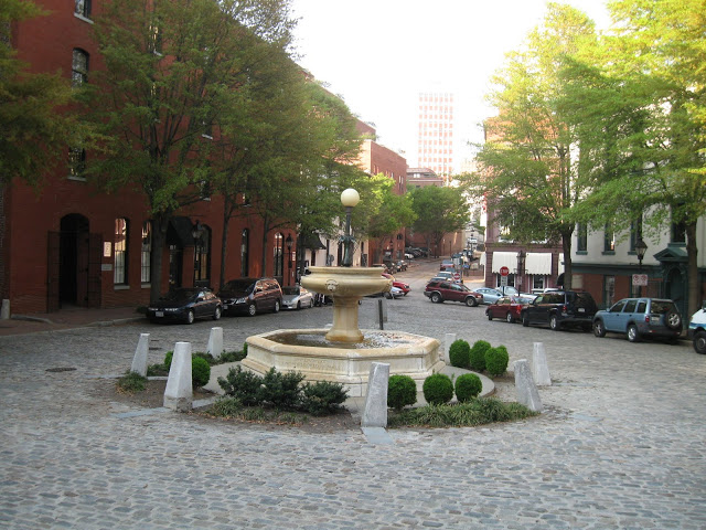
Fountain at the Intersection of Brook Turnpike with West Broad Street [Shorpy]. The fountain has
dog water basins at the bottom. It still serves the police horses at a
location behind the Bill "Bojangles" Robinson statue on Brook Turnpike.  

Capt. Charles S. Morgan gave this marble fountain to serve draft horses at the
center of the city's tobacco warehouse district. It is inscribed
"In Memory of One Who Loved Animals." 
The fountains that provided water to animals entering the city included an ornate cast iron one, now gone, in Manchester and the plain stone structure that distributed water to both large and small animals at the point where Brook Turnpike entered Broad Street. It was later re-located to a site now behind the Bojangles Robinson statue where it serves police horses with fresh water. A third fountain for horses and oxen, made of marble, still stands at the center of the Shockoe Slip in 1905, where tobacco was deposited in one of the city's huge warehouses. Its setting has been marred in recent years by unnecessary foundation planting.


The Monroe Park fountain was followed by similar structures in the late nineteenth and early twentieth centuries, including a one depicting a heron in front of the Governor’s Mansion (unfortunately replaced with a very conventional iron one during the Robb administration).  

Wayside Spring, Forest Hills Park
[https://foursquare.com/v/wayside-spring/4c73a7667121a1cda29a65d1]
Richmond residents who preferred spring water to the municipal water supply or didn't have water piped to their houses could get water that welled from the ground in artesian springs that were opened and maintained in parks around the city. These included Byrd Park, Wayside Spring in Forest Hills Park, Fonticello Park (now Carter Jones Park), where the spring has been modernized and still flows. A spring also flowed into a concrete trough along the side of Richmond Henrico Turnpike in Barton Heights. The spring water, which once poured through three lion's heads, is no longer running.
Kanawha Plaza Fountain, located as part of a plaza designed by Robert
Zion of Zion & Breen, completed in 1980

More recent fountains, such as those at the Kanawha Plaza at the James Center, installed during urban improvement projects in the mid-twentieth century, replace the conventional allegory of nature projected by earlier fountains with a literalism that fails to convince the viewer of either its natural origins or its cleanliness. 

Libby Hill Fountain, 1990s.
In contrast, the conventional iron tazzo (tiered) fountains added in recent years on Libby Hill have a much less focused connection with water as a carrier of civic meaning. They serve merely as park design amenities. These amenities (examples of the widespread rethinking of traditional fountains as superfluous “water features”) which, while they signal renewed pride in the park’s grounds and an improved level of upkeep, largely fail as markers of the public good. Their placement and form, like their recirculating contents, are inadequately related to the nature and history of the site.  
 

Wednesday, June 13, 2012

Trees as Civic Amenities and Reinforcers of the Urban Scale


If you were alive in the Paris of Louis XIV, the impression of these new boulevards and avenues would be of a tremendous formalizing of nature, rather than of urbanization. The chief device, the parallel rows of trees was a fairly easy way to achieve stunning monumental effects and perspectives with little actual material and labor. These abstract diagrammatic schemes signified little beside the kings' ability to make a rural landscape orderly --something he clearly relished. However, when they finally were developed with buildings decades later, the boulevards and avenues of Louis XIV would become templates for the best of the Second Empire's new street typologies, and they remain models for excellent street sections into our time.
                                           The City in MindJames Howard Kunstler

Thanks to The Gates of Memphis for the quote.


Monument Avenue, Richmond, mid-20th c. 


Le Notre's Garden at the Tuileries, Paris, 17th c.
The use of the tree as an urban-scale street amenity is a relatively modern development. Trees were restricted to gardens among the narrow streets of most cities. By the seventeenth and  eighteenth centuries, trees were organized into bosquets and rides intended to delineate the vistas and axial routes that converged on Baroque palaces. The primary purpose of trees in the baroque landscape was to underline and sculpt the lineaments of site design. A secondary purpose was served by providing shade for those viewing or passing through the landscape. 
As the European city expanded, it enveloped and expropriated the ornamental parks and hunting grounds that were originally set apart for royal use. Planners of eighteenth-century continental and British cities extended the language of Baroque garden design to the entire urban form, underlining important routes, axes, and nodes with trees planted in neat patterns and rows. As boulevards and promenades appeared in the late eighteenth century, individual trees were subsumed within a grand overall scheme and planted in such a way that their form, color, and size assisted in directing the eye and setting the scene. Massing of trees of one species or reiteration or alternating patterns among several types helped clarify the city’s urban order.   
Richmond, like most American cities, was slow to enable any collective provision of shade for pedestrians. Such as there was along the streets was provided by the overhanging boughs extending from some of the city’s large gardens. Richmond’s chronicler Samuel Mordecai remembers a house on Main Street near the foot of Church Hill which was surrounded by a walled garden and flanked by a row of elm trees that were “like an oasis in a desert, and furnished a refreshing shade to the pedestrian on a hot summer day- of which I can speak from experience.” 

B. H. Latrobe, Lombardy Poplars on Pennsylvania Avenue, Washington, before 1814.
Americans began after the Revolution to place trees in the growing cities of the eastern seaboard. Thomas Jefferson likely saw trees in a supporting role in the design of the new Capitol district atop Shockoe Hill.  One of the earliest references to street trees in Richmond is the planting of Jefferson’s much-favored Lombardy Poplars along Main Street at the foot of Shockoe Hill in the last years of the eighteenth century. Widely propagated in Northern Europe for their quick growth, elegant shape, and Italian manners, Lombardy Poplars were selected by Jefferson to line Pennsylvania Avenue during his occupancy of the White House. According to chronicler Samuel Mordecai, the poplars in Richmond grew to a great height until they were attacked by a variety of caterpillar. Although still widely used for urban ornamental plantings, Lombary Poplars rarely live more than fifteen years. Evidence suggests that Richmond joined other eighteenth-century American cities in adding trees along other selected streets for urban emphasis, shade, and utility. Richmond streets and alleys received tree names related to the kind of trees that were planted along their edges. 

Regular lines of trees fill Godefroy's Capitol Square from Mijacah Bates' map of 1835.
The City’s Public Square, containing the Capitol surrounded by an irregular and undeveloped terrain, was improved under the direction of French-born engineer Maximilian Godefroy between 1816 and 1820. He transformed the ravines flanking the Capitol into two tree-lined pedestrian boulevards each containing a cascade organized by a series of marble basins. When the saplings were damaged by cattle in 1818, the city responded by providing new plantings of exotic and native varieties.  When the Capitol Square was re-landscaped in the early 1850s, naturalistic plantings of native species were preferred by landscape architect John Notman to exotics. Capitol Square, as seen in the drawing below, was now surrounded by sidewalk trees, each side planted with a different species [Potterfield 62].   The square containing City Hall was landscaped at the same time and contemporary images attest that it was a cool retreat along Broad Street, even as the trees nearly concealed the structure’s columned portico. Trees were added along some residential streets as well.   
Trees are seen along residential streets in Court End at the end of the Civil War.

Evocative illustration of the shaded front of Mills' City Hall from Dabney, The Last Review, 1934 
The antebellum Powhatan House Hotel on Broad Street where the Patrick Henry Building (the former State Library) stands today. The 
 treatment of the young trees with protective wooden guards 
and the whitewash on their boles was a common practice in this period. 

Civil War-era photograph of City Hall from Capitol Square, 1865
showing trees planted in the previous decade and housed in protective wooden surrounds 
Detail from the 1850s showing Ninth Street on the
west side of Capitol Square [Reps]
By the middle of the nineteenth century, the city government responded to the city's increasing density by recognizing the need for a series of public recreational parks to supplement the Public Square, now known as Capitol Square. Acquired in the 1850s, these tracts remained unplanted fields and hillsides until after the end of the Civil War. After the war, the city began to lay out paths and place trees in these parks, which included Monroe Park, Libby Hill and Gamble’s Hill, and others established after the war, including Chimborazo, Taylor’s Hill, Jefferson Park, and Riverside Park. Monroe Park was laid out by Wilfred Cutshaw in a series of criss-crossing paths that were lined with trees. As in the city at large, each path was lined with consistent allees of matching trees. A catalog of 26 tree varieties in 1904 shows the number and types of trees used in the park, which included sugar maples, silver maples, several varieties of oaks, elms, and lindens.  
Col. Wilfred E. Cutshaw
As Tyler Potterfield has shown, Wilfred Cutshaw, city engineer from 1873 to 1907, was responsible for the transformation of Richmond from a treeless pedestrian desert into a well-funded follower of the national “City Beautiful” movement. He established a program for the “proper selection, spacing, and planting” of trees throughout the city. Over fifty thousand trees were raised and set out by the city between 1890 and 1904 with the intention of establishing a tree canopy over most of the city’s walkways.  An amenity that was formerly restricted to special precincts, gardens, and urban parks was extended to the entire city at public expense. Even so, the strictly commercial sections of the city were never lined with trees: visibility and ease of access were more important to the city's stores and shops. The rows of brick commercial buildings fronting on narrow pavements or boardwalks and shaded by continuous lines of awnings did not require any added shade or emphasis.   
At its peak in the first half of the twentieth century, Richmond took its street trees very seriously. The city employed an arborist and raised hundreds of trees in an large nursery around the reservoir in Byrd Park, later moved to Bryan Park. Each residential street in the city was planted in a tree species that gave it a distinct character. Favorite trees were the American elm, the sugar maple, and the silver maple. Other varieties included the linden, the tulip poplar, the sycamore, and several types of fast-growing oaks. Boulevard was lined with linden trees, likely in conscious emulation of the famous Unter den Linden strasse in Berlin.  Monument Avenue was lined with sugar maple trees. Important sections of many streets, including Floyd Avenue, Clay Street, and Franklin Street, were lined with tall and graceful elms.  
Surviving section of alternating American elm and tulip poplar trees in the 3500 block of Seminary Avenue, Ginter Park
Trees were selected from popular tree species with wide, open crowns to provide maximum shade, long life, and large size. The city regularly replaced missing or damaged trees to match the adjacent types. Trees were also pruned to improve shape and to remove inappropriate growth and dead branches. Until the 1960s, this regimen was kept up. New trees were provided with wooden support frames to prevent damage to the young stem. 
The patterned trunks of sycamore trees lining a side street in Laburnum Park.
Richmond abandoned its tree replacement program in the 1970s. Trees were added to major new streets and along thoroughfares only as special projects funded by the city procurement process. Trees are, however, pruned and removed as required by a team of arborists contracted by the city. Renewed interest in tree replacement has led, in recent years, to a piecemeal replacement program, often led by volunteer or neighborhood advocates. The Richmond Tree Stewards program was organized as a citizen involvement program by one of the city’s arborists. It undertakes training and certification of citizen volunteers, who assist in pruning, replanting, and watering trees.  
The city’s current arborial program is informed by the contemporary idea of the “Urban Forest,” which traduces the classical and neo-Baroque intentions of the city’s nineteenth- and twentieth-century planners. Instead of using trees to support, by their placement and form, the city‘s urban fabric, tree management policy is governed by concerns for tree health, avoidance of electrical wires, and protection of sidewalk pavements.  For example,  planting in single species is strongly discouraged, since it is thought that disease spreads more readily among trees of the same type whose roots are interlaced. As a result, when new trees are planted, specimens of four or five arboist-recommended tree varieties are now placed without pattern along most of the city's streets. 
Comparing the form: mature (and soon to be replaced) American elm to left and young Zelkova
replacements at center and right  on the 3700 block of Brook Road
Today, however, the rate of planting is not keeping up with tree mortality and the existing stock of trees is rapidly diminishing. Many stately trees, such as maples, once prized for their spreading crowns and autumn color are no longer considered appropriate for this climate. Gum trees and ginkos are among the most commonly required where large canopies are permitted. Zelkova trees have been widely used to replace American elms after elms were decimated by disease, although improved strains of the arching, lacy American elm are now available. Zelkova have proved to be radically different in form, habit, and longevity. Trees of smaller stature and habits, including such widely differing types as redbud and crepe myrtle, are placed under electric wires and in other location where height is seen as a problem. Trees are no longer planted at sufficiently close intervals to result in a continuous canopy. The lack of consistency of tree scale and form along city streets has meant a gradual degradation of the coherence of Richmond's urban form. This means not only a loss of shade, but of the distinctive color and character of individual streets and neighborhoods.