“First, What kind of life was lived in this place, that is, Why and how did its builders build as they did?
And second, what rules with general validity and applicability did they follow?”
Carroll William Westfall, Learning From Pompeii.


Showing posts with label Jefferson. Show all posts

Tuesday, May 5, 2015

Westward Ho: Watson's Tenement, Turpin's Addition, and the Development of Shockoe Hill


Watson Ho., Detail of Madison Map of 1818


As we have seen elsewhere, the plateau on top of Shockoe Hill was laid out in streets in 1768 and the approximately 90 full squares, each containing four 1/2-acre lots, and 16 half squares. This new town called Shockoe, part of the lands of William Byrd III, was incorporated into the city in the following year. The development on Shockoe Hill was slow to develop, but the area at the top of the hill attracted some merchants and overnight lodging at the top of the old County Road that entered Richmond from the east at Gillies Creek and connected the town to points east and west.  Maps show that the narrow, curving way that traversed Henrico from east to west (probably begun as an Indian path) climbed the bluff from Shockoe Creek to the top of the hill. It continued to the west in a path that roughly approximated H or Broad Street, but did not strictly obey the official guidelines of the grid.


Watsons Tenement on the inset map of Byrds Lottery on Richard Youngs 1809 Map of
 Richmond. This map originated in 1768 and includes the platted town of Shockoe west
 of the creek labeled Town Land.


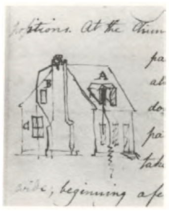
The tract of undeveloped land to the north and east of the County Road was known as Watsons Tenement. It had been leased by Philip Watson, merchant, from William Byrd III- the lease appears to have been renewed in 1757. It then comprised 128 acres and included, according to the lease of 1757, a brick dwelling where the said Philip now dwelleth, a brick store, and a frame granary. It seems likely that the brick house was the same as the one 1/2-story dwelling that later served as the Council House and the town residence of Col. John Mayo.  The appearance of that house is known from a sketch done in the notebook of B. Henry Latrobe in 1798, showing the damage done to it by a lightning strike. 
Detail of James Madison, A Map of Virginia 1807. The Philip Watson/Council Chamber
 House is seen to the right of the center fold, standing nearly alone at the top of the
 steep slopes of Council Chamber Hill.


The house apparently built for Philip
Watson, later the Council Chamber
from B. Henry Latrobe, Mayo
House, Notebook, 1798

Thomas Turpin purchased Watsons Tenement from William Byrd III [probably recorded in the General Court and now lost] as noted in a deed of 1783, when Turpin sold 93 1/2 acres, the remainder of the tenement after the sale of lots on the hill, to his son, Dr. Philip Turpin. The western section of the tract that was occupied by Watson was left blank on the plat of Shockoe that was made in 1768, north of Broad between Eighth and Twelfth streets. This section, later known as Turpins Addition and Court End, was laid out in lots and incorporated into the city by Thomas Turpin in 1780. The undeveloped remainder of Watsons Tenement ran east down to Shockoe Creek. The southern portion of this sloping land, containing Watsons brick residence, had been considerably improved and was valued by a jury at 4,000 lbs specie. The other half, to the north, where the Quesnay Academy,  Richmond Theatre, Baptist Meeting House, Medical College, City Jail, and Lancastrian School were to stand, was considered less valuable, assessed at only 1,000 lbs. 


Detail, Mijacah Bates 1835 Map of Richmond showing the area of the Burial Ground. The
 three lots extending west from 15th Street were the site of the residence of James
 Goodwin in 1807. The irregular lot on which the City Jail (1830) and the Lancastrian
 School (1816) are shown was public land on which a burial ground, gallows, and
 magazine could be placed.


The irregularity of Watsons Tenement as it sloped down from the eastern margin of the Shockoe Hill plateau meant that it was slow to be incorporated into the citys official grid. Probably as a result, parcels of land at the top of the hill were available for use by public institutions like schools (the Academy of Monsieur Quesney and the Medical College), a theater (the Richmond Theatre and the later Monumental Church), and churches (the Baptist Meeting House).  At some point, the city acquired a larger tract of between two and three acres spanning Franklin Street along the west side of the creek for civic purposes, including the eventual construction of the City Jail. Missing city records mean that it is difficult to say in what decade the city acquired the section from the Turpin heirs. Minutes of the Common Hall are missing from May of 1795 until January of 1808 and no mention of the acquisition is recorded in the deed books. The notorious sites associated with the practice of slavery, such as Lumpkins Jail and the slave auction houses were located on the part of Watsons Tenement along the creek to the south of Broad Street. 


Jefferson layout for the three Capitol squares, 1780, from Reps. Names of the original
 lots owners are shown.

Shockoe Hill was transformed by the arrival of state government. The 1779 act that relocated the capital to Richmond from Williamsburg authorized the Directors of Public Building to find a location for the government buildings in the open and airy part of the city. Two locations were proposed by the major landowners in two bluff-top locations: Shockoe Hill and Richmond [Church] Hill. In the following year the General Assembly authorized the appropriation of a site on Shockoe Hill for a new four-part government complex including a Capitol for the legislature, a Halls of Justice for the courts, a State House for the executive boards and committees, and a residence for the governor. Richard Adams, owner of much of the land on Richmond Hill, thought that he had Jeffersons promise and broke off his friendship when his proposal of twelve lots for the public buildings on Richmond Hill was rejected.


The process of valuing the land to be requisitioned for public use on Shockoe Hill began in 1783. The present site of Capitol Square seems to have been considered from the first, but two tracts that were also considered for taking comprised an area of thirty acres that was part of the former Watson Tenement. This parcel belonged to Horatio Turpin and his brother Dr. Philip Turpin, sons of Thomas Turpin, Thomas Jeffersons uncle. It was located on Council Chamber Hill, to the east of the County Road [Governor Street]. Owing to the loss of records, including those pertaining to the General Court in Williamsburg, where the Byrds recorded most of their transactions, the history of the property is vague. As we have seen, the Turpins acquired Watsons Tenement in its entirety after the lease was vacated, well before 1779. It was in that year that Thomas Jefferson, during his term as governor, occupied a house near the corner of Thirteenth and Broad belonging to Thomas Turpin.   

1768 plat of the Town of Shockoe as found among Jefferson's papers with
 undifferentiated grid pattern. The pre-existing tenements (including the very large 
extent of Watson's Tenement) and lots along Shockoe Creek are shown at the right.  

Horatio Turpin, deemed the owner of the lots most valuable for public use, offered the thirty acres on the Council Chamber Hill for sale to the state and, for free, two 1/2 acres of land that were part of the tract.  It included the compact brick building identified as the house now used by the executive, known as the council chamber. This was offered to the state as the site for the governors house [Journal of the House of Delegates 27 June 1783].  This parcel, later the home of  John Mayo, would have made an excellent and scenic location for the executive mansion. It was later proposed as the site of a villa for the Mayos by B. Henry Latrobe.


Other lots were valued as well from 1781 to 1784. These included all the lots that would make up Capitol Square. Most of these were empty of buildings, but at least two lots on the immediate site of the Capitol contained buildings. John Gunn had built two houses, occupied by himself and a tenant, on lots 391 and 404. In addition two lots near the future site of the Governors Mansion, owned independently by cooper John Ligon and merchant Zachariah Rowland, included valuable buildings. The large frame house on lot 357, owned by Rowland, was used for the next twenty years, with increasing levels of dissatisfaction, to house the governor and his family.  This dwelling was close to the County Road, which it faced, and was sited well below the level of Capitol Square.  Since, according to the 1782 tax lists, Rowland had arrived in Richmond no earlier than 1780, and was not registered with this lot in 1782, it seem likely that someone else had it built at an earlier date (lot numbers are missing for this ward in the tax list).  

The general location was finalized in 1784, when the unitary Capitol building, designed to house all the functions of government, was commenced at the center of the square. The Directors of the Public Buildings decided not to use the thirty-acre site purchased from Turpin, and the legislature returned the land, for which he had not been paid. The state kept the two-acre Council Chamber part of the site and traded it for another portion of the tract just across the County Road from the governors house. This lot was already in use as a garden, presumably for vegetables to supply the governors table and to provide an attractive setting across from his front door.


Philip Turpin's Lots , 1787, Library of Virginia. Main Street is today's Broad Street and the
 street at the right edge is 13th Street. Lot No. 749 appears to be the lot that Gov.
 Thomas Jefferson rented from Thomas Turpin in 1779.

In 1787, Turpin was informed that the public had no occasion for the use of any part of his land, except two acres. . . for the purpose of having buildings erected thereon for the residence of the Governor which buildings had they been erected, would have greatly enhanced the value of your petitioners property lying adjacent. Turpin petitioned in 1791 for redress for the loss of value to his property [Richmond City Legislative Petition, 11 Nov. 1791, Library of Virginia]. He continued to sue for relief until well into the nineteenth century, finally receiving compensation for the loss of the two acres in 1809. Meanwhile he had sold the remainder of the Council Chamber tract to Col. John Mayo in 1789.

The Turpin tract was entirely in the hands of Philip Turpin by 1775. He had laid out the flat part at the top of the hill in lots conforming to the adjacent grid pattern by that date, when he sold lots no. 781 and 782 to James Monroe [Richmond City DB 1:43].  The land on Council Chamber Hill and sloping down to the Shockoe Creek he sold in larger unnumbered tracts.  As we have seen, these less likely tracts became acceptable sites for public and civic uses. In 1786 he sold a lot to the trustees of the Quesney Academy [Richmond City DB 1:119], which would, after the Richmond Theatre burned, become the site of Monumental Church. At that time he guaranteed that Broad Street (the Main Street on Shockoe Hill) should be extended along the entire frontage of the Academy lot. The Baptists acquired a lot east of the Academy. 


Map showing location of the Latrobe Theater

The eastern edge of Shockoe Hill became a prominent location for civic and academic buildings. In the late 1790s it was proposed as the site for a great new Episcopal Church which would have effectively replaced Henrico Parish Church (St. John's) on Church Hill. This church was proposed for an extremely prominent location on axis with (in the center of) Broad Street, appropriate for the position of an established church, a position still held in some contention for the descendent of the Church of England. The church, seen roughly sketched in on a plan of the area drawn by architect B. H. Latrobe, was never built, nor was Latrobe's famous hotel/theater combination seen just above. The history of the eastern slope of Shockoe Hill is continued in part here.
Wednesday, March 12, 2014

URBS IN RUS: COURTHOUSE SQUARES IN VIRGINIA


Hanover County Courthouse of c 1740 (VDHR], where the arcaded piazza,
at grade, fronts a raised courthouse interior.
 
In eighteenth- and nineteenth-century Virginia, the civic architecture built in the rural counties that spanned the state, such as courthouses, was always closely related to the public buildings  found in cities and towns. The Capitol at Richmond, like its predecessor at Williamsburg, stood at the heart of a political system that was housed in public buildings erected at a series of crossroads hamlets. By their form and ornament, mostly derived from provincial English sources, these meticulously imagined structures illustrated for their users the way in which the political order could promote the common good. By the 1730s, a continuous hierarchy of substantial civic buildings was in place, from the courthouses and jails at the local level to the capitol, prison, and governor's house at the state level. Local and state leaders, spurred by Thomas Jefferson, successfully undertook a thorough reformation of civic architecture at every level. They projected a new series of civic buildings in order to set a rigorous standard, worthy of the new republic, for architectural achievement in both the public and private realms. Local leaders adapted regionally appropriate building types (like the basilica-plan courthouse with a piazza and a curved end wall) that served specific political orders, and transformed them through a careful use of classical and Renaissance architectural forms.  

The Virginia Courthouse Square

In the overwhelmingly rural context of eighteenth- and nineteenth-century Virginia, county courts were the dispensers of justice, regulation, and administration for most of the widely dispersed population. County government involved a monthly gathering of the county's elected political leaders at a central point located along the county's most important route. The two most important buildings associated with county government in colonial Virginia were a courthouse in which to conduct the basic functions of local government and a “prison” or “gaol” in which to hold two sorts of individuals: those who were awaiting trial and/or punishment and those who had been identified by the court as debtors. Given the absence of towns or villages in many counties, public buildings were often placed on an enclosed tract of one or two acres, entirely surrounded by an open agricultural landscape, usually referred to as the "public square."

The courthouse square is closely related to the market places of medieval and Jacobean England.  The English market square typically included a government building in the form of a town hall/ market hall equipped with a loggia, piazza or portico, as well as a market cross, the venue for official announcements and the public administration of justice. The rural nature of Virginia counties precluded regular markets held in the same building that housed local government, such as was the case in England and in larger Virginia towns such as Richmond and Fredericksburg, but fairs and court days brought the public square and the area around it to life on a monthly or semi-annual basis. In much the same way, the stocks and whipping post found in courthouse squares were instruments long associated with the conduct of justice at the local level on both sides of the Atlantic.


The Capitol at Williamsburg (1705, reconstructed 1934)
stood at the top of the hierarchy of colonial government.  
The central "piazza," entered through brick arches, is 
related to architectural forms associated with town halls 
in England. The curved apses, ultimately derived 
from ancient Roman basilicas, contained seating 
for political and judicial authorities. 
The King William County Courthouse (c 1730). Beginning
about 1730, county courts began using more permanent
construction materials.  Arcades or "piazzas" not unlike 
the central piazza at the Capitol began to appear at 
some courthouses, along with curved back walls 
containing, like those at the Capitol, the seats from which the 
political and judicial leaders exercised their authority. 


The arched piazzas at eighteenth-century Virginia courthouses (and at the Capitol in Williamsburg) are related to a long tradition of civic architecture, and were provided provided for both practical and symbolic reasons. Their models were found not only in the market halls of England, but in the courtyards of mercantile structures in London, Oxbridge colleges, and local buildings such as almshouses. The ultimate reference, recognizable to classically educated Virginians, was to the Roman forum, particularly as interpreted by Andrea Palladio. The forum was seen as a significant precedent for enclosed courtyards and for the larger public square. Carl Lounsbury has pointed out how Christopher Wren made the arcade at Trinity College Library in Cambridge “according to the manner of the ancients, who made double walks . . . about the forum” [Carl Lounsbury, The Courthouses of Early Virginia: An Architectural History, 2005].  

When Leonard Bacon (1801-1881), a nineteenth-century Congregational clergyman, explained the reasons behind the creation of the New Haven Green, he echoed what countless other classically trained civic leaders understood. The public square was "designed not as a park or mere pleasure ground, but as a place for public buildings, for military parades and exercises, for the meeting of buyers and sellers, for the concourse of the people, for all such public uses as were reserved of old by the Forum at Rome and the ‘Agora’ (called in our English bibles ‘the market’) at Athens, and in more recent times by the great Square of St. Mark in Venice; or by the ‘market place’ in many a city of those low countries, with which some of our founders had been familiar before their coming to this New World" [see Early British and American Public Gardens and Grounds].

According to Lounsbury, the pre-Revolutionary courthouse was often a small and undistinguished building. However, as the eighteenth century progressed, members of the principal county families began to see the courthouse and the church as arenas for architectural expression. They became the most architecturally developed buildings at the scale of the county, and increasingly combined permanent materials, regional architectural forms, and cosmopolitan classical features imported from abroad. The floor plan was adapted to include the special features required for local government in Virginia. Courthouses began to include a semi-circular seating area for the judges facing the entrance that, as we have seen, was ultimately derived from the curved ends of the basilicas where justice was administered in the Roman forum.

The building was the scene of a solemn enactment of the rituals associated with the administration of justice at this local and most familiar level. Although the deferential society of Virginia enforced a clear demarcation, socially and architecturally, between the sitting justices and the majority of the county's population, the local scale meant that justice (at least for the free members of the community) was rooted in the close relationships of all the participants. These included the justices, the plaintiffs, the jury (when empaneled), and the spectators, each of whom took a part in the action. 

The Virginia Capitol preceded Jefferson's successful 
campaign for a proto-typical county courthouse by some 
years. As he hoped, the temple form eventually prevailed 
over older courthouse types. The architectural relationship 
of many courthouses to the Capitol underlines the 
hierarchical connections between local and state government.
The Charlotte County Courthouse (1823), part of the
transmission of Jefferson's program of revised civic 
architecture across every level of government. After the 
1820s, versions of the temple-form courthouse became 
closely associated with county government.


With increasing prosperity in the nineteenth century, county leaders sought to replace their aging public buildings. Thomas Jefferson proposed a new prototype for the courthouse that was very influential in determining the form that Virginia courthouses would take for next 100 years. According to Charles Brownell, Jefferson made the case for a temple-form building, scaled and ornamented appropriately for local government, using Palladio's Tuscan order to "wrap" the traditional basilica form that had been developed in Virginia over the previous two centuriesThe eighteenth-century piazza was replaced by a classical pedimented portico, but the floor level remained nearly at ground level, where it continued to provide a transition between interior and exterior and act as a sheltered place to transact legal business, make deals, and take cover in the busy, fair-like atmosphere associated with the special days on which court was held. 
   
The Goochland County Courthouse is one of the finest examples of Jefferson's program to improve the quality of civic architecture at the local level. 
The Tuscan order as employed here results from a careful inculcation of classical principles among a cadre of designers and workmen.
The courthouse square received an increased level of attention in the first decades of the nineteenth century. County officials began to place new buildings in symmetrical locations flanking the courthouse and to clean up the roughly kept grounds. At the same time that the public square (Capitol Square) in Richmond was landscaped and enclosed with an elegant iron fence, counties began to make efforts to order the local landscape by adding ornamental gates, fences or brick walls, intended, not only to prevent the entry of cattle and pigs, but to set the public square apart from the rural land for civic use. 


Hanover Courthouse by Benson Lossing. This drawing documents the Courthouse Square in the early 1850s. Note the well and the trees surrounding the courthouse and how the paths from the tavern (center), the jail (right), and the clerk's office (left) run through the arcaded porch.

For example, Goochland County saw an intensification of activity related to the courthouse that begin in 1820. County leaders were clearly resolved to upgrade the architectural character of the public buildings and the square in which they stood. A higher level of expense was required to achieve these goals in response not only to increasing prosperity, but to the program of architectural improvement widely promoted by Thomas Jefferson. These included the use of permanent materials and improved adherence to normative standards of classical design. The county went great lengths to improve the square. A new post and rail fence with handsome gates was built round the square and it was planted with ornamental trees in the spring of 1820. The county court ordered a brick wall to enclose the square in 1840.


The Goochland County Public Square in 1929. The "crier's platform" shown is otherwise
 undocumented, may also be associated with the location of the stocks and pillory
 [Goochland County Historical Society].   

The courthouse square was the scene of the county’s shared social and political life: festive court days, somber executions, political rallies, and the celebrations associated in Virginia with voting days. As new civic buildings were added, they were often placed to flank the courthouse, following the tripartite form used earlier at grand Virginia plantation houses. These were ultimately derived as well from eighteenth century pattern books with Palladian origins. When the Hanover County court added a clerk's office in the second decade of the nineteenth century, they carefully placed it as a dependency to the side of the main building. Later, when they built a new jail, it was placed in the corresponding position at the other side.  A similar layout can be seen at nearby Goochland County's public square, where the courthouse of 1827 is flanked by the jail and the clerk’s office, dating from 1825 and 1847, respectively. 


Goochland's Public Square in 1915. The one-story Clerk's Office is at the far left. Note
 the three building along the rear line of the square. Other privately owned buildings stood
 along the sides and front (see 1929 map above) [Goochland Historical Society]. 

In many courthouses, landholders bordering the public square sold off in small lots for use in constructing law offices, inns, and even Masonic lodges. This can be seen in miniature rows of tiny law offices opening off the public squares in towns like Woodstock and Culpeper and in the several brick and frame structures that around the square in early twentieth century Goochland. Even thought these lots were not located on official streets, their owners thought it appropriate to informally front their private buildings directly on the green, as a kind of nascent urbanism.


Powhatan Courthouse Tavern, Powhatan County, Virginia a late eighteenth- or early nineteenth-century tavern [Powhatan County Historical Sites].

Hanover Tavern, dating from 1791, placed directly across the main road from the courthouse [VDHR].
The Goochland Courthouse Tavern, operated by Benjamin Anderson, stood directly
opposite the courthouse. An "Old Tavern" and a lodging house stood on either side of the square,as can be seen in the plat below [Goochland Historical Society]. 
1822 Plat of the Goochland County Prison Bounds (area within which certain prisoners
 were allowed to move about). It shows the T-shaped courthouse that proceeded the
 present 1827 courthouse, the taverns, stable, and the old jail [Goochland County Deed
 Book 25: 325].

In rural courthouse communities, the tavern, located along one side of the square, provided the essential counterbalance to the courthouse. At Hanover, the rambling tavern, rebuilt in 1791 and enlarged several times afterwards, faced the courthouse from across the road. It served as a home for visitors from outlying parts of the county during court sessions. It was the setting for much of the social exchange that bound together farmers and planters at the county level. By the late eighteenth century, Virginia taverns in the both urban and rural locations often were fronted with a long porch for warm-weather seating and social life.

In Cumberland County, the courthouse of 1778 did not face the tavern. In 1818 the new courthouse was positioned directly across from tavern. As Marc Wagner observed,
whether or not it was intended, the "interesting relationship of portico facing portico . . . created a town center where outdoor gathering would have had appropriate ceremonial legitimacy [NR nomination, Section 8, footnote 6]."

In its fullest form, the extended tavern porch formed one side of a partially enclosed public square. It served as the counterpart to the piazza of the courthouse, each symbolically extending toward the other. Together, they represented a porous boundary for the model of the civic realm that was enacted each month in the public square.