“First, What kind of life was lived in this place, that is, Why and how did its builders build as they did?
And second, what rules with general validity and applicability did they follow?”
Carroll William Westfall, Learning From Pompeii.


Monday, July 4, 2011

Letter to a Professor

Caro Professore,

I have really appreciated your willingness to discuss the issue of what I will call uniformity in architecture, or perhaps more appropriately, urban scale architecture. Obviously this is a point of contention among architects and urbanists and I will need to be able to justify my position. As I understand it your argument is predicated on the belief that modern issues in urban design can only be addressed by a carefully composed variation in architectural and urban forms, rather than a single unified vision. Unity in this view is achieved not through uniformity, like an endlessly repeated theme, but through differentiation which provides for the individual “character” of a place. This now commonplace approach is founded in the work of Leon Krier.

I think we can both recognize a pattern in our discussions this semester; namely, the role of regularity and uniformity in architectural design and in urban planning. I am convinced that there is truth to what I am attempting to put into words and buildings. I can see it both in writing and traditional architecture and urbanism; it is my lack of eloquence that is doing it a disservice. This is something I have finally had to defend because it helps me explain how architecture integrates commerce into the civic realm. So, I will try to first do the best I can to describe in writing what I have been trying to say, and secondly, attempt to defend it.

Beginning with my conversations and work with Mario Gallarati, based on the Muratori school of urban design a year and a half ago, I began to be interested in the study of formal Renaissance squares. As a student of the Muratori school, Mario Gallarati has consistently worked within the understanding that cities and buildings are composed of a number of scales and that to be successful each part must engage its appropriate station in the hierarchy of the city or state. Given this understanding, it is not surprising that I am interested not only in individual buildings, but in the concept of the formal square, and on a larger scale, the form of cities. The Muratorian approach is based on this idea of an intelligible system of architectural scales. These urban scales can be described or “read” using “synoptic tables” that compare traditional building similarities and differences from the scale of entire regions down to the scale of window treatment. I began to read the few translations available on Muratori and his students. I tried to test it against the indubitable theory of my professor Carroll W. Westfall. So far I think them consonant in their essential ideas; the main difference being their focuses on theory and practice respectively, and the empirical approach of Muratori in contrast to Westfall’s reliance on rhetoric. Together they give me a compelling theory of architecture combined with an “operative system” of practice. I am afraid I am an inadequate evangelist of this theoretical combination and have barely scratched the surface of understanding either thinker, but I am enjoying making the best of what I have.

From what I understand of Westfall and Muratori it seems that the different architectural scales of the city embody the order of communal life which has the common good as its end. These various scales are hierarchically more or less important according to the degree to which they deal with the public realm. More directly, parts of the city on the architectural, or building scale are subordinate to the urban scale (Muratori), or “urban ensembles” in the words of Westfall. Urban ensembles are members of the city, but are in turn, wholes composed of building members. Significant events in the urban scale might include civic places such as law courts, libraries, markets, theatres and baths. These places are more important than private buildings, but in turn subordinate to the larger, more public building which is the city.

The various scales are represented by their use of similar components. Without similarity between these scales comparison between them would be impossible, and yet without difference their location in a higher order would be equally unintelligible. Comparison is not the same thing as finding out where you are.

Building Scale
Buildings can appear related to each other only by virtue of their parts being obviously related to one another, or obviously different in a similar way. Westfall explains this as the “pattern of the assembly of the components” and gives the examples of basic compositional types: temples look like temples, houses look like houses, etc. because they are made of the same parts. Those parts, however, are never assimilated in the same way. Buildings also relate to one another according to the physical character of these components i.e., materials, ornament, size and level of finish. These scales operate by increasing in their level of realization as they reach higher importance in the public realm. The capitol or royal palace is the most fully ornamented and finished building in a state, the city hall the best dressed of all the parts of a republican city and so forth down to the most diluted branch post office or library. Within individual buildings many different activities can take place, however, every building, according to Westfall, is in some way a dwelling, whether it be of a god, a king or a pleb, and that specific purpose of the building is what drives its overall treatment. Different floors, wings, and rooms are realized according to their individual purpose, but on a subordinate scale within the context of the building.

Urban Scale
The urban scale works in exactly the same way. In a city the urban scale is almost always the most important. Occasionally, the territorial scale may override it (as in the Palazzo del Capitaniato in Vicenza, or the Virginia State Capitol), but they each require varying levels of a related treatment. More important streets such as those linking significant nodes in the city or territory are represented as such by their relative width, or because the buildings on their “pertinent strip” are collectively on a grander scale. The level of finish or ornament of a street is the degree to which it is treated in a related or unified way. Perhaps it is lined with arches, or the buildings facing it share the same cornice, etc. The most important public places, traditionally public squares, receive the highest levels of ornament and most thorough treatment in terms of their realization as single bodies made up of different parts. Traditional squares are often wrapped with arcades or colonnades that are made up of related components, the most important receiving the most unified treatment. The distinctness with which the various purposes of the buildings surrounding the street or square are represented is proportionate to their relative importance in the life of the city. The cathedral may remain entirely distinct in even the most formal European squares because of its complete dominance in the public life of the city. Conversely, commercial or industrial activities serving the private realm will almost always be entirely invisible.

These traits are common to almost every city in the Greco-Roman tradition to some level or another. Often, as in the case of S. Petronio in Bologna, an element of the city will remain unfinished. To say that the building is better as it is today is debatable, but to argue that the intention of the architect was to leave it half-finished is preposterous.

So too with the urban scale. The charm of Italian piazzas is often attributed to the informal character in which Goethe encountered them in the 19th century. This is the beauty of the relationship between contingent reality and an ideal. Perhaps a piazza embodies more of a city’s order through its un-realization. I certainly find them beautiful, livable places. Perhaps they are more beautiful in ruins or incompletion, but we would never have had even the failed attempt had someone not once striven for an “inevitable” solution, in the words of Professor David Mayernik.

I personally find the intentional design of picturesque urban forms and elements today known as “New Urbanism” to be at best arbitrary and at worst contrived. There will never, ever be a shortage of reasons that the most ideally visualized urban form or building will in the end have to submit its rigor to the contingencies of reality. Perhaps, repetition or uniformity may be repellent to individual taste. I, however, am attempting (how successfully remains to be seen) to form an argument based on reason, not taste. Such a hierarchy would, I feel, expand the possibility for true variety, not limit it. An alternate feeling that uniform urban or architectural forms are the product of autocratic forms of government falls into the same fallacy as the argument that ancient Greek architecture is the architecture of democracy.

To design a piazza that looks like an ancient agglomeration is to imitate symptoms of successful urbanism, but to miss the actual operative principle that makes it an enduring place. That operative principle, I am arguing, is the concept of urban scales of building which explicitly represent the order of the city according to a dilution of the unity of the whole.

Sincerly Yours,
Richard Worsham

Saturday, June 25, 2011

An American Search for Urban Unity: Alexandria Louisiana- Part One

Several years ago we were fortunate to have had an opportunity to study the fascinating inland city of Alexandria. What follows is the first of two original posts on the community's remarkable history of architecture and urbanism. The city's documentation in the form of tinted postcards relates directly to the article's theme by its consistency in tone and color. The postcards are published online by the Alexandria Retrospective at http://www.alexandria-louisiana.com/.


Overview

The urban form of city of Alexandria, Louisiana results from a series of interventions, summarizing in their complexity much of the history of American planning. The city began with a grid laid out around basic public elements placed on two central public squares. As time passed and public functions multiplied, the various public functions, including town hall, public market, court house, academy, and jail were dispersed onto additional public land around the city, representing civic interests at both both the local and parish scales and employing a common architectural grammar based in European-derived architectural traditions allied with a bookish classicism. Religious structures were monumental in scale as befits basic institutions serving communal purposes, but employed mostly Gothic forms and details. This clear differentiation of sacred structures appears to have resulted in part from a recognition of their essentially private character during the Antebellum era.

The city faced nearly complete destruction of its fabric at the end of the American Civil War. The two decades of poverty that followed were eventually reversed by boom times. Under the influence of a successful commercial elite, the city was redesigned after the turn of the century using sophisticated planning, consistent architectural motifs, and details borrowed from and inspired by the self-confident American Renaissance. Design at the urban scale adopted monumental patterns emphasizing the importance of civic life. City buildings, serving both civic and religious purposes, adopted a universalizing architectural grammar, as will be seen. Classical details and similar materials were shared at every level of civic significance, including the architectural vocabulary of domestic architecture. This interrelation of the private and public realms indicate the aspiration of Alexandria to the good life. As a result of the legacy of slavery, however, this extension of the public good was restricted by the limited access permitted to some members of the community to the full benefits of civic life.

Loss of commerce in the mid-twentieth century derailed the economic growth. Social conflict and loss of faith in traditional American architectural and urban goals led to an impoverishment of the central part of the city at the same time.

Background

Alexandria lies at the center of Louisiana, on the right bank of the Red River. The central Louisiana region was settled in the early years of the eighteenth century. The Natchitoches Indians lived along the Red River. A trading post was established there in 1714 by Louis Jachereau de St. Denis, a French soldier and explorer. In 1723, The French colonial government established a garrison at a portage around a series of rapids on the Red River to protect trade. The tiny settlement across from the site of Alexandria was known as Post du Rapides.

In the 1760s, when the Spaniards received control of the region, the village contained no more than fifty inhabitants. Two merchants from Pennsylvania, Alexander Fulton and William Miller, arrived in the early 1790s and were given exclusive trading rights with the Indians. They opened a store on the right bank of the river just below Bayou Rapides. Shortly before the Louisiana Purchase they bought approximately forty thousand neighboring acres from the Indians. They had the tract surveyed for sale to settlers, who they expected would flood the area. Miller sold out and moved away, but Fulton, well-connected with the leader of the new Louisiana Territory, stayed and developed his property as the U. S. took possession in 1803.


Central Louisiana 1839. Detail, David H. Burr. The American Atlas (London, J. Arrowsmith, 1839), Library of Congress. http://www.usgwarchives.org/maps/louisiana/statemap/la1839n.jpg
As settlers arrived, Fulton, with the help of his brother-in-law, surveyor Samuel Wells, laid out a town along the river near his store, with the intention of providing a mercantile center for the immediate region and a port on the Red River. When the legislature established Rapides Parish several years later, it was chosen as the courthouse town as well. It was first incorporated as a town in 1818 and received a city charter in 1882. The name “Alexandria” may derive from Fulton’s name or that of his daughter. At any rate, the ultimate reference, understood by most educated Americans at the time, was to the great Hellenistic center of learning and commerce on the Nile, site of the greatest library of classical times.

Alexandria in 1872.Original city is at the center. http://usgwarchives.org/maps/louisiana/citymap/alexandria1872.jpg
Surveyor Wells laid out the town carefully in 1805 using the basic uninflected grid employed for most new towns across the US for many years. The central grid plan was symmetrical and mostly uninflected towards the river at the start. The original platting of the town divided it into approximately eighty one-acre squares with eight streets running back from the river. The central street running perpendicular to the river was called Washington Street. A series of ten numbered streets ran parallel to the river (what would have been First Street lined the river bank and was called Front Street. Two squares at the center were reserved for public use.


One public square, located away from the busy commercial area along the river, was designated to be “solely for the advancement of learning and culture,” probably indicating a school or academy. The other, labelled "Market Square" in 1872, was the principal public provision at the urban scale, demonstrating the centrality of the public life. Markets and town government have been associated from Renaissance times for a variety of reasons (see the City Market article). A market square was needed so that the important laws regulating commerce might be applied to a specific piece of ground. While the form of any special building erected on the square is not know to us, the form of market house/ town hall is one used across the country from Colonial times onward. Later, as we will see, that square became the site of the classically-designed city hall, seen in the postcard illustration above.

Detail of Map of the Town of Alexandria, Louisiana, 1872 showing the market square now the site of the City Hall
Each square was divided into four quarter-acre lots. The streets were to all be fifty-three feet across, except for those on the periphery, which were to be one hundred feet wide. While the town did not fill the grid provided for it for some years afterward, it gradually lived up to and exceeded the promise of the first urban design. There were two courthouses in succession. The courthouses were sited on a county square at the center of Front Street along the river, since county and town government typically required separate public accommodation at the urban scale. A literary society was chartered by the leading citizens in 1824 and a theatrical society in the 1830s. The town’s small scale is shown by the provision of a single church (Catholic). There were two banks, two hotels, and a growing roster of lawyers and doctors.

Most American towns in the earliest periods existed to provide lots to house the commercial and mechanical trades who served the surrounding countryside and the parish's (or county's) non-farming professionals (lawyers, doctors, and officials), whose activities were best served by a central urban location. As industry grew in scale and scope, many of these activities were also housed on peripheral tracts associated with the town. Most of the commercial buildings were at first located along the river on Front Street. Many of these undoubtedly took the form of the basic building of Federal-period American urbanism, the house/store, in which the owner lived above his shop.


The original quarter-acre lots were subdivided as required into narrow strips as needed to form commercial building sites. John Casson, a local leader, donated a tract of land to the west of town to house an educational institution. The College of Rapides, an academy, was built on that tract and funded, at considerable cost, to provide education to the region’s youth.

The town’s promise was reinforced when, in 1837, the Red River Railroad, the first rail line west of the Mississippi, was extended from Alexandria’s courthouse square to towns and plantations in the rich Bayou Beouf region. By mid-century, the improving economic climate brought new architecture and urban ideas. Alexandria’s population doubled from 1850 to 1860, when it numbered over 1,500. A new courthouse, with iron columns, was built in 1859. A new city hall and a library building were built in the same decade. By this date, there were three hotels, three banks, and three churches (Catholic, Episcopalian, and Methodist).


The city was part of a new national emphasis on the heritage of democracy among the Greeks. The new buildings were part of the confident building of civic buildings utilizing details and forms associated with the Greek Revival movement. During this era concepts of hygiene were emphasized and public lands and streets tended to be more carefully tended and planted than formerly.


Part Two to follow

Sunday, May 15, 2011

Richmond As Provincial Capital


Map of the Prize Lots in William Byrd's Lottery, 1768


When William Byrd III and the trustees responsible for liquidating his debts decided on a lottery to be held in 1768 as the best method to dispose of his land west of Shockoe Creek, they divided the land into plots of about 100 acres each, except for a tract immediately west of the creek which straddled the county road and was labelled "town land."


1768 plat of the Town of Shockoe as found among Jefferson's papers with undifferentiated grid pattern. The  pr-eexisting tenements and lots along Shockoe Creek are shown at the right.   
These 400 acres were also numbered and distributed as part of the lottery. As the Town of Shockoe, this area was incorporated into the town of Richmond by the General Assembly in 1769.  The relentless, undifferentiated, grid pattern of the new section continued the lines of the 1737 plan of Richmond and spread from the lowlands along the river up and over the knobs and ravines of Shockoe Hill. Its boundaries, as well as the boundaries of the many lots to the north and west, set the pattern of development that guided the city's growth from that time forward. Previous holdings, or "tenements," of irregular shape make up the previous settlement  of Shockoe's, the original settlement along the west side of the creek. These account for the irregularities of the street layout in the area between the towns of Richmond and Shockoe. The lots along  Main Street on the west side of Shockoe Creek became a popular location for businesses. While many lots undoubtedly sold on top of the hill, the upper section was slow to develop.

The act of 1779 which relocated the capital from Williamsburg to Richmond included a number of unusual directives. In it, and in the execution of the act that followed, the hand of Jefferson can be discerned planning, compromising, and revising a suitably urbane setting for the purposes of the new state government. In order to facilitate the transformation of the town of Richmond into the new state capital, the General Assembly appointed the Directors of Public Buildings. This board of five (later nine) members included Thomas Jefferson as an active member.


"That six whole squares of ground surrounded each of them by four streets, and containing all the ground within such streets, situate in the said town of Richmond, and on an open and airy part thereof, shall be appropriated to the use and purpose of public buildings. On one of the said squares shall be erected, one house for the use of the general assembly, to be called the capitol, which said capitol shall contain two apartments for the use of the senate and their clerk, two others for the us of the house of delegates and their clerk, and others for the purposes of conferences, committees and a lobby, of such forms and dimensions as shall be adopted to their respective purposes: On one other of the said squares shall be erected, another building to be called the halls of justice, which shall contain two apartments for the use of the court of appeals and its clerk, two others for the use of the high court of chancery and its clerk, two others for the use of the general court and its clerk, two others for the used of the admiralty court and its clerk, and others for the uses of grand and petty juries. . . .; and on the same square last mentioned shall be built a publick jail; one other of the said squares shall be reserved for the purpose of building thereon hereafter, a house for the several executive boards and offices to be held in: Two others with the intervening street, shall be reserved for the use of the governour of this commonwealth for the time being, and the remaining square shall be appropriated to the use of the publick market. The said houses shall be built in a handsome manner with walls of brick or stone, and porticoes where the same may be convenient or ornamental, with pillars and pavements of stone."

The squares referred to were six blocks of the existing or proposed town (amounting to twelve acres). The Directors of Public Building were to select the site, which could be in areas already platted or in a new section of two hundred lots “adjacent to such parts of said town as to them shall seem most convenient” (this refers to a section of lots on the north side of present-day Broad Street adjoining the Shockoe plat of 1768. The double measure of land (four acres) associated with the Governor’s House was required to provide domestic areas and for associated paddocks and gardens. The caveat “for the time being” may refer to the presence of a existing dwelling on the lots intended for the governor’s house, that was to be used as a “palace” until a new dwelling could be substituted, which would not occur until 1813. 

On closer examination, it appears that the series of public buildings, and the porticos of stone were intended to form some sort of architectural unity. Closer reading of the directions shown above suggests that the contiguous squares ("six whole squares of ground surrounded each of them by four streets, and containing all the ground within such streets") were intended to form one great square (forum).  The design likely included some sort of hierarchical relation between the buildings and functions, 

Urban historian John W. Reps points out that this is the first time in an American city that “the three major branches of government were given recognition in the physical plan of the city (Tidewater Towns, 927).” Craig A. Reynolds has observed that it was a radical step to call for a "multi-temple district" involving a "standardization" of public buildings. According to Reynolds, Jefferson was likely thinking, somewhat impractically, of the project for a reconstructed Roman forum shown in Palladio's Book Four. His copy described the forum as a central square or market surrounded by a two-tiered continuous portico giving access to bankers' offices, with a curia (senate ) and basilica (courthouse) on either side. Similarly, Livy described the forum as a central square combining commercial and governmental functions in Book I: he mentions a prison and senate house overlooking the forum and "also spaces round the forum were assigned to private individuals for building on; covered walks and shops were erected" [Craig A. Reynolds, "Jefferson's Temples of Liberty on the James and the Potomac," paper delivered at the Virginia Commonwealth University Architectural History Symposium, 2012]. 


Book III, Plate XV, Leoni Edition of Palladio's Four Books showing the "Squares and Forums or open places and Markets of the Romans." The forum or market is in the center surrounded by the porticos sheltering the
offices of bankers, the basilica (court) is to the left, and the curia (senate house) to the left.

By including a market in the grouping, Jefferson may have been hoping to place the three specialized government buildings, legislative, judicial, and executive, in direct relation to a public market square on a relatively level, but as-yet unselected hilltop site. It may even have been his initial intention to give it a unified form based on the Palladian forum, much as his design for the University of Virginia would to be linked by a colonnade, but here to be lined with the commercial lots of private individuals. 


The Halle au Blé at Paris
That Jefferson had imagined the market as an architecturally distinguished structure is clear from his first thought on viewing the great new glass-lighted dome of the covered courtyard at the Meal Market (Halle au Blé) of Paris in 1786. In a famous letter to Maria Cosway he imagined it as a model for the market in Richmond: 'My visit to Legrand & Molinos had publick utility for it's object. A market is to be built in Richmond. What a commodious plan is that of Legrand & Malinas: especially if we put on it the noble dame of the Halle aux bleds." 

Likely in the summer of 1780. Jefferson sketched a plan for a "Hall of Justice," a two-story rectangular building measuring 70' wide and 90' long that was intended to be one of the three principal state buildings.  Although not shown, a portico at the main entry would have given the building the "cubical" form he often referred to when discussing temple architecture. Entrance was to be through a two-story, square central stair hall inside the door, flanked by offices and smaller rooms. The two principal courtrooms were placed on each side of a passage that extends to the rear pot the building. The second floor had a similar plan. The "hall of justice" appears to have been conceived as a temple form building only a little smaller than the hall for the legislature, suggesting that it was intended to have taken up a flanking position in a symmetrical  tripartite arrangement, on the opposite side from the "State House" for executive boards and committees and representing the three parts of the government.    

As reported by Reps, in 1780 the General Assembly responded to recommendations of the directors by a new act that designated Shockoe Hill as the site of the new “capitol, halls of justice, state house for the executive boards, and house for the governor.” This “open and airy part” of the town had been laid out in lots in 1768 and was already sparsely occupied. A number of old, irregular tenements, mostly on the eastern slope of the hill, and all the streets and squares were to be regularized, unless “by varying the said intervals” (such as is seen today in Governor Street) “more favorable ascents may be procured up the hill.” The location for the public market had been reconsidered and was now to be located below the said hill, on the same side of Shockoe Creek [a block west of where it was built on the opposite, east side of the creek]. In addition, the streets of Shockoe Hill, which were continuations of the undifferentiated Mayo plan of 1737, then all of the same 66-foot width regardless of importance or location, were all to be widened “to a breadth, not less than eighty, or more than one hundred and twenty feet.” Streets were to be laid out “whether straight or curved” to provide access to the tops of the hills from the valley below.


Early 19th-century map (Young, c. 1809)

The uniform street grid was adjusted by the Directors of Public Building in a more subtle way than that mandated by the statute. H Street, the major street on the hill that received the traffic from the old town below by way of the curving County Road, was widened to 120 feet by removing land from the lots on each side. Its unique scale prompted its renaming as Broad Street in later years, Interestingly, H Street was labeled Main Street on a plat of c 1787, indicating its continuity with the principal route through the older sections of the lower town [Richmond City Legislative petition 11 Nov. 1791]. The parallel streets G and I (Grace and Marshall) were to be widened to 100 feet. All the remaining streets, as shown by dotted lines on Jefferson’s drawing of the public squares in 1780, were to be enlarged to 80 feet as directed by the assembly. However, in actuality, Grace and Marshall were not widened as shown.


Jefferson plan of three public squares, 1780, showing
Capitol and Bank streets as laid out at top and bottom.


Jefferson himself traced a proposed plan of the town on Shockoe Hill in 1780. He overlaid the existing undifferentiated grid with the new creation of three squares between Franklin and Grace streets and between 9th and 12th streets. These were appropriated for the public buildings with an addition of several lots to the east along the edge of the hill east of Twelfth Street. A revised plan shows a new approach not unlike what was finally built. Grace and Franklin streets are blocked east of Ninth. These vacated streets are added to the total size of the public land and new streets created out of the inner lots in the blocks to the north and south. The public land is consolidated into “three separate parcels,” probably since the commercial function (public market) had been removed from the plan for a modern version of the forum. This would have permitted the separate control of the three squares crowning the hill by each of the three branches of government.


In spite of the irregular terrain, Jefferson shows and describes in a proposal, three elongated public squares separated by widened segments of Tenth and Eleventh streets. The southern half of each of the parcels consisted, however, of steeply sloping terrain that completely precluded the actual extension of the intervening streets shown by Jefferson, so it was inevitable that the parcels, barely outlined on maps for decades, should be conflated into one large square, neatly edged on the north, south and west, but irregular on the east where the main route, the “county road,” climbed the steep slopes of the hill.

While the three squares are not labeled, the central square, occupying the most dramatic and advanced knoll above the river, was to become the site of the Capitol. It is possible that Jefferson intended an advanced central legislative building to be flanked by the Halls of Justice on the west and an Executive Building (Council Chamber was the name given to this structure among the temporary government buildings). As the costs of building and the limitations of revenue became apparent, Jefferson was forced to consent to the combination of all the branches in a single structure, the Capitol of 1785-88. At the same time the three squares were combined into a single "Capitol Square."


R.B. James, Map of Richmond, Henrico Co., c. 1804, showing area of the Capitol Square and the angled route of the county road around it to the east and north.
While his direct involvement with its urban design had ended with his second term as governor in 1781, the city had not strayed too far from his vision as it grew. 


Capitol Square as laid out by Maximilian Godefroy, from R. Young's Map, ca. 1817.
The Capitol was deliberately placed to be seen in the Virginia landscape. Architect Robert Mills understood its power in the landscape: "I remember the impression it made on my mind when first I came in view of it coming from the South. It gave me an idea of the effect of those Greek temples which are the admiration of the world" [Fiske Kimball, American Architecture, 1928]. Fiske Kimball recognized in 1915 the significant of the Virginia Capitol as a "landmark of the first importance" in the "development of modern classical architecture." 

Charles Brownell, in an overview of the Capitol published in 2002, describes new work by his students at the University of Virginia and Virginia Commonwealth University and others who have established provocative connections between the building and its historical context in a number of directions. They established that the temple-form building related to well-known use of temples for senate houses in Imperial Rome. Others have shown that the first study that placed the Capitol in a temple-form building dated to the early- to mid-1770s, well before the actual project was begun for a new capitol. When the Directors sent floor plans to Jefferson for his use in Paris, they showed a rectangular  building with porticos on four sides.

In addition, the placement of the "cubical" temple-form building on a prominent hill above the city was shown to be closely associated with Palladian precepts for the location of temples (and the original Capitol, the most significant place in the city of Rome, a temple to Jupiter that stood above the Roman forum).  Finally, a list of four temples that Jefferson associated with the building during the design process added to the understanding of his goals. He intended the Capitol to serve as a museum of the orders to be used as models by the citizens in improving the architecture of the city and state, and he planned to use the columnar orders on the exterior and interior to make a complete "suite" of orders for that purpose.  The interior of the building, including the rotunda and dome, differs greatly from Jefferson's intentions and appears to be the work of architect/builder Samuel Dobie, who was charged with executing the incomplete sets of drawings [Charles E. Brownell, Introduction to the 2002 Edition, Fiske Kimball, The Capitol of Virginia: A Landmark of American Architecture (Richmond VA: Library of Virginia, 2002) xv-xxxix].    

The public square was, as a result, placed in an anti-nodal position away from commercial activity, although Jefferson's original idea seemed to have intended it for a commercial center by including a market. On the contrary, as built on its "open and airy" site, it occupies a distinctly anti-nodal position, rather like the church of 1742 on the top of the corresponding hill to the east. Maximilian Godefroy, a French-born partner of Latrobe’s, applied French formalism to organize the ravines and eroded gullies of the hillside site. His terraces, tree-lined allees, and curved walks imposed a garden-like imprint of order on what had hitherto been almost a desert.

Capitol Square, c. 1850
The official placement of the market along Shockoe Creek in 1782 recognized the reality of the city's composite form and the inevitable separation of state and city functions. The area around the square grew up to be a quiet place of deliberation and reflection far from the business of commercial Main Street below and the constant traffic of Broad Street to the north.

Appropriately, when the city grew sufficiently large to warrant a specialized government building or courthouse of its own it was strategically placed to mediate between the commercial rough-and-tumble of Broad Street and the cultivated and artificial landscape of the Public Square. Rather than provide a civic square for the new building, as was often done, it was oriented toward the public square that already held the Capitol.  Robert Mills provided the design for the new City Hall, which was begun in 1816 and first occupied in 1818. The carefully placed building took its place at the urban scale. It fronted on Capitol Street on axis with the Capitol and stood between it and Broad Street.


Saturday, April 9, 2011

The Lawful, Lucid, and Intelligible City

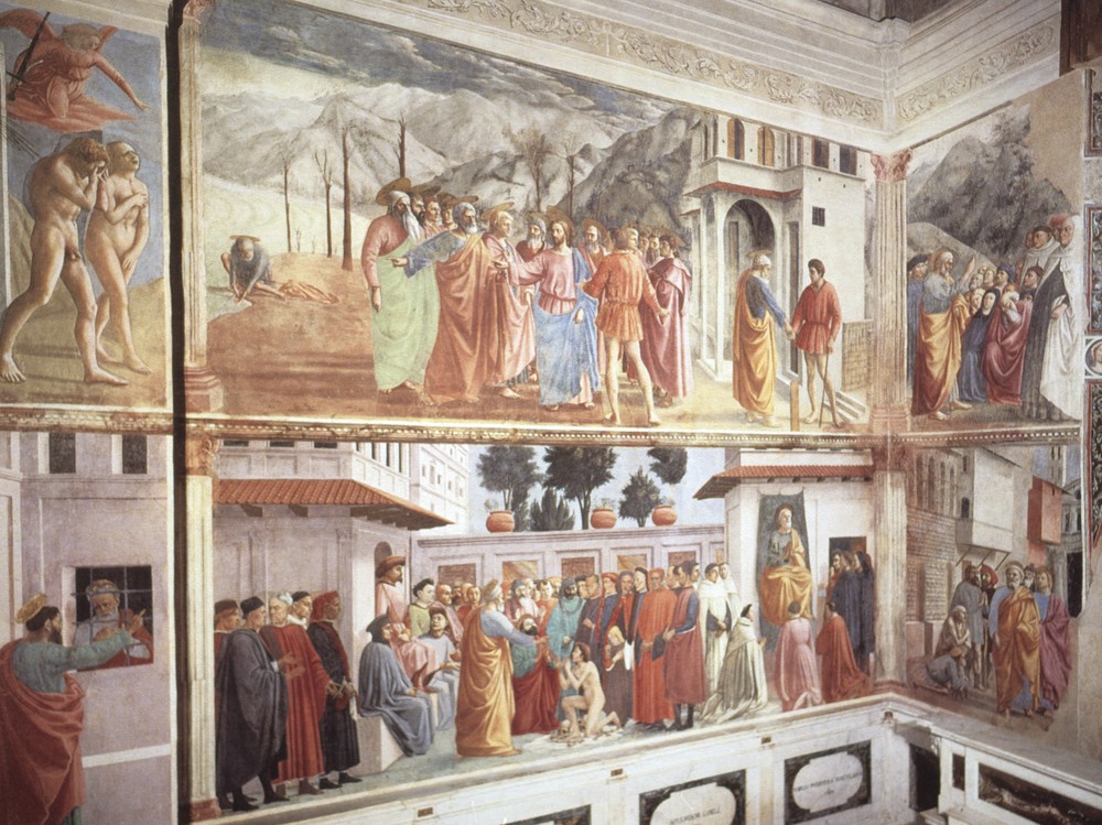
Masaccio: Frescos in the
Brancacci Chapel, Florence
Chris Miller (Early Morning Discussions) commenting on Norris Kelly Smith's Here I Stand: Perspectives From Another Point of View:


Norris Kellly Smith: "It is in keeping with the perspectivist's concern for ethical integrity that they should have been drawn to subjects exemplifying Christ's power to bring wholeness, sanity, and order into the world that perennially lacks just those qualities. This is the burden of Masaccio's frescoes in the Brancacci Chapel which deal with the powerful presence of the man Peter as he brings to bear the force of his authority upon the sicknesses, both spiritual and economic, of the Christian community of Florence"

Miller: Can you imagine such a mural being painted today? High-end Contemporary art is collected by a financial community that has specialized (and profited) from exactly the opposite of economic health.

In the contemporary world, only children's book illustration would suggest "the possibility of a world this lawful, lucid, and intelligible, but only by virtue of our being willing to accept a responsive and responsible position within the order of things"...as Smith feels is presented by Masaccio.

Saturday, March 5, 2011

ALMOST RIGHT, BUT IS SOMETHING MISSING?

"All great cities are a mixture of shopping, culture, and history. Richmond has all of those, and Carytown is a big part of that." Amy Talley, President of the Carytown Retail Merchants Association in the Homes section of the Richmond Times-Dispatch, March 5, 2011.

Monday, February 14, 2011

ALONG THE BANKS OF RICHMOND'S SHOCKOE CREEK


                                Detail of the Market area from the 1879 Beers Map of Richmond. Shockoe Creek can be seen running to the left of the long Market Hall

Today Urbanismo walked the area of the First Market on Seventeenth Street and the Richmond Slave Trail, a poignant reminder of the nefarious trade in slaves that was based in Richmond. A heritage tour  is being developed around archeological resources connected with Richmond’s slave markets.


Market Square in 1793 (north is to the right) 
Markets, since the earliest times, have been placed on the edge of built-up parts of towns, where access by wagons and animals is easiest and the noise and refuse associated with them can be segregated. The Richmond market, and, presumably, the semi-annual fair which preceded it, was placed just beyond the plat where the bottomlands prevented easy settlement, beside the bridge which connected the original town with the newer suburbs on the hill to the west. Over time edge markets are surrounded by shops and fully incorporated into the town.

As we have detailed elsewhere, the city government laid out a formal market square in 1793. It ran between the town and the creek and extended 123 feet to the north and south of Main Street. A two-story brick Market Hall was built in the following year on the bank of the creek on the north side of Main Street. While the market hall survived for many years and has been succeeded by three more structures in the same location, the original market square layout was abandoned as the former commons was laid out in irregular lots and streets over the following decades.


Former trestle extension into Main Street Station


Our winter afternoon walk, one of a series of explorations begun last year, started at the north end of Main Street Station, in a parking lot located between the elevated railroad tracks that split apart to pass on each side of the station. In 1879, this was the location of the Chesapeake and Ohio Freight depot that stood between Broad and Grace streets (see Beers Map below). When Main Street Station was built in 1901, the tracks were carried over the streets on cast iron trestles and the tracks fanned out in this area to allow six locomotives to enter the great train shed which fronted on Main Street and ran back almost to Grace. Franklin Street ran below the station, although this was blocked off when the shed was enclosed in the 1980s. The iron trestles taken from the north end of the station were used to create decorative gates at the new side entrances to the train shed.


1905 Sanborn Map of the area along Shockoe Creek showing the large train shed (1901) in yellow and the long Market Hall of 1855 to the right. Shockoe Creek can be seen running vertically between buildings in the center. The site of Lumkin's Jail is near the angled building in red and yellow northwest of the train shed

The area where Main Street Station was built, west of the market, was a natural one for construction of a massive new structure and for the interstate highway which would later overshadow it. The area along the curving route of the creek was subject to regular flooding. Except for a continuous streetfronts added in the early nineteenth century along the valuable lots on Main and Franklin streets, the banks of the creek were nearly empty. Between Franklin and the James River the creek had been confined to a straight channel running perpendicular to Main Street, but once north of Franklin it wandered back and forth under the steep eastern slopes of Shockoe Hill.


Main Street Station seen from the Seaboard Depot
Freight wing of the Seaboard Depot sen from the northwest
The Seaboard Freight Depot, built in 1909
Where Franklin Street once ran below the great train shed of Main Street station, seen from the west.
A gently rising terrain extended for about two blocks west of Main Street Station. It was once a tightly settled neighborhood of shops, modest houses, and foundries, but is today a parking lot for state employees and the location of the two-story, early twentieth-century Seaboard Freight Depot, fronting on the short stub of Franklin Street that remains intact on that side of the station. A long freight wing extends to the north. The construction of the Richmond Petersburg Turnpike (Interstate 95) in the late 1950s so altered the eastern slope of Shockoe and Council Chamber hills that it is difficult to see their historic form. The elevated highway, wrapping closely around the southwest corner of the station’s ornate tower, also placed much of the area south and west of the station in shadow below the huge concrete highway spans. The earth fill supporting the highway north of Franklin Street creates a steep edge along the valley.


The site of Lumpkin's Slave Jail, marked with stone blocks, lies here beneath fifteen feet of fill

It is in the area of the state-owned parking lots south of Broad Street that archeologists have found foundations of the infamous Lumpkin Slave Jail, one of several dealers that operated on the fringes of the city's commercial center. Much of the slave jail and associated buildings are buried beneath the slopes of fill added as part of Interstate 95. A trail with signage has been developed around the theme of slavery, including the results of the archeological explorations. A larger program of interpretation, including a museum, is planned. Similarly, a large African-American cemetery, abandoned in about 1816, is located below Interstate 95 and to the north of Broad Street.


The area along the creek was mostly residential by the late nineteenth century. The descent was steep from the hill, as can be seen in the postcard shown below, so that the Egyptian Building housing the Medical College was on the edge of the hill, as were the Brockenbrough House (Confederate White House) and the First Baptist Church (later the First African Baptist Church). The land at the bottom of the hill on Marshall Street was parceled out by the city to secondary public buildings, principally the Lancastrian School and the City Jail.
View east along Marshall Street from Shockoe Hill, Online Postcard Collection, VCU Library

The view from the the top of the hill on Broad Street probably looked similarly steep in the early nineteenth century. After Broad Street was extended to the valley in 1845, Shockoe Creek flowed through a narrow bridge under the road. Parts of this still stand, as seen below, although the creek, uncovered throughout the nineteenth century, is now fully underground. The area between the rail tracks was an ideal one for unloading materials. Hungerford Coal and Oil Company is located here. The huge timber bins into which coal was emptied and sorted remain to this day although no coal has been sold since the major flood of 2004.


Stone wall on the south side of Broad Street The stone wall marks the spot where Shockoe Creek passes beneath Broad Street.
Stone abutments on the north side of Broad Street. Rutherford's Row, a continuous line of small
 dwellings described on late nineteenth-century maps as "negro tenements," once lined the north side
 of Broad Street in this area.


Ornamental coping on the top of the walls on each side of Broad Street
Coal unloading facilities at Hungerford. Coal was bagged in the small shed until 2004 
A well-preserved, cobbled section of N 16th St. north of Broad Street, west of the tracks
View looking north from Broad Street under the pylons of the railroad.

The area east of the tracks and north of Franklin Street has been used for parking for many years, but in the early twentieth century it was full of tightly spaced shops. Of these only one large building on the northwest corner of Grace and Ambler (formerly Union) streets remain. This housed Loving’s Produce, a wholesale company, until c. 2008. In 1905, it was the warehouse of the Richmond Branch of Armour and Company meat suppliers.


Loving's Produce Building facade facing Ambler (Union) Street

Continuing with the tour, we visited the area between the Market and Main Street Station. The YMCA Hotel, which corresponds to the French Renaissance detailing of the station in style and material, replaced a block of nineteenth-century shops in the early twentieth century. It sits back from the street to match the setback of the station, permitting a corner view of the market shed. Shockoe Creek once ran uncovered in a narrow straight channel just west of the YMCA Hotel. It then curved to the west and ran under the station. It is now entirely underground.

The Main Street front of the YMCA Hotel Building, east of Main Street Station

Arch or Walnut Alley from the above the path of Shockoe Creek looking east to the existing Market Shed

Early buildings between the Market and the railroad station relate to the market function of the area. include the fine, three-story commercial building on the northeast corner of Seventeenth and Franklin streets. The one-story Acme Tomato Company Building, dating from before the Second World War, occupies the space between the three-story building and Main Street Station. 
The well-preserved three-story commercial building with the Acme Tomato Co Bldg.  beyond

The desert-like parking area north of the market bore the brunt of the 2004 flood, which washed
 away much of the paving. It was, however, the site of a full block of shops in the early twentieth
 century, of which the Loving's Produce Building is the only remaining example.
Here we ended our tour of the fragmentary urban tissue along Shockoe Creek with a visit to Havana '59 for some much needed refreshment.

Saturday, January 8, 2011

Concinnitas, or Beauty Reconciled

What does Alberti mean by concinnitas? How does he learn what it is so that he can introduce it into his building? and what role, then, does concinnitas play in investing a building with beauty?

Concinnitas, Alberti’s powerful term for “the absolute and fundamental rule of Nature” denotes, with such a description and by its very nature, a difficult, and illusive theory. While Alberti makes no more specific statement than that concinnitas composes parts “according to some precise rule,” the very framework in which concinnitas is conceived will help the thoughtful architect, philosopher or political thinker in its pursuit, for concinnitas is more than a mere pattern book rule to be followed. Rather it is the way in which Beauty is reconciled to the particular example on earth. Concinnitas translates the ineffable idea of Beauty to us through minute adjustment of proportion, thereby rendering it perceptible to the senses. The pursuit of concinnitas is the highest goal of the architect, or indeed of man in general.

“Everything that Nature produces is regulated by the law of concinnitas, and her chief concern is that whatever she produces should be absolutely perfect.” Concinnitas flourishes in birth and death, in creation and destruction, and in every changing state between these extremes. Indeed, there can be no written formula for such an idea because it is not a static result, but a defining action whose very meaning is to take parts which are in every case different, and arrange them such that they form through their correspondence a complete and perfect whole. Concinnitas is the final and defining quality of architecture, or art in general. As such, it surpasses the crude necessities of shelter and protection, enters the realm of beauty, and becomes something that arouses delight in the beholder.

Thus, a discussion of concinnitas must begin with the understanding that it is something which governs both the practical and aesthetic qualities of building; it is behind and above decisions concerning the material or order of building. What Alberti is telling us is that no truly functional thing can be made without concinnitas, and that any discussion of concinnitas must therefore govern and surpass that of firmness and commodity. Architecture, Alberti tells us, in agreement with Vitruvius, is worthy of praise when it is commodious, firm, and delightful. Yet for Alberti, the final requirement is the most vital. “Of the three conditions that apply to every form of construction – that what we construct should be appropriate to its use, lasting in structure, and graceful and pleasing in its appearance – the first two have been dealt with and there remains the third, the noblest and most necessary of all.” In other words, firmness and commodity are necessities not just of a palazzo, but also of a barn. What sets great buildings apart is that they delight our senses with the beauty arising from their proportions, not just relative to themselves, but to the cosmos.

“All care”, he tells us, “all diligence, all financial consideration must be directed to ensuring that what is to built is useful, commodious, yes – but also embellished and wholly graceful, so that anyone seeing it would not feel that the expense might have been invested better elsewhere.” Thus, architecture for Alberti is most concerned with beauty, in that every good which architecture brings to humanity is a result of its grace and appropriateness. “To have satisfied necessity is trite and insignificant, to have catered to convenience unrewarding when the inelegance in a work causes offense.” The task of the architect is to reach beyond necessity and evoke pleasure in the viewer. This is accomplished through concinnitas.

Central to Alberti’s theory of concinnitas is the idea that architecture is a composition of various individual parts that follows a rational arrangement. Beauty, Alberti tells us, “is that reasoned harmony of all the parts within a body, so that nothing may be added, taken away, or altered, but for the worse." It is in the correct manipulation of these elements that beauty is achieved. “When you make judgments on beauty, you do not follow mere fancy, but the workings of a reasoned faculty that is inborn in the mind… for every body consists entirely of parts that are fixed and individual; if these are removed, enlarged, reduced, or transferred somewhere inappropriate, the very composition will be spoiled that gives the body its seemly appearance.”

The theory of concinnitas is grounded in a perfect composition of the various parts. If these elements such as cornices, windows, walls, columns, doors, and porticoes are altered from their perfect manifestation in the whole, concinnitas will no longer be present in the work. Indeed, one might also say that, just as a “reasoning faculty is in born in the mind,” so too a “natural excellence” exists as a potential in every building. The individual building in this description already exists as a perfect idea which the art of the architect attempts to emulate. In other words, a failure to correctly arrange the parts according to the rules of concinnitas regulating the composition of the whole will results in an unsuccessful building, or one that does not attain the perfection it is innately capable of.

How then do we achieve this proportionate arrangement? If beauty is the reasoned harmony of all the parts, then that harmony may be described, Alberti tells us, using Number, Outline and Position. For Alberti number was a quantitative relationship between things in a formula, but more importantly, it was also a qualitative entity in its own right. As George Hersey so beautifully explains, there were whole churches, cities, kingdoms and heavens of numbers, each with its own particular character and even genealogical structure. Outline is difficult to understand as it can mean several things. I believe it is directly tied to Alberti's idea of lineamente, or the lines and angles, which form the building (as opposed to the material, or structura). Regardless, it is something like the form, or type of the building, in that in the outline informs us of the building's purpose (to some degree this is also accomplished by ornament). Branko Mitrovic has called lineamente shape, which I think is not far from the truth. Position has to do with Alberti's use of the term collocation, or the placement of the parts of a body in such a relationship that the whole, which they form, has the quality of beauty. We will return to this.

“But,” Alberti continues, “arising from the composition and connection of these three is a further quality in which beauty shines full face: our term for this is Concinnitas; which we say is nourished with every grace and splendor. It is the task and aim of concinnitas to compose parts that are quite separate from each other by their nature, according to some precise rule, so that they correspond to one another in appearance.” In other words, concinnitas takes varying numbers of things which have different shapes, and lie in various positions, and creates (according to a “precise rule”) a complete and beautiful whole.

Concinnitas is not simply the combination of number, shape, and position, or a glorification position only, it is rather the manipulation of the three qualities such that each is altered to form a suitable and distinct whole, appropriate for its unique location and purpose on earth. To make this distinction more apparent, let us even say that position is sufficient to compose a literal version of a building’s heavenly counterpart, but that concinnitas breaths the life into an otherwise inanimate copy. Concinnitas fractures the perfect harmony of ideal beauty just enough for man to comprehend it. In short, concinnitas is like the bending of a perfect rectangle to fit the curvature of the globe it would otherwise be incompatible with.