“First, What kind of life was lived in this place, that is, Why and how did its builders build as they did?
And second, what rules with general validity and applicability did they follow?”
Carroll William Westfall, Learning From Pompeii.


Showing posts with label Shipping. Show all posts

Sunday, May 29, 2016

Richmond, Virginia's City Docks: Antebellum Gateway to the City's Commerce


Richmond's City Docks, completed between 1816 and 1819, were a significant feat of engineering that provided the city with a large body of quiet water unaffected by tides, high water, and most storms, and that was accessible by ocean-going boats.
This important civic improvement helped Richmond maintain its place as one of the world's sources of fine flour and tobacco. Both were renowned for their quality and shipped around the world. Part of the City Docks still survive near the Great Ship Lock Park along the route of the present-day Kanawha Canal tour boats.


The Old Dock at Liverpool (1709-1715), shown in 1723, protected from the tides by wooden gates, was built to the designs of engineer Thomas Steers. It was the first commercial dock [http://en.wikipedia.org/wiki/Old_Dock].
A dock in contemporary British use was an enclosed area of water created by enclosing a natural tidal pool or stream mouth with an embankment or by excavation. When the level of water was controlled, it permitted quicker turn-around of cargo and dramatically increased the potential volume of trade.  Such docks had  first appeared in Britain with the opening of Thomas Steer’s Dock (the Old Dock) in Liverpool in 1715. This dock, key to the city’s commercial success, was the world's first commercial wet dock, It was provided with gates at the entrance to keep the water level  and protect ships as they were loaded and unloaded. The dock was surrounded by warehouses and could hold as many as 100 ships.


Detail of 1738 plan of Town Dock, Boston, Mass., Boston Public Library.
The idea caught on in the colonies. Boston, Massachusetts had a “Town Dock” provided with a wharf next to the market as early as 1738, created by partially enclosing an inset known as Bendell’s Cove.


https://en.wikipedia.org/wiki/Port_of_Hull#   Maps showing the Old Dock in the city of Hull (1774) and later interconnected docks opening off the River Humber.

West India Docks: this engraving was published as Plate 92 of Microcosm of London (1810). It shows one side of one of the three large docks, lined with ships and five-story warehouses [http://en.wikipedia.org/wiki/West_India_Docks].
In 1773, the Corporation of the City of Hull and city merchants organized the "Dock Company" on the east coast of England. An act of Parliament gave the Hull organization authority to raise capital, making it the earliest dock company in Britain permitted by statute. Soon after, Georgian London and other British ports were marked by the expansion of docks, many of which  were surrounded with walls to prevent theft of goods.


The Richmond Dock Company

As Richmond’s position as a center for manufacturing and trade improved in late eighteenth century, conditions for shipping and warehousing goods remained primitive. At early eighteenth-century Richmond, a miniscule port in comparison to Boston, small boats had long been accommodated at the well-known Rock Landing, located on the upstream side of Shockoe Creek just below the falls. Boats probably also could land behind the shelter of Chapel Island in the old channel of Shockoe Creek, which was reserved for the use of citizens as the “commons of the city.” The principal deep-water port was at Rocketts, immediately downstream from the city.


The Byrd Plat of 1737 shows Shockoe Creek (the narrow creek to the left of the town) flowing parallel to Cary Street, following the channel that would later be enclosed and edged with a stone embankment to form the City Dock of Richmond.


Young’s Map of Richmond, 1809. The map shows the mouth of Shockoe Creek near the west end of Chapel Island at the Rock Landing, the highest point where boats could land in the period before the construction of the City Dock. Here, boats were loaded with tobacco from William Byrd’s warehouses, located on the west side of the creek, beginning in the 1720s. The 1737 section of the city seen above is to the right side of this image.
Richmond’s smooth functioning as a port was foremost in the mind of the Virginia General Assembly when it adjusted and expanded the rules governing the trustees of the town in 1773. The first duty of the trustees was “to meet as often as they shall think necessary for appointing a public quay, and such places upon the river for public landings as they shall think most convenient, and if the same shall be necessary, shall direct the making of wharfs and cranes at such public landings for the public use” [An Act, to establish and enlarge the power of the trustees of the town of Richmond, in the county of Henrico, and for other purposes. March, 1773, Ch. 6, 8 Stat. Lar. 65.5.] 


In 1780, the same patterns held: access to the Rock Landing, referred to variously as the “Shockoe,” “upper,” or “Warehouse” Landing, “much obstructed of late by freshes, and by the natural course of Shockoe Creek being altered”  by banks of sand “which, if not quickly removed, may render the navigation to the upper landing useless” for the profit of both the citizens of the town and the agricultural producers of the back country, was to be reopened by a company authorized to raise private investment for that purpose [An Act, for locating the Publick Squares, to enlarge the Town of Richmond, and for other purposes. May, 1780]. After the opening of the James River Canal in 1790 expanding the potential for shipping through the city, the limitations of the arrangements for loading the produce directly onto ships became increasingly apparent.

John Williamson, Part of plan of the city of Richmond embracing lots in basin of James River Canal and adjoining lots, 1793. Board of Public Works, Library of Virginia. This shows alternate paths for the canal to the new basin below Shockoe Hill and the steep outfall, not long before it was utilized as a power source by the Haxall Mills.
 The James River Company, chartered in 1785, ensured that tobacco, iron, coal, wheat, stone, lumber, and pork from the plantations to the west could be brought by boat directly into the heart of the city at the Great Basin. The canal permitted direct transport around the Falls of the James River for the special cargo boats called "batteaux". All produce that was brought around the falls was unloaded here and placed in warehouses, from which it could be taken by wagon through the city to the wharves downstream where larger ships could be tied up.

Addition of a great canal basin in 1793-95 had not only provided a location for shipping warehouses and wharves, but also supplied water to what would soon become a series of huge merchant flour and lumber mills, beginning with the opening of the massive Haxall Flour Mills in 1798. These produced fine white flour transported around the world as a result of an increase in wheat production in competition with tobacco in the areas west of Richmond.    


In 1816, flush economic conditions at the close of the war with Great Britain encouraged the city to consider improving access by sea-going ships, most of which at this time anchored just downstream at the city seagoing port of Rockets. Direct transfer by water of the city’s flour and tobacco products could only be assured by the creation of an artificial harbor or wet dock.

In the European tradition of building sheltered docks to foster water transport, the Virginia Legislature passed a bill in 1816 permitting James River to be cleared from Rocketts as far as Mayo’s Bridge, and to admit boats into Shockoe Creek and as high in the river as Haxall’s Mills [Christian 93]. At this time Ariel Cooley, a canal builder from Springfield, Massachusetts, who had been involved in developing navigation along the the Schulkyll in Philadelphia, was engaged to make locks between the basin and the river. According to Samuel Mordecai, he underestimated the power of the water that he set loose to open a channel to the river and the 13 rubble stone and wooden locks and gates for which he was paid $49,000 were so poorly made that they were sealed shut. New stone locks were opened in 1854 [Mordecai, Richmond in Bygone Days, 1856, 235-6].

The Richmond Dock Company opened its books to investors that same year, 1816, a year of great economic excitement in the city. The city’s Common Hall purchased 1,000 shares in the company at a cost of fifty dollars per share. The dock appears to have been completed by 1819. Although the original vision of the James River Canal had been to link the canal terminus at the basin between Eighth and Eleventh Streets with the tidal river and the sea, this was not accomplished right away. The north-south streets of the city were extended south to the docks and a row of new squares laid out on the former city common, suitable for the construction of warehouses on the edge of the wharf. These were named for local and national figures such as Byrd, Washington, Franklin, Carrington, and Henry.


Detail, Plan of the Richmond Docks and James River from Rocketts to Warwick, 1818, Virginia Board of Public Works, Library of Virginia. The design for the new city dock is at the top and the port of Rockets at the bottom.  Mayos Bridge can be seen crossing the basin on its way to the south. Shockoe Creek appears to run under the basin and 18th Street passes over it.  The lower lock is parallel with 24th Street. North is to the right. The plan varies somewhat from what was built.
The new City Dock was laid out by an expert in canal construction who was personally familiar with the latest developments in British dock design. It was designed by the Board of Public Works’ Principal Civil Engineer Loammi Baldwin, Jr. (1780-1838). Baldwin was the son of Loammi Baldwin (1744-1807), an important early figure in American civil engineering and especially canal building. He designed and built the Middlesex Canal in Massachusetts between 1794 and 1803. Loammi Baldwin, Jr. assisted his father with the Middlesex Canal and soon after 1807 traveled to England to view public projects. He was active in Virginia between 1817 and 1820. The plan seen here was prepared by Baldwin in 1818 for the Board of Public Works shows the dock before construction began.  The dock consisted of two basins fed by a “feeder” from upstream and a canal to the south that entered the river by a series of locks. The was created by placing earthen embankments around the former route of Shockoe Creek on the north side of a strip of land known as Chapel Island, but originally connected at it west end to the north bank of the river.  Three basins, Upper, Middle, and Lower, were extended to the east and west with canals connecting to the Haxall Mill race above and the James River Below. A great deal of fill was required to extend the main dock basins out into the river in front of the old Rock Landing.


Young’s Map of c 1817 showing the proposed canal locks (at bottom center left) connecting the Upper, Middle, and Lower Basins of the City Dock (seen at left) with the Haxall Mill Canal, bringing water into the docks and permitting access to the flour production of the city’s principal mill. The old (curved) and new (straight) paths of Shockoe Creek are both shown.

This proposed design for a new, larger dock between Mayo’s Island and the existing dock involves adding a new locks [one is shown at right]. The drawing documents the existing City Dock, the locks leading to the Canal Basin, and Mayo’s Bridge (and its bridge over the canal) in detail. North is to the bottom.  [Survey of the James river between the dock and the island, Virginia Board of Public Works,1829, Library of Virginia]. North is to the bottom of the drawing.

Detail of the City Dock as built showing how Shockoe Creek entered directly into the dock basin (bottom center) but was provided with a spillway on the opposite side for overflow during high water. [Survey of the James river between the dock and the island, Virginia Board of Public Works,1829, Library of Virginia].
The James River and Kanawha Company
The state assumed control of the James River Company in 1820. The James River and Kanawha Company, organized in 1835 to connect the trans-Appalachian West with the Chesapeake Bay by means of a canal, took control of the canal above the falls at Richmond. The canal was extended to Lynchburg in 1840 and the Valley of Virginia in 1851.  The canal scheme was under constant pressure to expand the access for both shipping and water power below the falls. The Virginia Board of Public Works undertook a study for another unexecuted enlargement of the docks in 1836 to accommodate as many as 120 ships in a great new dock beside Mayos Bridge. This dock, protected by an earthen wall, was kept filled by ponding the entire river behind a dam that extended across the river parallel to 16th Street. A wide ship canal led from the south side of the pond to enter the river at Warwick, where the river allowed passage for ships of greater size. The plan for a ship canal was never executed.

The canal was enlarged in several stages, from an average initial depth of 3 1/2 feet and width of 40 feet. The canal as far as Lynchburg and including the portion running through the city, was expanded in the late 1830s to five feet in depth and fifty feet in width. Water management and sufficient supply remained a contentious factor between the canal company and the manufacturers who leased the rights [Michael Raber et al., Historical and Archeaological Assessment, Tredegar Iron Works Site, Richmond Virginia, report for the Valentine Museum and Ethyl Corp, 1992].


 Detail, Map and Profile of a Ship Canal from Richmond to Warwick Being the Proposed Plan for the Connexion of the James River and Kanawha Improvement with Tide Water, 1841.  Virginia Board of Public Works. Library of Virginia.
In 1841, the canal company purchased the Richmond Dock Company’s property. New plans drawn up in 1841 called for a new canal to run from the arsenal along a new embankment at the river edge, bypassing the old basin and suggesting that the north side of the river would be extended far enough to the south to encompass Mayo’s Island.  This was never executed.


Map of Part of the City of Richmond showing the James River and Kanawha Canal, 1841, Board of Public Works, Library of Virginia. A proposed route for a branch of the canal is through Mayos Island.    
Instead, the canal company improved and enlarged the city dock to accommodate larger ships by 1845. The ship canal was lengthened and the lowest lock moved east to 26th Street. From 1849 to 1851, the dock was greatly enlarged, five granite locks replaced the old wooden locks in a line paralleling Canal Street up the steep hill to the Great Basin of the canal (the fourth and fifth survive in place). Turning basins were added between 9th and 14th streets; the Great Ship Lock was built further east of the dock, in line with 28th Street, between 1850 and 1854. The new facilities greatly improved transportation to and from the city.  Between 1855 and 1860, the Richmond Dock Company reported that the number of vessels leaving the dock increased from 1,377 to 2,337, including packets for New York, Boston, and Baltimore.

Mijacah Bates’ Map shows the form of a portion of the City Dock in 1835., including the entry lock next to 26th Street. Comparison with earlier maps indicates that the original ship canal ended in a lock at 23rd Street, where the canal widens. This map makes it clear that the canal was lengthened and the ship lock rebuilt between the initial construction and the rebuilding about 1850 (see below).


Map showing the fully developed City Dock complex of pools, locks, drawbridges, and basins just before the Civil War [Adams, I.H. Map of the City of Richmond, Virginia, 1858, published 1864].
As part of the new design, Shockoe Creek can be seen to pass in a culvert beneath the canal. The former site of the Rock Landing is where the Gas Works is shown. At about this time, the area at the north end of Chapel Island as far as the mouth of Shockoe Creek was expanded into the river. It incorporated a small island called Mayo Island and Toll House Island on the Board of Public Works plans of 1818 and 1829, as well as the riverside ground occupied by the Vauxhall pleasure garden. The edge of the reclaimed land was protected by a substantial granite embankment and housed the Richmond and Danville Railroad yard and terminal.


New warehouses were built into the bank beside the renovated stone wharf of the City Dock, beginning in the mid-1840s, to receive goods and produce. In particular, a series of fourteen large brick warehouses was built between the dock and Cary Street, just as in other urban docks, by a private investor, John Enders, for lease or resale to others. The three that were used for the famous Libby Prison were at one end of the long block, most of which burned soon after they were built. Enders and Gen. J.B. Harvie were active in the building of the dock. Other warehouses and tobacco factories were constructed on nearby blocks, which was transformed into an industrial district. When, after 1880, the train replaced the canal along the north bank of the river, the industrial tissue was renewed on a larger scale with the long row of tobacco factories filling the squares between Main and Cary Street.

Libby Prison (one of Enders Warehouses) and the City Dock from Benson J. Lossing. Harper’s Encyclopedia of the United States, vol. 7, 1912.

Detail, A. Hoen and Co, City of Richmond, Virginia from Manchester ,1876. A range of boats in various positions are seen behind the embankment of the City Dock. The gap towards the right is the outflow of Shockoe Creek during periods of high rainfall [Valentine Museum].

Enders Warehouses in the City Dock after the Civil War.

This view from Harper’s Magazine in 1863, shows the dramatic slowdown in traffic during the war years. Mayos Bridge and the mills are seen in the distance.
 

Another view of boats pulled up at the wide wharf along the north side of the City Dock also shows the line of warehouses to the north and the vast mill structures to the immediate west [Richmond Quay, London Illustrated News 1862].

The Virginia Steam Sugar Refinery was opened at 17th and Dock Street on the City Dock in 1860. Boats, both steam- and sail-powered, are seen taking on cargo in this advertising card published many years later in a city paper, c. 1938.

Detail, Beers Map of Richmond, 1876. Mayo’s Warehouse is seen here next to the railroad depot.

The City Dock in the late nineteenth century, showing a sea-going ship and the revolving bridge that carried 17th Street over the canal [City on the James, 1893].


This illustration shows the opposite end of the 17th Street bridge and the railroad depot that was built on added fill between the river and the dock. It permitted the ready movement of goods between ships and trains [City on the James, 1893].
With the closure of the canal in 1878, the City Dock was acquired by the Richmond and Alleghany Railroad. The railroad later sold it to the William R. Trigg Company, which developed a ship-building industry along the south side of the dock on Chapel Island. The Trigg Compnay specialized in the building of boats for industry and of torpedo boats and destroyers for the government, which they launched from the side into the canal. The company employed two thousand workers and occupied as much as a mile of the ship canal. After the death of William R. Trigg in 1902, with three boats under contract, the business failed and the company went into receivership. The city acquired the dock facilities east of Seventeenth Street in 1912, built new warehouses, and attempted unsuccessfully to re-establish the city as a major port [Mordecai, John Brooke in Richmond, Capital of Virginia, 1938, 274-275, 283-284].  


View on board deck of USS Dale while bring outfitted at Trigg Shipyard, 1902 [Naval Historical Center]. The three-masted schooner John S. Beacham is on the other side of Dale. They appear to be located below the Great Ship Lock.


Launching of a destroyer at the Trigg Shipyards [VCU Library]. The launching of the USS Shubrick in 1899 brought President William McKinley to Richmond.


Saturday, July 5, 2014

TALKEETNA, ALASKA: "WHERE THE ROAD ENDS, LIFE BEGINS"

Talkeetna, Alaska, has been many things: supply station and winter base for prospectors, miners, and trappers in the area around Cache Creek, a port for riverboat shipping, and a  railroad depot on the Alaska Railroad midway between Anchorage and Fairbanks. It is located 85 miles above the sea at the head of shipping on the shallow Susitna River. Today it has attained new significance as the primary jumping-off point for climbing expeditions to the summit of Mount McKinley in the nearby Alaskan Range. The development of the town’s story is wrapped up with the transportation history of the remote Alaskan wilderness. It involves foot travel, water transportation, dog sled, horse, rail and airplane. 

Remarkable view on July 3 of the summit of Mt. McKinley, usually concealed by clouds.
Main Street looking west from the Town Park with Nagley's Store at center.
A recent visit to the unincorporated town of Talkeetna (pop. 876) revealed remarkable continuity of form between the early Alaska railroad town and the tourist depot that it is today. The town is made up of a Main Street that extends from the station to the river, paralleled by Front Street to the north and First and Second streets to the south. It is crossed by streets named A, B, C, and D. Flooding and erosion have reduced the town by two blocks to the west, but what remains shows the kinship of Talkeetna with planned towns around the world. Information here is derived from exhibits at the Talkeetna Historical Society and the National Register form for the Talkeetna Historic District.

David Lawrence Cabin (c 1920)
Prospectors arrived as early as 1896 with a gold rush in the area around the Susitna River. The tiny port of Talkeetna was established by the Alaska Commercial Company in 1910, soon after the discovery of gold on nearby Cache Creek in 1906. It served as a supply center for miners who spent the summers on their claims and the winters hunting and trapping. The supply center closed in 1912, but the town’s use as a home base by miners in the Yentna District lasted until the end of the mining era during World War II. 

In 1916, the Alaskan Engineering Commission, a federal agency responsible for building a railway to open up the interior of Alaska to development, selected Talkeetna as the location for a construction headquarters, station, and post office. With the completion of the railroad in 1923 the town lost a significant section of its population, but its purpose as a supply center was sustained. From 1920 to 1932, the Alaska Road Commission maintained a road crew in Talkeetna, building and repairing 22 miles of wagon roads and nearly the same number of miles of sled road giving access from the depot to the back country all around.

Map from the National Register form for the Talkeetna Historic District [National Park Service]

The AEC used its authority to plat a grid of eighty lots in 1918 and sold them to merchants, freighters, and miners. The town previously consisted of informal lots flanking a route running back from the river landing. Many occupants were able to establish “preference rights” to purchase approximately half of the lots since they had already made improvements to them. In 1920, the population included 53 men and 17 women. 19 of the men were miners, 5 were trappers, 7 worked for the railroad, and 22 were involved in commerce. 

The main intersection and the commercial center (at least since the loss of the western end of town to erosion in the 1940s) is found where Main Street is crossed by D Street. One corner is occupied by a triangular park, probably established by the Alaskan Engineering Commission in 1918 as a site for the rail-related buildings. Such parks were commonly included in post Civil-War town developments in order to allow for additional railroad buildings and to impress visitors by ordering and ornamenting what would serve as the gateway to the town. 

When the 30-foot-wide Talkeetna Village Airstrip opened in 1938, it was positioned immediately adjacent to the town as a continuation of D Street, so that airplanes could readily load supplies from the trains and take off directly over Main Street. This new transportation center may partially account in part for the importance of the intersection of D and Main streets.       

Fairview Inn, Talkeetna, (1923), view from intersection of Main and D streets on July 3.

Not until 1964 was Talkeetna connected by road with the outside world. The streets were unpaved and the buildings fronted directly onto the streets, probably with boardwalks in heavily traveled sections. A section of boardwalk has been maintained in front of Nagley’s Store. The rough and even primitive character of the edge between lot and street is what gives the town its peculiar historic atmosphere. Although the streets have been paved, the lack of sidewalks and presence of wildflowers and native shrubs give the sense of continuity in time and place.   

Street edges in Talkeetna

Ole Dahl Cabin #1 (c 1918)

Nagley's Store (1920/1945)
Of the thirteen historic buildings built between the late 1910s and the 1930s, most are located along the Main Street. As a town with limited functions and restricted demographics, the number and variety of civic and other specialized buildings was limited. There was no school until 1936, when the Alaska Territory built a one-room school house (now the town’s museum). There was no church and the only public building for many years was the railroad station. The Fairview Inn, the only hotel, was built between 1920 and 1923. It stands across the street from Nagley’s Store, built by Horace Nagley out of reused parts brought in by barge in from an older supply station about 1920. It was relocated in 1945 from the lower part of town after it was threatened by erosion of the river bank. 

The Frank Lee House (1917), known after 1940 as "the Talkeetna Roadhouse," a longtime headquarters for Mt. McKinley climbers, located on the corner of Main and C streets.
Detail of logs at the David Lawrence Cabin
All of the early buildings, other than the depot and the Fairview Inn, were built of logs. Many of these have v- and square-notched corners that are protected by boxed corner boards. A two-story, gable-front log house was built in 1917 on the corner of Main and C streets by Frank Lee, a river freight operator. At 21’ x 32’ feet, it is one of the largest. It was converted into an inn and restaurant (“the Road House”) in 1940. Other houses include the small and low-ceilinged (13’ x 20’) typical “trapper’s cabin” built by Ole Dahl about 1918 and the David Lawrence Cabin, which measures 15’ x 20,’ and the second Ole Dahl House of c 1920, which was built after his marriage and measures 20’ by 26.’ By the 1930s, houses continued to be built of log, but were supplemented by frame buildings like the school. 

Tuesday, February 12, 2013

The Custom House: Richmond's First Federal Building


Architecture in the City representing the Federal Government 

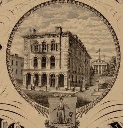
The federal presence was manifested in the capital city of Virginia just before the start of the Civil War by an impressive, permanent granite building. After years of using rented or borrowed accommodation for federal officials, the U.S. Government eventually provided antebellum Richmond with yet another special building type new to the city and a further clarification of the city's urban scale. It was located on a key site in the civic plan that helped, by its relative position, to clarify the constitutional relationships of state, local, and Federal elements in the overall polity. By means of its kinship in form and material with similar buildings built by the federal government across the nation, it clarified its unique position in the Virginia capital. 

The Tariff Act of 1790 set up a system whereby tariffs were collected on imported goods at all ports of entry. Tariffs provided the largest source of federal revenue until the introduction of the income tax in 1913.  The American government began building architecturally distinguished custom houses in the early nineteenth century. They were primarily intended to house the officials who regulated the export and import of goods and collected customs fees on imports. The officials had formerly been accommodated in warehouses where the goods were kept.


These were modeled on British customs houses and commissioned for major centers of shipping. Places in which to collect customs at ports of entry had existed since medieval times. One of the earliest purpose-built custom houses standing in England is the Exeter Custom House, designed by Richard Allen and built between 1680 and 1681 and. With its originally open, arcaded first floor, the five-bay brick building resembles a town/ market hall. It has an elaborately plastered “long room” on the upper floor and an earth-floored “strong room” on the lower level. Wren’s post-fire Custom House in London of 1671 and its successors of 1717-25 and 1813-17 were architecturally impressive landmarks on the Thames, each containing a “long room” on the main floor where duties were paid [[http://www.hm-waterguard.org.uk/Offices%20&%20Buildings-England.htm]. 

Christopher Wren’s London Custom House of 1671  [http://www.hm-waterguard.org.uk/Offices%20&%20Buildings-England.htm]
The busy Long Room in the London Custom House, where ships were reported 
and duties were paid on goods c. 1750.
The expanding federal court system needed space in the city as well. Under the Judiciary Act of 1789, each state had a district court in which a judge heard cases involving admiralty and maritime law and minor federal crimes. More important federal cases were heard circuit courts, which met in the same districts, served by two (later one) Supreme Court justices and the district judge. This system continued largely unchanged until after the Civil War. 

In Richmond, federal officials were indifferently housed for many years. Customs officials had for many years been located in a warehouse on Fifteenth Street. The post office had been located in a series of buildings, including the former museum building on Capitol Square and the Exchange Hotel. By the 1840s, Richmond's customs officials were housed in a three-story brick building on Fourteenth Street between Man and Cary, near the City Dock [Virginia Mutual Policy 12610, 1844]. 

An earlier Richmond custom house (Building A) was located in a three-story brick commercial building shown second from the corner on the west side of Fourteenth Street (north is at the top) [Virginia Mutual Policy 12610, 1844]

Interestingly, like their British predecessors, American custom houses drew on the long-established tradition of market halls and courthouses. And, unlike the earlier brick and stucco-clad masonry civic buildings of most local and state governments, the new federal buildings were the first in their neighborhoods to be clad in expensive and permanent cut stone. Like other civic buildings in the period, the more important mid-nineteenth-century custom houses employed fully developed classical forms, but in smaller cities the use of the orders was restricted to the entablature. These "market hall" inspired buildings frequently employed arcades as a principal exterior feature and utilized an fashionable Italian idiom for cornices and architectural details. 

In the antebellum period, the central government commissioned a series of significant new custom houses in major cities, designed not only to provide a dignified setting for the functions of the national government and to enable the effective regulation of international commerce, but to house other federal functions, such as courts. 


Bank Street façade of the Richmond Custom House, 1865 [LOC] 


The Richmond Custom House

 Supervising Architect of the Treasury Ammi Burnham Young produced the design for the Richmond Custom House in 1858, as he did for all the federal buildings built between 1849 and 1860. Most were intended to be fireproof and were built of granite. The floors were supported on brick segmental arches spanning between cast iron interior structural members, using recently developed building technology widespread by 1850 [Sara E. Wermiel. The Fireproof Building, 2000]. In most cases the first floor contained a post office, the second floor held the customs office, and the third floor housed a federal courtroom. Young chose a modern, astylar Italianate manner for the form and detail of the custom house.

As mentioned above, custom houses had, since the eighteenth century, been modeled on market halls, often with lower-story arcades and upper-story offices. As the building type increased in significance 
as a local representation of the national government, custom houses in the largest cites also took the form of palaces or temples, sometimes including a central dome and a colonnade or pedimented portico. Among Young’s designs, however, the level of architectural expression was scaled to the size and importance of the host city. All the Virginia custom houses, even the most elaborate, retained the architectural imprint of the market hall. In each design, the separation of functions was maintained by the provision of distinct entrances to each from the exterior.


The Custom House in Norfolk, Virginia. Architect, Ammi B. Young, 1858 [LOC].
Norfolk, as a major port, had received its first formally designed custom house in 1819.  Norfolk’s new custom house of 1858 took the form of a Corinthian temple, but, like a classical market hall, stood on a raised basement with regularly spaced entries. The Richmond Custom House, at a smaller scale appropriate to the city's status as a port, retained the market-derived arcades in the forms of an arched loggia fronting on Main Street and an arcaded porch on Bank Street. 
The Custom House in Petersburg, Virginia. Architect, Ammi B. Young, 1856-58 [LOC].
Similarly, Petersburg’s Italianate Custom House, completed in 1858, had an arcaded ground floor. Two doors in the arches on the north front gave access to a post office vestibule, while the third opened onto the stair to the custom house office. There was no courtroom in the Petersburg building, but a third story containing sleeping apartments for the officials was added to the iron-framed, granite-clad building during construction [HABS documentation]. A small public piazza in front of the Custom House was enclosed by an ornamental cast iron fence and paved with "North River flagging" and flanked by "grass plots, ornamented with trees" [Petersburg Daily Express, 22 Dec. 1858, 1, quoted by HABS].
The Custom House in Alexandria, Virginia. Architect, Ammi B. Young, built 1858, enlarged c 1903, and demolished c 1930 [LOC].


The Alexandria Custom House located close to the street on its public square at the corner of Prince and St. Asaph streets on 1885 Sanborn Map
The Alexandria Custom House of 1858, containing also the post office, and U.S. district court, was even smaller, but featured attached pilasters and a full entablature. Each of the Virginia custom houses was conceived as a free-standing civic building at the urban scale and was placed on an expansive public lot with room for expansion. Richmond’s custom house was set apart from the commercial buildings along Main Street by a pair of flanking courtyards shielded by cast-iron fences and gates. The post office was on the first floor, the customs offices on the second floor, while the third floor held the federal courtroom.


Beers' Map of 1877. Detail Showing Capitol Square with the Custom House directly south of the Capitol. The site of the City Hall of 1816 is shown north of the Capitol as a public square.

The Richmond Custom House’s position as a special building at the urban scale was as carefully composed as were those of Richmond’s other civic buildings. The City Hall of 1816 stood almost directly behind and facing the north façade of the Capitol, making a powerful alliance between the life of the city as state capital and as metropolis. The federal relationship was even more effectively expressed by placing the custom house fully on axis with the Capitol’s south front, along the bottom edge of Capitol Square (see the 1858 drawing below). City Hall was located on busy Broad Street, the city’s principal thoroughfare, and the custom house was allied with, but separated from, the city’s banks and stores in Main Street’s commercial center. The custom house and post office facade was aligned with the commercial streetfront, while the courthouse front was set back as befitted as civic building.

While the post office was directly accessible to its many clients along Main Street, the entrance to the federal court faced the Virginia legislature from the foot of Capitol Square. The Richmond Custom House was effectively terraced into the hillside at the foot of Capitol Square, so that it appeared to be only two stories in height on its northern front. A balustraded retaining wall across the north edge of the lot permitted below-grade windows in all the first-floor rooms.  


Main Street façade of the Richmond Custom House of 1858 
[Beers Atlas 1876]. 

Enlargement and Expansion

As a result of its multi-purpose function, internal subdivision, and substantial form, the Richmond Custom House was chosen to serve as the principal government office building for the newly founded Confederate government. The building not only housed Confederate President Jefferson Davis’ office, but the third-floor courtroom was the site of his trial after the end of the war. 

The Custom House was enlarged in 1887-89 by the addition of wings at each corner. The inclusion of a new pediment at the center of the Main Street front set the structure even more apart as a public building. The Bank Street façade appears to have been moved north, closer to the street, to increase the size of the building. Its importance increased with the establishment of the federal intermediate court of appeals system in 1891. It housed the United States Court of Appeals for the Fourth District.


Richmond Custom House, c 1900, after addition of side wings in 1887-89 [http://www.fjc.gov/history/courthouses.nsf/getcourthouse?OpenAgent&chid=AFD1D82C40B6D0F48525718C004B08AD].


North front, Richmond Custom House, c. 1900 [Wikipedia].


South front, Richmond Custom House, c. 1900 [postcard, Wikipedia]. 

In the past, the only limit to the footprint of a building was the block on which it stood. Since the custom house was placed at the center of its half-block site, it was able to gradually expand to fill all the space available without losing its imposing symmetry. The reach of the Federal judiciary expanded greatly in the early twentieth century. Additions in 1912 and 1932, including the addition of a fourth story under a tiled, hipped roof, transformed the structure into a massive, symmetrical, five-part palazzo. This included a careful reworking of the rhythm of the Main Street façade by the addition of advanced entries flanking the central loggia. Recessed light courts along the north front give the Bank Street façade a very different character. 


Richmond Custom House (by this time known as the 
Post Office) after the addition to the west 
of 1912 [Wikipedia].

Expanding Traditional Buildings

Because architects in the early twentieth century were not constrained by any qualms about continuing the design features employed during an earlier era, the building could be expanded without a loss of architectural consistency. Adaptation of the Italianate forms first employed by Ammi B. Young allowed later architects to maintain an effective architectural setting that successfully contributed to the streetscape even as it met the changing needs of both the federal court system and the US Post Office. 


The fully developed Richmond Federal Court House/Post Office in 1958 
showing the addition to the west of 1912 and the addition to the east of 1932
[http://www.fjc.gov/history/courthouses.nsf/getcourthouse?OpenAgent&chid=AFD1D82C40B6D0F48525718C004B08AD]


The south front today [http://www.gsa.gov/portal/ext/html/site/hb/category/25431/

actionParameter/exploreByBuilding/buildingId/680].

.


When the building’s functions grew too large for the block, a typical local solution was employed in 1935-- a bridge to a new building on an adjacent block. Finally, the post office component was moved to a suburban location, freeing up the building for exclusive use as the Lewis F. Powell, Jr. Federal Courthouse, today the oldest such building in continuous use in the nation. The diagram below indicates three phases of the building's growth over time.


Drawing by Thomas Franklin of custom house evolution. 
Wikipedia [http://en.wikipedia.org/wiki/File:
Lewis_F._Powell,_Jr.,_United_States_Courthouse,_1858-1935_Drawing.TIF]