Friday, June 26, 2015
The School of Life: How to Make an Attractive City
Here is a great short film that summarizes some of the most salient points about making beautiful cities.
Sunday, June 14, 2015
Critiquing "Sterilizing Development" in Historic Areas
| Typical "patchwork" apartments in Richmond's historic center. |
![]() | |||||
| Old Stone Row in Richmond's Shockoe Valley. |
![]() |
| New apartment building in historic Jackson Ward. |
![]() |
| Image: Opponents of a new apartment complex at a recent Charlotte City Council meeting credit: Ely Portillo, Charlotte Observer |
The group has effectively defined the dense, cheap apartment blocks appearing in American cities as "sterilizing development." More than 10,400 units are under construction in Charlotte, with more than 10,300 planned. As in Richmond, many are four- or five-story mid-rise buildings being constructed in historic neighborhoods. These buildings are out of character with their surroundings in scale, materials, and proportion. Their designers attempt to mitigate their massiveness by applying a variety of exterior finishes in a seemingly patternless collage, often mixing brick, cement board, and corrugated metal. One prominent Richmond traditional architect has named this kind of form "RPQ, the Random Patchwork Quilt Style."
In Richmond, unlike in Charlotte, there has been little criticism of these new apartment blocks, perhaps because they are not yet as widespread and have not yet caused an extensive demolition of much-loved older buldings. The principal conversation in the past has been over the official design standards for new buildings in historic districts and the lack of external windows in a surprising number of rehabilitated lofts funded by historic preservation tax credits.
Read more here: http://www.charlotteobserver.com/news/business/biz-columns-blogs/development/article23919511.html#storylink=cpy
A forum at Charlotte's Levine Museum of the New South on June 9th defined the problem:
"Sterilizing development can be defined as new development that is too dense, too tall, too quick and diluting the funky character that makes our historic neighborhoods special. These new designs are completely different in character and feel, quality, and style of bland, boring, beige, behemoth boxes all with the same look, the same standards, same floor plans. This coarse grain approach is wiping out affordable housing and hole-in-the-wall neighborhood hang-outs, forcing people out and changing both the character and the social structure. Developments with weak design and poor construction will not age well and quickly become passé, leaving neighborhoods to deal with the negative consequences in their wake. Please join Civic By Design as we explore how development is sterilizing Charlotte."
The forum explored ways to change or mitigate the direction of development in Charlotte:
2. Determine what is key — can better civic design preserve elements of what is here now and allow for something new to come in and is it possible to control this?
3. Analyze the time and financial challenges developers along with the constraints and design teams must address and what options should be considered — the benefits and backlash of strong and time-consuming strict historic standards if imposed or are there other options?
4. Explore ideas for a better and more civic design and development process as well as tools and techniques and how they can help — where economics do not trump sentiment."
Civic by Design has come up with this alternate design for the kinds of bland, big-box developments that are overwhelming Charlotte's small-scale historic districts. This for an area around "Tommy's Pub," a much-loved landmark threatened with demolition.
Thanks to Tom Low on TradArch List.
Here are some pertinent links:
Plaza Midwood Residents Back Tommys Pub, oppose rezoning at council meeting.
Labels:
Uncertainty,
Uniformity,
Urban Planning,
Vague
Tuesday, May 5, 2015
Westward Ho: Watson's Tenement, Turpin's Addition, and the Development of Shockoe Hill
![]() |
| Watson Ho., Detail of Madison Map of 1818 |
The tract of undeveloped land to the north and east of the
County Road was known as Watson’s Tenement. It had been leased by
Philip Watson, merchant, from William Byrd III- the lease appears to have been
renewed in 1757. It then comprised 128 acres and included, according to the
lease of 1757, a brick dwelling “where the said Philip now
dwelleth,” a brick store, and a frame
granary. It seems likely that the brick house was the same as the one 1/2-story
dwelling that later served as the Council House and the town residence of Col.
John Mayo. The appearance of that house
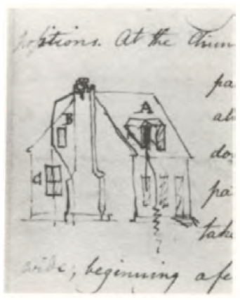
is known from a sketch done in the notebook of B. Henry Latrobe in 1798,
showing the damage done to it by a lightning strike.
![]() |
| The house apparently built for Philip Watson, later the Council Chamber from B. Henry Latrobe, Mayo House, Notebook, 1798 |
The irregularity of Watson’s Tenement as it sloped down from the eastern margin of the Shockoe Hill plateau meant that it was slow to be incorporated into the city’s official grid. Probably as a result, parcels of land at the top of the hill were available for use by public institutions like schools (the Academy of Monsieur Quesney and the Medical College), a theater (the Richmond Theatre and the later Monumental Church), and churches (the Baptist Meeting House). At some point, the city acquired a larger tract of between two and three acres spanning Franklin Street along the west side of the creek for civic purposes, including the eventual construction of the City Jail. Missing city records mean that it is difficult to say in what decade the city acquired the section from the Turpin heirs. Minutes of the Common Hall are missing from May of 1795 until January of 1808 and no mention of the acquisition is recorded in the deed books. The notorious sites associated with the practice of slavery, such as Lumpkin’s Jail and the slave auction houses were located on the part of Watson’s Tenement along the creek to the south of Broad Street.
![]() |
| Jefferson layout for the three Capitol squares, 1780, from Reps. Names of the original lots owners are shown. |
Shockoe Hill was transformed by the arrival of state government. The 1779 act that relocated the capital to Richmond from Williamsburg authorized the Directors of Public Building to find a location for the government buildings in the “open and airy part” of the city. Two locations were proposed by the major landowners in two bluff-top locations: Shockoe Hill and Richmond [Church] Hill. In the following year the General Assembly authorized the appropriation of a site on Shockoe Hill for a new four-part government complex including a “Capitol” for the legislature, a “Halls of Justice” for the courts, a “State House” for the executive boards and committees, and a residence for the governor. Richard Adams, owner of much of the land on Richmond Hill, thought that he had Jefferson’s promise and broke off his friendship when his proposal of twelve lots for the public buildings on Richmond Hill was rejected.
The process of valuing the land to be requisitioned for public use on Shockoe Hill began in 1783. The present site of Capitol Square seems to have been considered from the first, but two tracts that were also considered for taking comprised an area of thirty acres that was part of the former Watson Tenement. This parcel belonged to Horatio Turpin and his brother Dr. Philip Turpin, sons of Thomas Turpin, Thomas Jefferson’s uncle. It was located on Council Chamber Hill, to the east of the County Road [Governor Street]. Owing to the loss of records, including those pertaining to the General Court in Williamsburg, where the Byrds recorded most of their transactions, the history of the property is vague. As we have seen, the Turpins acquired Watson’s Tenement in its entirety after the lease was vacated, well before 1779. It was in that year that Thomas Jefferson, during his term as governor, occupied a house near the corner of Thirteenth and Broad belonging to Thomas Turpin.
Horatio Turpin, deemed the “owner of the lots most valuable for public use,” offered the thirty acres on the Council Chamber Hill for sale to the state and, for free, two 1/2 acres of land that were part of the tract. It included the compact brick building identified as “the house now used by the executive,” known as the “council chamber.” This was offered to the state as the site for the governor’s house [Journal of the House of Delegates 27 June 1783]. This parcel, later the home of John Mayo, would have made an excellent and scenic location for the executive mansion. It was later proposed as the site of a villa for the Mayos by B. Henry Latrobe.
Other lots were valued as well from 1781 to 1784. These
included all the lots that would make up Capitol Square. Most of these were
empty of buildings, but at least two lots on the immediate site of the Capitol
contained buildings. John Gunn had built two houses, occupied by himself and a
tenant, on lots 391 and 404. In addition two lots near the future site of the
Governor’s Mansion, owned independently by cooper John Ligon and
merchant Zachariah Rowland, included valuable buildings. The large frame house
on lot 357, owned by Rowland, was used for the next twenty years, with
increasing levels of dissatisfaction, to house the governor and his
family. This dwelling was close to the
County Road, which it faced, and was sited well below the level of Capitol
Square. Since, according to the 1782 tax
lists, Rowland had arrived in Richmond no earlier than 1780, and was not
registered with this lot in 1782, it seem likely that someone else had it built
at an earlier date (lot numbers are missing for this ward in the tax
list).
The general location was finalized in 1784, when the unitary Capitol building, designed to house all the functions of government, was commenced at the center of the square. The Directors of the Public Buildings decided not to use the thirty-acre site purchased from Turpin, and the legislature returned the land, for which he had not been paid. The state kept the two-acre Council Chamber part of the site and traded it for another portion of the tract just across the County Road from the governor’s house. This lot was already in use as a garden, presumably for vegetables to supply the governor’s table and to provide an attractive setting across from his front door.
In 1787, Turpin was informed that “the public had no occasion for the use of any part” of his land, “except two acres. . . for the purpose of having buildings erected thereon for the residence of the Governor which buildings had they been erected, would have greatly enhanced the value of your petitioner’s property lying adjacent.” Turpin petitioned in 1791 for redress for the loss of value to his property [Richmond City Legislative Petition, 11 Nov. 1791, Library of Virginia]. He continued to sue for relief until well into the nineteenth century, finally receiving compensation for the loss of the two acres in 1809. Meanwhile he had sold the remainder of the Council Chamber tract to Col. John Mayo in 1789.
The Turpin tract was entirely in the hands of Philip Turpin by 1775. He had laid out the flat part at the top of the hill in lots conforming to the adjacent grid pattern by that date, when he sold lots no. 781 and 782 to James Monroe [Richmond City DB 1:43]. The land on Council Chamber Hill and sloping down to the Shockoe Creek he sold in larger unnumbered tracts. As we have seen, these less likely tracts became acceptable sites for public and civic uses. In 1786 he sold a lot to the trustees of the Quesney Academy [Richmond City DB 1:119], which would, after the Richmond Theatre burned, become the site of Monumental Church. At that time he guaranteed that Broad Street (“the Main Street on Shockoe Hill”) should be extended along the entire frontage of the Academy lot. The Baptists acquired a lot east of the Academy.
![]() |
| Map showing location of the Latrobe Theater |
The eastern edge of Shockoe Hill became a prominent location for civic and academic buildings. In the late 1790s it was proposed as the site for a great new Episcopal Church which would have effectively replaced Henrico Parish Church (St. John's) on Church Hill. This church was proposed for an extremely prominent location on axis with (in the center of) Broad Street, appropriate for the position of an established church, a position still held in some contention for the descendent of the Church of England. The church, seen roughly sketched in on a plan of the area drawn by architect B. H. Latrobe, was never built, nor was Latrobe's famous hotel/theater combination seen just above. The history of the eastern slope of Shockoe Hill is continued in part here.
Labels:
Capitol,
Grid,
Jefferson,
Shockoe Hill,
William Byrd
Tuesday, March 24, 2015
City of Monuments, Part I
![]() |
| Photographer Harry Stilson, Soldiers and Sailors
Monument beyond [Style Magazine: from Richmond in Sight]. |
The city’s monuments never stand alone: they join in loosely connected chains of meaning that extend across the city and through time to other cites around the world. We have explored the ways in which civic rituals like parades and processions make use of these armatures in this post.
As Lucien Steil has observed, many memorials record, not only celebrations, but times of disaster or suffering. Commemoration of great struggle and suffering "is not about remembering and reviving acute and relentless destruction, terror, fear, etc., but about overcoming these moments of unbearable pain by moral and material acts of reconstruction. . . . This creative sublimation of the experience of death and destruction, of horror and fear, into symbols of life, continuity and permanence is the paradoxical purpose of commemoration. . . . It is a necessary condition of any cultural endeavor of humanity" [Lucien F. Steil, "Reconstruction and Commemoration." American Arts Quarterly 4:3 (Winter 2015)].
The City’s Memorials
For the purposes of this discussion, these civic markers have been divided into three types: I. Memorials, II. Monuments, and III. Fountains. While each of these may combine some aspects of the others, mingling, for instance, sculpture and flowing water or bas relief and memorial inscription, most of the civic markers in the city can be chiefly identified under one or the other of these categories.
Justin Shubow of the National Civic Art Society has defined two of these civic elements:
In current parlance, “monument” denotes a large (approximately at least 1.5 times the height of an average man) useless permanent immovable structure that honors its subject and was designed to be seen as such. A monument is useless in the sense that it is not meant to have a function other than honoring and commemorating its subject. . . . All monuments are memorials, but not all memorials are monuments. Some memorials contain monuments. Monuments are clear and unequivocal in their meaning; memorials can be abstract and ambivalent. Monuments immortalize their subjects; the subjects of memorials can be permanently dead or finished. Monuments speak; memorials can stay silent. Monuments need no signage; memorials often do.An additional purpose for monuments is emphasized here: that of orienting the viewer within the city, both in the past and present.
The earliest memorials in Richmond were the grave markers in the cemetery surrounding St. John’s Church at the top of Richmond Hill near the northeastern entry to the city at the top of 23rd Street as well as in the city’s successive African American burial grounds (the first Burying Ground for Negroes and the other public and private African American burying grounds that replaced it after 1816) on the sloping sides of Shockoe and Academy hills. It appears that many of the earlier burials at the city's cemeteries were not marked with stones. Stone grave markers would have been the exception in favor of wooden head and footboards. Those early stone markers which do survive at St. John’s not only incorporate carved decoration, but include inscriptions praising the virtues of the dead.
![]() |
| St John's Churchyard in the early 20th century |
Disestablishment of the church coincided with a need for an enlarged burial ground for whites. A first step was the purchase by the city, in 1799, of two adjacent lots on Broad Street to double the size of the burying ground to two acres. The city and church worked out a cooperative agreement for management of the graveyard that holds to this day.
![]() |
| Shockoe Cemetery in 1865 showing overgrown lots and fenced graves with the City Almshouse beyond [Library of Congress] |
![]() |
| Cenotaph tomb of William H. Cabell in Shockoe Cemetery |
![]() |
| Turkey Island Obelisk, Henrico Historical Society |
The unusual obelisk built in 1772 below Richmond on the plantation known as Turkey Island is often cited as an early monument memorializing the “Great Fresh,” a catastrophic flood. It has, however, recently been proposed that the obelisk was not intended for this purpose, but was primarily a component in an important early English Baroque rural landscape design [William Rhodes, "Ryland Randolph and the Palladian Triangle of Colonial Central Virginia." Presentation at the VCU Architectural History Symposium, 2012].
Richmond’s first purposeful civic monument was a constituent but self-contained part of a larger, hybrid work of architecture. Monumental Episcopal Church was planned in 1812 and completed in 1814 to memorialize a deadly theater fire on the same site. Designer Robert Mills grafted a dramatic thirty-two-foot-square monumental Aquia stone porch onto the front of an equally unusual octagonal stuccoed brick church. Mill’s portico is the architectural setting for a monument in the form of a Neoclassical funereal urn symbolically representing the shocking loss felt by Richmond’s citizens. The portico can also be seen as a monument: a symbolically detachable loggia or templum with details and materials contrasting with the body of the church.
The relative independence of the loggia helps to justify the public funding of a sectarian church to memorialize members of the wider population. The exigencies of the situation suggested the hybrid nature of the monument; the city’s Episcopalians desired a new church and were prepared to build in the general area of the theater. The city improvised, not a new building type, but a largely unprecedented composite of models that would permit an effective memorial to those whose remains were indiscriminately mingled in the theater’s foundation. In combining the memorial to so large and diverse a group of victims in one monumental building, the city emphasized, not only a collective sense of loss, but a communal resolution to promote the public good.
Like the raised table tombs that appeared in St. John’s Churchyard in the early nineteenth century, the neoclassical cenotaph at Monumental Church formed a symbolic repository for the bones of the dead, which were actually mingled in the earth beneath the church. Their bones were set aside and marked so that examples would live on in the lives of the city as a whole, whenever a passerby saw the marker or read the text. The monument which consisted of a sarcophagus form topped by an urn, similar to those used in Mycenean times to contain the bones of the dead, is a linear descendent of the tumulus which covered the tomb central to the cults of the Ancient Greek heroes. A form of immortality was achieved when the place of burial was made of permanent materials and the memory of the great deeds of the tomb's occupant was kept alive.
The city’s expanding practice of monument-making also paid deference to the ancient importance of a founding myth, which we have explored here. In much the same way that Richmond was said, improbably, to have seven hills like Rome, in order to lend it a classical air, those responsible knew that by venerating its ancient founders the young city might acquire a sense of permanence. The first monument of the city’s founding may be the copper cross atop a rough pyramid of stones placed on Gamble’s Hill to mark the first visit to the falls by the English settlers. It was dedicated by the Association for the Preservation of Virginia Antiquities in 1907 (and relocated to the Canal Walk in 1983). The monument reenacted the planting of a cross by Captain Christopher Newport three hundred years before, which served to claim the land for the English monarch. The new version was intended to gave legitimacy to the ongoing project of making a city.
The Mayo family, descendants of the city’s original surveyor, had lived for generations at Powhatan’s Seat, on the hill east of Richmond that probably served as the local seat of the Powhatan’s personal tribe. The Mayos carefully preserved at their house a talisman in the form of a stone said to have formed part of Powhatan’s house, sited in the native village at the falls which had been purchased by Captain John Smith and named by him “Nonesuch.” This stone, formerly located along the river, was moved to the crest of Chimborazo Park overlooking the river when it was displaced by the city’s gasworks about 1911. Oddly, William Byrd, the putative father of Richmond, who was an accomplished founder and namer of cities, which he once called “castles in the air,” was never honored with a monument at all, although his name has been applied to a park, a hotel, a theater, and a community center.
One of the city’s earliest outdoor monuments was a small marble obelisk set up in 1834 to memorialize a skirmish between the otherwise victorious British Queen’s Rangers and the Virginia militia. According to the marker on Grove Avenue in the Fan District, probably placed by veterans of the engagement, Virginia forces under Col. J. Nicholas had “driven in” Arnold’s picket on 4 January, 1781. Benedict Arnold had taken Richmond in late 1780 and a regiment under Lt. Col John Simcoe were returning from burning the foundry at Westham west of Richmond. This may have been the “scuffle” for which the nearby hamlet of Scuffletown was named [Drew St.J. Carneal. Richmond’s Fan District. Historic Richmond Foundation, 1996, 14-15].
The two hundredth anniversary of the incorporation of Richmond as a city and of its elevation from a county seat to the state capital was memorialized in 1982. A plaque was appropriately placed at the Old Henrico Courthouse on East Main Street to mark the site where, in the absence of any other city meeting place, there took place the initial election of the twelve members of the city's common hall and of its first mayor, William Foushee.
| Memorial plaque at the Old Henrico County Courthouse recognizing the election there of the city's first governing body. |
Although there were non-sculptural memorials set up before the Civil War, the Confederacy became the subject of the city’s greatest outpouring of memorial-making. The elaborate iron fence surrounding the Hebrew Confederate Cemetery was made in 1866. The posts consist of furled Confederate flags and stacked muskets, with a soldier's cap perched on top. The posts are connected by sabers and swords hung with laurel wreaths. The earliest large-scale monument, built in 1869, rose in Hollywood Cemetery to honor the thousands of dead soldiers buried around it. The ninety-foot granite pyramid reinforced a ritualized theme of loss and death. A large marble obelisk at Oakwood Cemetery in the city’s east end followed soon after funds were raised by 1871.
![]() |
| Confederate Monument, Oakwood Cemetery |
![]() |
| Confederate Monument, Hollywood Cemetery |
The memorialization of history became institutionalized soon after. Plaques recording locations and events were attached to buildings by the Confederate Memorial Literary Society in the first decades of the twentieth century, including the site of Libby Prison in 1911. The series of “Freeman Markers” named for author and editor Douglas Southall Freeman, who promoted them and wrote the texts around 1925, mark the locations of fortifications and battlefields in and around the city for the use of tourists and returning veterans.
![]() |
| Freeman Marker |
| Confederate Memorial Plaque at the Old Henrico Courthouse on East Main Street |
Subscribe to:
Posts (Atom)