“First, What kind of life was lived in this place, that is, Why and how did its builders build as they did?
And second, what rules with general validity and applicability did they follow?”
Carroll William Westfall, Learning From Pompeii.


Sunday, October 18, 2015

PUBLIC ART AND COMMUNITY MEMORY- RICHMOND'S MAGGIE LENA WALKER, PART II

"Urban Scale Richmond takes as its focus the rediscovery of the rules, both explicit and implicit, that have guided the building of the city and give to its art and architecture a unique character. One way to achieve this result (and to reduce the diminution of local conventions and the disempowerment of citizens) is for planners to actively reconstruct the city’s operative patterns. The way in which monuments proceed from a nexus of community expectations is an important part of those patterns. By engaging critically with local issues,  it will be possible to confirm and stimulate healthy growth and change in the city. 

The way in which monuments are procured has an effect on the quality of their 'fit,' although there is no consensus on the best way to control the process. The most complicated part of making a monument is in connecting it in some tangible way, not only with local tradition, but with the expectations of the various constituencies for which it is intended. This is only achieved through careful consideration of location, materials, scale, form, and viewer expectations. Urbanismo hopes for the best!"

This is how we ended our previous post on Public Art and Community Memory: Richmond's Maggie Lena Walker, expressing our concerns the commemorative public art proposed to honor Richmond's Maggie L. Walker . We were apprehensive that the Public Art Commission would guide the designer selection process away from the kind of engagement with the past seemingly favored by the community. A year and a half later, the process described in the post has been completed and we have very good news to report. The city's Public Art Commission announced last week that the commission would be for a statue and that the artist would be prominent American representational sculptor Antonio Tobias Mendez.  Mendez, with a BFA from the Chicago Art Institute, does sports, commemorative, private commissions, and veteran's memorials.

Mayor Dwight Jones announced the decision: “Not only will Richmond gain an important new monument that can reflect the diverse heritage and history of a significant local hero, but this effort will also underscore her role as a champion for civil rights on the national landscape,” said Mayor Jones in a press release. “Maggie Walker was a revolutionary leader in business, a champion for breaking down barriers between communities and showed incredible strength as a person that came out of extraordinarily challenging circumstances to create great things.”

The location of the monument will be in the triangular plot at the intersection of Adams Street and Broad Street, an important node on the urban scale, where the 18th-century road called Brook  Turnpike engages at an angle with the city grid.  This was formerly the site where a fountain was provided to water the horses and oxen drawing wagons and drays as they entered the city (that fountain is now located behind the Bill "Bojangles" Robinson Statue a few blocks to the north. The historic intersection was a key location in Maggie Walker's world and remains a very memorable node in the city's transportation network.  The new statue begins to reinforce an established civic armature. This begins at Franklin and Adams and moves from Maggie Walker's statue at Adams and Broad to the Bojangles statue and beyond.

This commission bodes well for the Maggie L. Walker Monument to join with many others, including the George Washington Monument and the Civil Rights Monument at Capital Square. As we previously observed, that "sculptural ensemble by Stanley Bleifeld avoids the sentimentality that characterizes some of the sculptor's work in other cities and takes a place among the very best monuments of recent decades." Let's hope the Maggie L. Walker Monument will achieve the same levels of formal and emotional strength, and by doing so, help re-establish the legitimacy of figurative public art.   
 
This seriousness should extend to the setting as well as the bronze centerpiece. Mendez's website indicates that "Toby primarily focuses on the figure, combining a classical figurative approach with a contemporary eye for site design." In monument-rich Richmond, the plinth says a great deal about the position of the subject in the city's historical narrative. Offering a sense of "approachability" by placing the statue on the same plane as the viewer has become a hackneyed trope. Maggie Walker, who pointed the way for her community, often from a position on her elevated front porch, would best occupy a raised podium equipped with moldings and set off by appropriate ornament. The setting should support and embrace the statue without seating, planting, or paving elements that draw attention to themselves or work against the city's conventional landscape patterns.

Congratulations to the entire community and the arts commission for making decisions that will contribute to a deeper understanding of Maggie Walker as leader, embodying the civic values she espoused throughout her life.

Thursday, July 16, 2015

Civic Markers II: Monuments as Ordering Elements in the City

"The status of monuments on the cusp of the twenty-first century is double-edged and fraught with an essential tension: outside of those nations with totalitarian pasts, the public and governmental hunger for traditional, self-aggrandizing monuments is matched only by the contemporary artists’ skepticism of the monument" 
James E. Young, “Memory/Monument,” 2010
Lord Botetourt
Civic Markers II: Monuments as Ordering Elements in the City

Political leaders across the nation followed classical precedent in the employment of  rhetorical narratives, sponsoring civic art works to expound on important civic concepts, most often associated with a former military or political leader. Virginia, indeed, began a tradition of public statuary with the marble figure of a much loved royal governor. One of the earliest examples of public statuary in the colonies, the statue of Lord Botetourt, was placed in the central arcade of the Williamsburg Capitol in 1773. 

At first, Richmond, in its role as the new capitol of the commonwealth, built its narrative around political and military figures who were not necessarily local heroes. The state’s leaders memorialized the founding fathers and the larger-than life role Virginians played in the founding of the nation. In 1796, Houdon’s virtuoso life-size sculpture of George Washington took a central place in the new Capitol, a position that was equivalent to that previously occupied by Lord Botetourt’s statue in Williamsburg. Both Botetourt and Washington were here treated as modern citizens in modern dress, although Washington was accompanied by the symbols of the Roman hero Cincinnatus, who, like Washington, turned from war-craft to farming. 


As Charles Brownell and his student Ramin Saadat asked, why, at the Virginia Capitol, had Jefferson "devised a templelike exterior and a templelike core surrounding a white marble statue in a fashion suggesting divine honors?” The answer, they suggest, may lie in the popular theory, known as Euhemerism, that saw the origin of ancient gods in mortal “leaders or benefactors” whose veneration had “naively evolved into worship.” 

It became necessary to call upon at least a modicum of myth in order to craft  an aestheticized history that met the new nation’s ideological needs. . . .  “American” versions of the methods by which Italy’s Renaissance packed the past with rich meanings eventually found their way into the national imagination, especially after the rising commitment to manifest destiny began to overlay republican modesty with grandiose images of heroic glory. But in the beginning the Capitol dealt with America’s first president in its own way. By a reversal of the euhemeristic tradition, as we will see in the making of the myth of George Washington, the mortal man became a demigod. 

George Washington as America’s savior general and first president would endow the nation’s capital with what Renaissance Italy named civile- “the affective identification of the [citizen] with a particular, geographically defined place,” as well as “a belief in the sacred nature of institutions and leaders, an attitude that invests things and persons political with a mystical aura, distinguishing them from mundane structures and from ordinary mortals.”

Public ceremonies required the right person to represent the nature of the republican virtues Americans were making up as they went along. . . . In both the Old World and the new, ceremonies of adventus sealed the relation of leaders to the people (private individuals, the military, the administrative staffs). They confirmed the needed sense of stability and order, backed by a coherent bureaucratic system. Over time, however, it became unnecessary to highlight the “action” by which a leader “arrives.” He is “just there” through a process that has been “completed and consummated.” . . . John Quincy Adams was deeply depressed by the implications of the inability to reach a compromise over the final resting place of the nation’s foremost symbol of unity. In his diary of February 22, 1832, Adams wrote that the wish for the capitol to be the site of Washington’s tomb had been “connected with an imagination that this federal Union was to last for ages. I now disbelieve its duration for twenty years, and doubt its continuance for five. It is falling into the sear and yellow leaf” [Martha Banta, One True Theory and the Quest for an American Aesthetic (Yale U Press, 2007, 77ff].

The indoor statue of Washington, “its form the result of a transatlantic dialog between Houdon, Thomas Jefferson, then serving as minister plenipotentiary to the court of Louis XVI, political figures in Virginia, and Washington himself,” depicted him as a modern Cincinnatus, the Roman general who voluntarily returned to farming after his success at war.  Maurie D. McInnis sees this as entirely appropriate republican imagery for the post-revolutionary period. Changes in the nation’s self-understanding gave impetus to an entirely different project for memorializing Washington in the 1850s, one that “captures the changing meaning of Washington and the Revolution for different generations of Virginians.  “By the middle of the nineteenth century, however, Washington as Marcus Aurelius, the great military leader, seemed more appropriate to Virginia’s leading men. . . . The second, by Crawford, was a response to the first, commissioned by a later generation of Virginians, who, in the 1850s, were attracted not to the symbols of pastoral virtue, but instead to the military might of Washington, as sectional tensions dictated a celebration of Washington’s military prowess as a defender of Southern liberties [Maurie McInnis, “George Washington, Cincinnatus or Marcus Aurelius?” from Peter S. Onuf and Nicholas P. Cole eds, Thomas Jefferson, the Classical World, and Early America. University of Virginia P, 2011].   

Thomas Crawford's equestrian Washington, 1858
Thus the Richmond tradition of outdoor public military monuments began with a sculptural composition to immortalizing in bronze and granite Virginia’s role in the nation’s founding and Virginia’s most famous citizen, George Washington. Maximilian Godefroy, who prepared landscape plans for Capitol Square, had proposed a triumphal arch in front of the capitol’s portico as well as a viewing platform/water tower to its west. The General Assembly authorized a public subscription for a monument and burial place on the Capitol Square for Washington in 1817. After years of inaction, a committee of citizens proposed a competition for the monument, which was held in 1849. The selected sculptor was Thomas Crawford, an American working in Rome. The popular and successful monument was not only a tribute to Washington as military and political leader, but an elaborate allegory linking Virginia with the national polity.


The monumental composition stands on a granite base appropriately shaped like a hexagonal star fortress. The design includes two tiers of supporting sculptures around a massive bronze equestrian figure of Washington, cast in Germany. The upper row of pedestals support statues of six Virginia patriots- Thomas Jefferson, George Mason, John Marshall, Andrew Lewis, Thomas Nelson, and Patrick Henry. The lowest tier consisted of six allegorical female figures and trophies representing revolutionary virtues (and places) allied with the six patriots. Andrew Lewis is allied with “colonial times,” Patrick Henry with revolution, George Mason with the Bill of Rights, Thomas Jefferson with independence, Thomas Nelson with finance, and John Marshall with justice. Crawford died having completed only the sculptures of Washington, Jefferson, and Henry.  His student, Randolph Rogers, completed the remaining pedestal sculptures after the Civil War.  The monument strongly reinforces the urban order by serving as a objective at the end of Grace Street at the entrance to Capitol Square. It stands on axis with the Governor’s Mansion and in an effective non-axial introductory relationship with the Capitol itself. The nearby Washington Tavern was renamed the Monumental Tavern in its honor [Hopson Goddin, Richmond Virginia 1861- 1865, Civil War Centennial Committee, 1961].


Henry Clay Statue under the octagonal canopy, 1860

The Washington monument did not stand alone in Capitol Square for long. It was followed by the life-sized Henry Clay statue in 1860, located north of the Capitol. Henry Clay, born in Hanover County, Virginia, was a renowned statesman, orator, and long-serving speaker of the the U.S. House of Representatives who had studied law in Richmond with George Wythe. Clay was a hero to the Whig population of the city, who favored federalist policies promoting economic, social, and moral modernization in opposition to the populism of Andrew Jackson. The artist was the Kentucky-born sculptor Joel T. Hart (1810-1875). The statue was commissioned in 1845 by the Ladies Clay Association, in order to rescue his cause “from the foulest slanders ever invented for party purposes” during the presidential election of 1844 and to “teach our Sons to honor [his] name- and imitate [his] noble deeds” [The Papers of Henry Clay, January 1, 1844-June 29,1852, 1991: U P of Kentucky:203]. 

It took Hart until 1859 to arrange production of the marble sculpture in Italy.  The statue was placed under an octagonal, domed covering soon after its dedication in 1860. The cast-iron canopy, supported on eight Corinthian columns, was itself a major public amenity in Capitol Square and emphasized the heroic status of Clay in the eyes of the city. Unfortunately, the fifteen-year delay in the production of the monument meant that its intended influence in favor or compromise and federalism was of no use at the start of the Civil War. Unlike George Washington, the significance of Henry Clay was largely forgotten by the early twentieth century. The domed temple was demolished in the 1930s and the statue placed inside the Capitol.  


A life-sized statue of Thomas J. “Stonewall” Jackson was placed nearby in 1875, beginning a line of monuments that would be erected in the twentieth century along the northern edge of the square. The bronze sculpture was made in 1875 by Irish sculptor John Henry Foley and was the gift of “English gentlemen as a tribute of admiration.” 

It was a result of its former role of “national capitol” that Richmond acquired an extensive and more urbane collection of public art surpassing that of other state capitals of comparable size. The armature of monuments extending from the old city into the projected suburbs to the west was the serendipitous result, not of public planning, but of a family who wished to extend the city through their property.

Monument Avenue

Richmond's great urban processional route, Monument Avenue, represents the transformation of loss and suffering into a symbolic reconstruction of the partially burned city as a monument to its aspirations. As Lucien Steil has said: "The city is indeed the highest form of commemoration, the highest expression of resilience, the most beautiful synthesis of human culture." Lucien Steil, "Reconstruction and Commemoration." American Arts Quarterly, 4:3 (Winter 2015). 

Monument Avenue was laid out in 1887, not only to serve as an appropriate setting for the heroic statue of Robert E. Lee planned to stand at the center of a great circle at its eastern end, but as a grand extension of the city to the west.

As was documented by Jay Killian Bowman Williams, Monument Avenue was largely the creation of its property owners, beginning with the Allen family, who owned the site of Lee Circle. The city and most of the promoters of the statue wanted it to be placed in a familiar and existing location such as Capitol Square, Libby Hill, or Monroe Park. The Board of the Lee Memorial Association, having been convinced by, among others, Augustus St. Gaudens, that an accomplished European sculptor would produce the best work, hired Frenchman Jean Antoine Mercier and mandated a calm, serene Lee who would project a sense of the moral and aesthetic seriousness of the southern cause missing in the booming New South city that doubled in size between 1860 and 1890 [Jay Killian Bowman Williams, Changed Views and Unforeseen Prosperity: Richmond of 1890 Gets a 
Monument to Lee (Richmond: privately printed, 1969)]. 

Col. Otway Allen promoted his vision for his tract of undeveloped land at the western end of Franklin Street as the best place for the monument. Franklin Street was the pre-eminent residential axis, extending from Capitol Square’s Bell Tower to the city’s western limits. Allen insisted that “no better situation (as far as a site for the Lee Monument) could be obtained than at the head of Franklin Street. There is a prospect of the street being opened, and a place similar to Monument Place in Baltimore being laid out. Should this be done, where is a situation to compare with it?” 

A famous image of the Lee Monument, with a crop of tobacco growing in front of it. This has always looked to us like a  a publicity stunt.
Writers, including Henry James, who have mocked the messy selection process and the lonely situation of the Lee Monument in an undeveloped landscape, have failed to grasp the developers’ foresight and the similarity of this project other grand urban expansions.  Early Monument Avenue compares favorably with the dreary expanses of nineteenth-century District of Columbia. In previous decades, Baltimore’s Washington Monument (1815-1829) preceded development of its projected setting in Mount Vernon Square by many years. 

By the late nineteenth century, Richmond’s civic leaders lacked the political capacity to imagine or provide such a generously scaled setting for the monument on their own. This kind of effort required an unprecedented manipulation of the city’s grid, as ambitious, in its own way, as the creation of the great boulevards that were driven through the heart of Paris by Hausmann. Collison Pierpont Edwards Burgwyn, a civil engineer, novelist, and playwright employed by the Allens, laid out the 200-foot diameter Lee Circle and the two 140-foot wide boulevards converging on it. Monument Avenue closely resembles Frederick Law Olmstead’s contemporary project at Commonwealth Avenue in Boston. In a similar way, Commonweath Avenue was laid out on private land as the idea of developer and street railway operator, Henry M. Whitney.  

Monument Avenue looking west from Stuart Circle
Monument Avenue gradually extended to the west and its intersections became the settings for a sequence of public sculpture on a scale rarely achieved in an American city. Monumentally scaled statues of Confederate figures, some more effective than others, and none as fine as Lee’s, were eventually placed at the center of every other intersection for more than a mile. 

Older parts of the city had made no distinction among streets or sections by building type or land use, and streets were able to incorporate changes in form and use over time. This new boulevard was intended serve a distinctly residential suburban sector and was not intended to be a principal thoroughfare. Eventually, however, with the coming of the automobile it became a convenient commuters’ route into the city.  Oddly, and due to its emphatically axial form, Monument Avenue doesn’t accommodate public buildings quite as well as the older, reticulated parts of the city. Except at Stuart Circle, where two churches, a hospital, and an apartment building manage to enclose the more intimate circle there, churches and the few other larger buildings fail to fully engage with the street’s massive scale. One success in this regard is the temple-form church at the south end of Allen Street, which effectively terminates that street.     

Other Post-Civil War Civic Markers

While the Allens were developing Monument Avenue, another individual was responsible for creatively managing urban-scale improvements across a post-war city with little interest in spending money on public works. Col. Wilfred Emory Cutshaw, a VMI-trained engineer, began a long career as city engineer in 1873.  According to Tyler Potterfield, Cutshaw, who was responsible for the planning and supervision of municipal projects, “fully recognized the importance of neighborhood squares, tirelessly advocated for their improvement and oversaw a team of assistant city engineers who proved to be talented landscape designers.” Preparation for his position included travel to study up-to-date parks in the North and in Europe in 1879. 

Soldiers and Sailors Monument by William Ludwell Sheppard, 1894
 Cutshaw landscaped Monroe Park and the large “promontory parks” overlooking the James. He also acquired the small triangular parks that enliven Park Avenue in the Fan District and organized a sophisticated tree-planting program that provided shade throughout the city’s streets and parks in accord with the City Beautiful movement, an urban design branch of the American Renaissance.  His plan to create a dramatic monument to Robert E. Lee on the top of Libby Hill Park was rejected, but in its place he projected the Soldiers and Sailors Monument of 1894, which took the form of a Roman monumental column, placed on a highly visible axis carefully aligned with Main Street to the west [T. Tyler Potterfield, Nonesuch Place: A History of the Richmond Landscape (History Press, 2009)].


A triumphal arch constructed as a temporary 
entry gateway to the popular Street
Carnival held on Broad Street
in 1900. 
Arches have long been a theme in monumental Richmond. Street-spanning arches were proposed, but not built, for both George Washington and Jefferson Davis. Their lack of success is particularly instructive in the inherent contentiousness of myth- and monument-making in a democratic regime. A temporary triumphal arch "beautifully festooned with flowers and evergreens," was built over Main Street at 19th Street beside the Union Hotel for Lafayette's parade in 1824. Thirteen girls "stood upon the arch to represent the thirteen original states" [Dan Murphy's Reminiscences, Part II]. The success of temporary arches built over Broad Street in 1900 and 1901 for street carnivals that were designed to “boost” the city seems to have prompted the United Daughters of the Confederacy to propose a monumental arch in 1902 over Broad Street at the intersection of Twelfth Street as a memorial to Jefferson Davis (the dramatic location where Broad Street drops off into the Shockoe Valley attracted propsals for structures at the urban scale over the years, starting with the Shockoe Market and Latrobe’s unexecuted project for a new Episcopal church, both proposed for the center of the street).


"Triumphal" arch in stone proposed for Monroe Park soon after Jefferson Davis' death in 1889.
An arch was again suggested to span Broad Street in 1901 [City on the James, 1893].

The grandious project broke down due to the sensible objections of Davis' widow, who indicated that she was opposed the location and the form of the proposed monument, not to mention its being harnessed to the promotion of the city. She declared that "arches, as monuments, have been built to perpetuate deeds of men and to express the idea of a ‘victory achieved.’ A triumphal arch to the memory of a man whose cause failed. . . is surely an inappropriate way to express respect for his memory, and certainly might excite ridicule in many quarters. Bound by a thousand most tender ties and a warm sympathy to Richmond, yet even to beautify the city I cannot approve the site at Broad and Twelfth Streets. . . . [at] the intersection of two of the noisiest and busiest streets, lined with shops and frequented by crowds of people of a prosperous and growing city" [Richmond Dispatch 1 June 1902]. 

First Regiment of Virginia Monument at Park Stuart and Meadow streets by Ferruccio Legnaioli
Additional Statues

A tradition began of placing statues at key points around the city, begun by Cutshaw, continued to punctuate the axes of transportation routes and along paths in public parks. These include the statue of A.P. Hill at Laburnum and Hermitage and the figure of Williams Carter Wickham (1820 –1888), a lawyer, judge, politician, and Confederate Cavalry commander, who image was placed in Monroe Park by his war-time comrades and employees at the Chesapeake and Ohio Railway in 1891. It was sculpted by Richmond’s Edward V. Valentine. The Richmond Howizers Monument (1892) and the Monument to the First Regiment of Virginia Infantry (1930) punctuate the irregular route of Park Avenue as it wends its way through the Fan District. 


Columbus statue and fountain

As the Fan District was extended to the west, Boulevard was laid out in 1875 as a grand cross street to connect Reservoir (Byrd) Park to Broad Street. The terminus at the foot of the great reservoir was given an suitably architectural effect by the placement of a small cascade fountain symbolizing the civic provision of water fronted by a statue of Columbus. This was placed in front of the fountain in 1925 by a group of citizens of Italian origin and sculpted by immigrant sculptor Ferruccio Legnaioli.


The discourse on Richmond's Civic Markers will continue with Part III- Fountains.

For a discussion of contemporary monumental art, see Public Art and Community Memory: Richmond's Maggie Lena Walker.

Friday, June 26, 2015

The School of Life: How to Make an Attractive City


Here is a great short film that summarizes some of the most salient points about making beautiful cities.

Sunday, June 14, 2015

Critiquing "Sterilizing Development" in Historic Areas


Typical "patchwork" apartments in Richmond's historic center.
Urban advocates in Charlotte NC are taking a close look at the massive new multi-family apartment complexes that are transforming historic neighborhoods in a way that is becoming increasingly familiar here in Richmond. Is there a way to do new housing in city centers without damaging the fragile historic fabric of the small commercial and residential background buildings that provide the setting for the rich civic life, great cuisine, and commercial diversity that characterize Richmond's "bottom-up" revitalization in recent years? Is there a way to make new buildings that are more timeless in appearance and durable in materials, and that also respect the city's historic patterns of building?


Old Stone Row in Richmond's Shockoe Valley.


New apartment building in historic Jackson Ward.


Image:  Opponents of a new apartment complex at a recent Charlotte City  Council meeting credit: Ely Portillo, Charlotte Observer
In Charlotte a group of committed urbanists have organized "Civic by Design," a forum partnered with a wide array of cultural and design-related institutions, that intends "to elevate the quality of our region’s built environment and to promote public participation in the creation of a more beautiful and functional region for all." New Urbanist architect Tom Low, based in Charlotte, recently posted news of the forum on the traditional TradArch List.

The group has effectively defined the dense, cheap apartment blocks appearing in American cities as "sterilizing development." More than 10,400 units are under construction in Charlotte, with more than 10,300 planned. As in Richmond, many are four- or five-story mid-rise buildings being constructed in historic neighborhoods. These buildings are out of character with their surroundings in scale, materials, and proportion. Their designers attempt to mitigate their massiveness by applying a variety of exterior finishes in a seemingly patternless collage, often mixing brick, cement board, and corrugated metal. One prominent Richmond traditional architect has named this kind of form "RPQ, the Random Patchwork Quilt Style."

In Richmond, unlike in Charlotte, there has been little criticism of these new apartment blocks, perhaps because they are not yet as widespread and have not yet caused an extensive demolition of much-loved older buldings. The principal conversation in the past has been over the official design standards for new buildings in historic districts and the lack of external windows in a surprising number of rehabilitated lofts funded by historic preservation tax credits. 

Read more here: http://www.charlotteobserver.com/news/business/biz-columns-blogs/development/article23919511.html#storylink=cpy

A forum at Charlotte's Levine Museum of the New South on June 9th defined the problem:


"Sterilizing development can be defined as new development that is too dense, too tall, too quick and diluting the funky character that makes our historic neighborhoods special.   These new designs are completely different in character and feel, quality, and style of bland, boring, beige, behemoth boxes all with the same look, the same standards, same floor plans.  This coarse grain approach is wiping out affordable housing and hole-in-the-wall neighborhood hang-outs, forcing people out and changing both the character and the social structure.  Developments with weak design and poor construction will not age well and quickly become passé, leaving neighborhoods to deal with the negative consequences in their wake.  Please join Civic By Design as we explore how development is sterilizing Charlotte."
The forum explored ways to change or mitigate the direction of development in Charlotte:
 
 
"1.  Review current design and redevelopment projects and their pros and cons for improving and harming neighborhoods and citizens — inclusive vs. elite, fine-grain vs. too coarse, durable vs. disposable?
2.  Determine what is key — can better civic design preserve elements of what is here now and allow for something new to come in and is it possible to control this? 
3.  Analyze the time and financial challenges developers along with the constraints and design teams must address and what options should be considered — the benefits and backlash of strong and time-consuming strict historic standards if imposed or are there other options?
4.  Explore ideas for a better and more civic design and development process as well as tools and techniques and how they can help —   where economics do not trump sentiment."

Civic by Design has come up with this alternate design for the kinds of bland, big-box developments that are overwhelming Charlotte's small-scale historic districts. This for an area around "Tommy's Pub," a much-loved landmark threatened with demolition.


Thanks to Tom Low on TradArch List.


Tuesday, May 5, 2015

Westward Ho: Watson's Tenement, Turpin's Addition, and the Development of Shockoe Hill


Watson Ho., Detail of Madison Map of 1818


As we have seen elsewhere, the plateau on top of Shockoe Hill was laid out in streets in 1768 and the approximately 90 full squares, each containing four 1/2-acre lots, and 16 half squares. This new town called Shockoe, part of the lands of William Byrd III, was incorporated into the city in the following year. The development on Shockoe Hill was slow to develop, but the area at the top of the hill attracted some merchants and overnight lodging at the top of the old “County Road” that entered Richmond from the east at Gillies Creek and connected the town to points east and west.  Maps show that the narrow, curving way that traversed Henrico from east to west (probably begun as an Indian path) climbed the bluff from Shockoe Creek to the top of the hill. It continued to the west in a path that roughly approximated H or Broad Street, but did not strictly obey the official guidelines of the grid.


Watson’s Tenement on the inset map of Byrd’s Lottery on Richard Young’s 1809 Map of
 Richmond. This map originated in 1768 and includes the platted town of Shockoe west
 of the creek labeled “Town Land.”


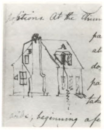
The tract of undeveloped land to the north and east of the County Road was known as Watson’s Tenement. It had been leased by Philip Watson, merchant, from William Byrd III- the lease appears to have been renewed in 1757. It then comprised 128 acres and included, according to the lease of 1757, a brick dwelling “where the said Philip now dwelleth,” a brick store, and a frame granary. It seems likely that the brick house was the same as the one 1/2-story dwelling that later served as the Council House and the town residence of Col. John Mayo.  The appearance of that house is known from a sketch done in the notebook of B. Henry Latrobe in 1798, showing the damage done to it by a lightning strike. 

Detail of James Madison, A Map of Virginia 1807. The Philip Watson/Council Chamber
 House is seen to the right of the center fold, standing nearly alone at the top of the
 steep slopes of Council Chamber Hill.


The house apparently built for Philip
Watson, later the Council Chamber
from B. Henry Latrobe, Mayo
House, Notebook, 1798

Thomas Turpin purchased Watson’s Tenement from William Byrd III [probably recorded in the General Court and now lost] as noted in a deed of 1783, when Turpin sold 93 1/2 acres, the remainder of the tenement after the sale of lots on the hill, to his son, Dr. Philip Turpin. The western section of the tract that was occupied by Watson was left blank on the plat of Shockoe that was made in 1768, north of Broad between Eighth and Twelfth streets. This section, later known as Turpin’s Addition and Court End, was laid out in lots and incorporated into the city by Thomas Turpin in 1780. The undeveloped remainder of Watson’s Tenement ran east down to Shockoe Creek. The southern portion of this sloping land, containing Watson’s brick residence, had been considerably improved and was valued by a jury at 4,000 lbs specie. The other half, to the north, where the Quesnay Academy,  Richmond Theatre, Baptist Meeting House, Medical College, City Jail, and Lancastrian School were to stand, was considered less valuable, assessed at only 1,000 lbs. 


Detail, Mijacah Bates 1835 Map of Richmond showing the area of the Burial Ground. The
 three lots extending west from 15th Street were the site of the residence of James
 Goodwin in 1807. The irregular lot on which the City Jail (1830) and the Lancastrian
 School (1816) are shown was public land on which a burial ground, gallows, and
 magazine could be placed.


The irregularity of Watson’s Tenement as it sloped down from the eastern margin of the Shockoe Hill plateau meant that it was slow to be incorporated into the city’s official grid. Probably as a result, parcels of land at the top of the hill were available for use by public institutions like schools (the Academy of Monsieur Quesney and the Medical College), a theater (the Richmond Theatre and the later Monumental Church), and churches (the Baptist Meeting House).  At some point, the city acquired a larger tract of between two and three acres spanning Franklin Street along the west side of the creek for civic purposes, including the eventual construction of the City Jail. Missing city records mean that it is difficult to say in what decade the city acquired the section from the Turpin heirs. Minutes of the Common Hall are missing from May of 1795 until January of 1808 and no mention of the acquisition is recorded in the deed books. The notorious sites associated with the practice of slavery, such as Lumpkin’s Jail and the slave auction houses were located on the part of Watson’s Tenement along the creek to the south of Broad Street. 


Jefferson layout for the three Capitol squares, 1780, from Reps. Names of the original
 lots owners are shown.

Shockoe Hill was transformed by the arrival of state government. The 1779 act that relocated the capital to Richmond from Williamsburg authorized the Directors of Public Building to find a location for the government buildings in the “open and airy part” of the city. Two locations were proposed by the major landowners in two bluff-top locations: Shockoe Hill and Richmond [Church] Hill. In the following year the General Assembly authorized the appropriation of a site on Shockoe Hill for a new four-part government complex including a “Capitol” for the legislature, a “Halls of Justice” for the courts, a “State House” for the executive boards and committees, and a residence for the governor. Richard Adams, owner of much of the land on Richmond Hill, thought that he had Jefferson’s promise and broke off his friendship when his proposal of twelve lots for the public buildings on Richmond Hill was rejected.


The process of valuing the land to be requisitioned for public use on Shockoe Hill began in 1783. The present site of Capitol Square seems to have been considered from the first, but two tracts that were also considered for taking comprised an area of thirty acres that was part of the former Watson Tenement. This parcel belonged to Horatio Turpin and his brother Dr. Philip Turpin, sons of Thomas Turpin, Thomas Jefferson’s uncle. It was located on Council Chamber Hill, to the east of the County Road [Governor Street]. Owing to the loss of records, including those pertaining to the General Court in Williamsburg, where the Byrds recorded most of their transactions, the history of the property is vague. As we have seen, the Turpins acquired Watson’s Tenement in its entirety after the lease was vacated, well before 1779. It was in that year that Thomas Jefferson, during his term as governor, occupied a house near the corner of Thirteenth and Broad belonging to Thomas Turpin.   

1768 plat of the Town of Shockoe as found among Jefferson's papers with
 undifferentiated grid pattern. The pre-existing tenements (including the very large 
extent of Watson's Tenement) and lots along Shockoe Creek are shown at the right.  

Horatio Turpin, deemed the “owner of the lots most valuable for public use,” offered the thirty acres on the Council Chamber Hill for sale to the state and, for free, two 1/2 acres of land that were part of the tract.  It included the compact brick building identified as “the house now used by the executive,” known as the “council chamber.” This was offered to the state as the site for the governor’s house [Journal of the House of Delegates 27 June 1783].  This parcel, later the home of  John Mayo, would have made an excellent and scenic location for the executive mansion. It was later proposed as the site of a villa for the Mayos by B. Henry Latrobe.


Other lots were valued as well from 1781 to 1784. These included all the lots that would make up Capitol Square. Most of these were empty of buildings, but at least two lots on the immediate site of the Capitol contained buildings. John Gunn had built two houses, occupied by himself and a tenant, on lots 391 and 404. In addition two lots near the future site of the Governor’s Mansion, owned independently by cooper John Ligon and merchant Zachariah Rowland, included valuable buildings. The large frame house on lot 357, owned by Rowland, was used for the next twenty years, with increasing levels of dissatisfaction, to house the governor and his family.  This dwelling was close to the County Road, which it faced, and was sited well below the level of Capitol Square.  Since, according to the 1782 tax lists, Rowland had arrived in Richmond no earlier than 1780, and was not registered with this lot in 1782, it seem likely that someone else had it built at an earlier date (lot numbers are missing for this ward in the tax list).  

The general location was finalized in 1784, when the unitary Capitol building, designed to house all the functions of government, was commenced at the center of the square. The Directors of the Public Buildings decided not to use the thirty-acre site purchased from Turpin, and the legislature returned the land, for which he had not been paid. The state kept the two-acre Council Chamber part of the site and traded it for another portion of the tract just across the County Road from the governor’s house. This lot was already in use as a garden, presumably for vegetables to supply the governor’s table and to provide an attractive setting across from his front door.


Philip Turpin's Lots , 1787, Library of Virginia. Main Street is today's Broad Street and the
 street at the right edge is 13th Street. Lot No. 749 appears to be the lot that Gov.
 Thomas Jefferson rented from Thomas Turpin in 1779.

In 1787, Turpin was informed that “the public had no occasion for the use of any part” of his land, “except two acres. . . for the purpose of having buildings erected thereon for the residence of the Governor which buildings had they been erected, would have greatly enhanced the value of your petitioner’s property lying adjacent.” Turpin petitioned in 1791 for redress for the loss of value to his property [Richmond City Legislative Petition, 11 Nov. 1791, Library of Virginia]. He continued to sue for relief until well into the nineteenth century, finally receiving compensation for the loss of the two acres in 1809. Meanwhile he had sold the remainder of the Council Chamber tract to Col. John Mayo in 1789.

The Turpin tract was entirely in the hands of Philip Turpin by 1775. He had laid out the flat part at the top of the hill in lots conforming to the adjacent grid pattern by that date, when he sold lots no. 781 and 782 to James Monroe [Richmond City DB 1:43].  The land on Council Chamber Hill and sloping down to the Shockoe Creek he sold in larger unnumbered tracts.  As we have seen, these less likely tracts became acceptable sites for public and civic uses. In 1786 he sold a lot to the trustees of the Quesney Academy [Richmond City DB 1:119], which would, after the Richmond Theatre burned, become the site of Monumental Church. At that time he guaranteed that Broad Street (“the Main Street on Shockoe Hill”) should be extended along the entire frontage of the Academy lot. The Baptists acquired a lot east of the Academy. 


Map showing location of the Latrobe Theater

The eastern edge of Shockoe Hill became a prominent location for civic and academic buildings. In the late 1790s it was proposed as the site for a great new Episcopal Church which would have effectively replaced Henrico Parish Church (St. John's) on Church Hill. This church was proposed for an extremely prominent location on axis with (in the center of) Broad Street, appropriate for the position of an established church, a position still held in some contention for the descendent of the Church of England. The church, seen roughly sketched in on a plan of the area drawn by architect B. H. Latrobe, was never built, nor was Latrobe's famous hotel/theater combination seen just above. The history of the eastern slope of Shockoe Hill is continued in part here.