
Thursday, March 24, 2016
Paths to Tradtional Architecture
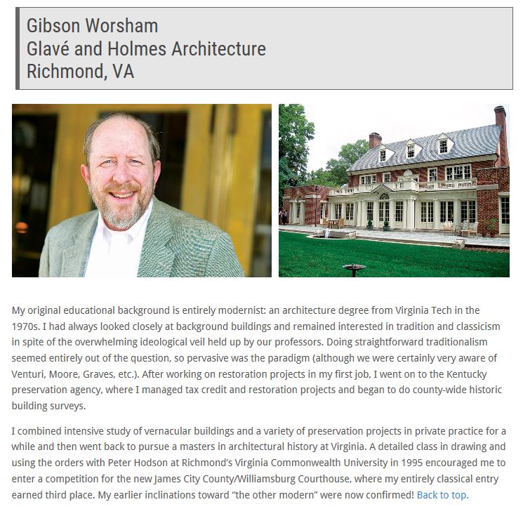
We were pleased to find ourselves in company with some of our favorite architects, urbanists, and craftsmen this month, with the publication the month of an excellent set of profiles in Traditional Building Magazine. The article, compiled by architect Paul A. Ranogajec, details in brief the professional trajectories of a number of classical practitioners across the country. Here is the entry we submitted- we encourage you to read the others to see the variety of ways designers have rediscovered and revived aspects of the traditional and classical city.


Thursday, December 3, 2015
The Location of Richmond’s first African-American Burial Ground.
 |
| Detail, Adams Map of Richmond, 1858, showing the area formerly the site of the African Burial Ground |
The question of the location and boundaries of the Richmond's historic first African-American Burial Ground has generated a series of conflicting reports, amplified by the undoubted sensitivity of the topic and the unpopular attempt to build a new ballpark in its immediate vicinity. Attempts at resolving the question have assisted in focusing attention on the small tract of land that condensed the realities of degradation and death for Richmond's enslaved and free black population in the first half of the nineteenth century.
This study purports to show that the first Burial Ground for
Negroes very likely shared a portion of its boundaries with a busy tract of
publically owned land on the edge of the Shockoe Valley settlement. Careful consideration of the ownership of land in the area of the burial
ground can help to solve the thorny question of exactly where it was located. The
parcel of city-owned land appears on later maps and deeds but is poorly
documented in the public record.
 |
|
Watson’s Tenement on the inset
map of Byrd’s
Lottery on Richard Young’s 1809 Map of Richmond. This map originated in 1768
and includes the platted town of Shockoe west of the creek labeled “Town Land.”
|
Background- Watson’s Tenement
In 1780, when Richmond became a city, the majority of residents lived east of Shockoe Creek on the grid established by William Byrd in the 1730s. The plateau to the west on Shockoe Hill was laid out in streets in 1768 on the lands of William Byrd III and was incorporated into the city as the Town of Shockoe in the following year. The tract on Shockoe Hill was slow to develop, but one area, just at the top of the hill, attracted merchants and tavern operators along the old “County Road” that climbed the steep hillside and connected the town to points east and west.
A large tract of undeveloped land on Shockoe Hill to the north and east of the County Road pre-dated the lots of 1768. It was known as Watson’s Tenement because it had been leased by Philip Watson, a merchant, from William Byrd III. It is not clear when Watson acquired the lease, but it appears to have been renewed in 1757, at which time it comprised 128 acres. At some date after that, Thomas Turpin purchased Watson’s Tenement from William Byrd III, as noted in a deed of 1783, when Turpin sold 93 1/2 acres, the remainder of the tenement after the sale of lots on the hill, to his son, Dr. Philip Turpin. This undeveloped remainder of Watson’s Tenement ran east from the Shockoe Hill lots down to Shockoe Creek. The southern portion of this sloping land, containing Philip Watson’s brick residence, had been considerably improved and was valued by a jury at 4,000 lbs specie. The sloping land of the portion to the north was considered less valuable and was assessed at only 1,000 lbs.
Owing to the loss of records, including those pertaining to the General Court in Williamsburg, where the Byrds recorded most of their transactions, the history of the property is vague. Thomas Turpin acquired Watson’s Tenement in its entirety after the lease was vacated, well before 1779. It was in that year that Thomas Jefferson, during his term as governor, occupied a house near the corner of Thirteenth and Broad belonging to Turpin.
The Turpin tract was entirely in the hands of Philip Turpin by 1775. He laid out the flat part at the top of the hill in lots that extended the adjacent Shockoe Hill grid pattern by 1775, when he sold lots no. 781 and 782 to James Monroe [Richmond City DB 1:43]. The land on Council Chamber Hill and sloping down to the Shockoe Creek he sold in larger unnumbered tracts. These less likely tracts became acceptable sites for public and civic uses. In 1786 he sold a lot to the trustees of the Quesney Academy [Richmond City DB 1:119]. This became the site of the Richmond Theatre, which after its destruction in a horrific fire, was replaced by Monumental Church. At that time, Turpin guaranteed that Broad Street (“the Main Street on Shockoe Hill”) should be extended along the entire frontage of the “Academy lot.” The city’s Baptists acquired a lot east of the Academy.
At the bottom of the hill, in a bend of Shockoe Creek, the city invested in an irregularly shaped tract. While the date of purchase is not known, this property was to serve numerous secondary purposes over the following century and plays a key role in the search for the Burial Ground. The corporation’s tract of land is first seen on the Bates Map of 1835 containing the City’s jail and principal public school. Angled property lines separating the city’s parcel and the other tracts along the west side of the creek from the lots on higher ground to the west probably correspond to the shapes of the bluff dividing them. On this map, the formerly inaccessible tract has been divided and joined to the rest of the city by extension of the streets to the north, east, and south, while the formerly winding Shockoe Creek has been channeled into a new bed to the east.
 |
|
Detail, Mijacah Bates 1835
Map of Richmond showing the area of the city property on the west side of
Shockoe Creek. The Rutherfoord lots extending west from 15th Street were the
site of the residence of James Goodwin before 1807. The irregular lot on which the
Lancastrian School (1816) and the City Jail (1830) are shown is the pubic land.
It seems likely that this is the very same tract on which the burial ground,
gallows, and magazine were placed.
|
 |
|
Young’s 1809 Map of Richmond
showing the site of the Burial Ground on the northeast side of what would become
Broad Street, with the gallows in the center (marked with the letter N) and the
Magazine to the immediate east [the top of the map as shown here points northeast].
|
“The Land Belonging to the Corporation”
The public functions on the west side of Shockoe Creek are first
shown on Young’s 1809 map of the city’s
lots. These civil uses are identified as a magazine for the storage of
gunpowder, the site of the gallows, and a “Burial Ground
for Negroes.” The location and
extent of the Burial Ground as shown on this map has proven difficult to pin
down with any certainty. Commentators have suggested that the graveyard was on “common
land” and that it may have expanded into the area where Broad
Street is located today, although the city’s original “commons”
were located along the east side of Shockoe Creek as it ran in 1737 and
along the river. Some commentaries have given the Burial Ground’s
boundaries an elastic quality that seems unrealistic in the litigious climate
of eighteenth-century Virginia land speculation and boundary disputes.
It is most likely that civil uses, including the Burial Ground, were officially restricted to public land already belonging to the city. At the same time, it is not unreasonable to assume that the boundaries of the Burial Ground were poorly marked at the time and that burials might, as was suggested at the time, have strayed onto private land. It would, however, be unusual for the litigious members of the Turpin family, owners of Watson’s Tenement after c. 1780, to have approved of a public graveyard, gallows, and powder magazine on their land without a formal transfer of property to the city. The Turpins pursued lawsuits for decades over issues related to land acquired by the state. The size of the city tract was, in fact, probably large enough for its purpose, even adjusting for the steepness of the site, when compared with the two-acre site of the city’s official graveyard on Church Hill that served the city’s white population until 1822.
“Public Ground”
Jeffrey Ruggles has drawn attention to the 1810 account by the free African-American author Christopher McPherson of a visit to the Burial Ground ["The Burial Ground: An Early African American Site in Richmond, Virginia, 2009 (http://www.scribd.com/doc/42051809/Burial-Ground-Ruggles-12-09)]. McPherson described it as located to the east of the Baptist Meeting House. The city’s tract was, in fact, due east of the site of the meeting house, not southeast as shown on the 1809 map. He seems to confirm public ownership of the tract when he commented that “many graves are on private land adjoining” owing to “want of knowledge of what was public ground.” He adds, as well, the humiliating fact that “this is the very express gallows ground where malefactors are interred.” In fact, Richmond was the site of the executions of white felons from all over the state from 1780 to 1785, and the site on Shockoe Creek appears to have been used for that purpose. Prior to 1780, Henrico County had been required to send all white felons to Williamsburg for execution and probably placed the temporary gallows used for the execution of slaves wherever it was most convenient on the common land. From 1785 until its removal in 1816, most Richmond and Henrico County felons were executed there.
The public nature of this tract helps to explain the close association of the gallows, the magazine, and the Burial Ground. The powder magazine, always liable to explode, was shared by both the city and the state governments, and by both public institutions and private persons. A magazine was established by ordinance in 1788 [Records of Common Hall]. This appears to be the same structure shown as the magazine in 1809, placed where it was remote from most habitations. Temporary repairs were made to it in 1808 [Common Hall, 16 May 1808]. This was probably designed to extend its life until completion of a new state magazine near the penitentiary two years later would allow the city to abandon the structure [Common Hall, 10 June 1810].
Neighbors and Developers
Some have suggested that the Burial Ground extended into the right-of-way of Broad Street. The city was, however, vitally interested in keeping clear the future locations of public ways like Broad Street. The act of 1769 that extended the city boundaries to embrace Shockoe Hill stipulated that existing tracts like Watson’s Tenement could be divided into half-acre lots, provided they continued the street grid through their lands. Until they subdivided their property they were not allowed “to erect any house on any of the said tenements, so as to obstruct the prospect of any street which terminates at the said tenements, that may hereafter, when the same shall be laid off in lots, stop the said streets” [1769 Act, quoted in John W. Reps, Tidewater Towns, 1972, 269]. On the other hand, the city’s irregular tract of public land officially blocked the path of Marshall Street, which ended to the west at the top of a slope that was too steep to ever accommodate traffic.
The 1809 map contradicts conventional assumptions about the use of public land for public purposes. It places the Burial Ground directly north of Broad Street. The deed record, however, indicates that the question needs to be carefully approached. The land between the corporation’s parcel and Broad Street was purchased at some point in the late eighteenth century from Phillip Turpin by James Goodwin, who was living there at the time of his death in 1807. This parcel had never served as public or common land and was likely utilized by Goodwin as part of his domestic establishment. Some burials may have extended south onto Goodwin’s lot by error, but is unlikely that there were enough to disrupt the residential use of the property during the same period.
Another portion of the tract between the future jail lot and what would become Broad Street was sold in 1811 to Charles Beck and Company. They sold it, in the form of two narrow lots extending between an alley (Church or College Street) and “Shockoe Creek as it meanders,” to Thomas Rutherfoord in 1814 [Richmond DB 8:255]. Rutherford built a long line of houses facing Broad Street after it was extended east in 1845, but at the time it was probably already the site of houses fronting on Church or College Street, the same or predecessors of those shown in the 1865 photo by Andrew J. Russell analyzed in the article by Jeffrey Ruggles.
 |
|
Map of the City, c 1817, by
Richard Young. This shows the City Jail lot (assigned to that purpose in 1817 “on land belonging to the
corporation,”
but not built until 1830) and the
Lancastrian School (1816) across the street, comprising all of the city-owned
property on the west side of Shockoe Creek.
|
 |
|
Map by Morgan of 1848, showing
the City Jail (F2) and the Lancastrian School (E3). It indicates the steep
bluff into the slope of which the jail was built and the canalization of the
creek along the route of 16th Street. The angled edge of the city property
roughly corresponded to the bluff.
|
The principal problem in resolving the question of the relationship of the burying ground to the “property belonging to the corporation on which the magazine lately stood” has been in identifying when the city acquired the land. This not only included the City Jail (1830), but also a yard behind the jail itself, and the Lancastrian School (built on the same lot belonging to the city in 1816). The lack of any lot lines in this part of the 1809 Richard Young Map has given the impression that this was just open land, but a larger property transferred from Turpin to the city in 1799, including the future site of Shockoe Hill Burying Ground, are not shown either. The explanation becomes clear after looking the larger map. Young only drew lots and streets on city land. The land on which the jail and school were built was not annexed to the city until 1810 and was officially laid out in streets in 1812. This is why lots are not shown in 1809 but are on the map of 1817.
 |
|
These illustrations show the 1830 jail at the time of the execution of
a notorious murderer in 1885 [Courtesy of Shockoe Examiner blog]. The jail is a the left, concealed behind high walls that mask its flanks. The jailer's residence to the right.
|
A New City Jail
In the years before 1830, the county and city shared
operating and repair expenses at the jail beside the Henrico County Courthouse.
Henrico carried out all local executions until 1830, when Richmond built its
own jail. At first, executions took place on a temporary gallows erected on the
north side of Broad Street in or near the Negro Burying Ground, and either the
Negro Burying Ground or a possible adjacent “potter’s
field” served as the place where executed criminals of whatever
race were interred. As we have seen, one contemporary witness, Christopher
MacPherson, implied that they were the same.
The city shifted its priorities in 1812. The sharing of the
Henrico County Courthouse and Jail was drawing to an end. At first the city council or “common
hall” was of a mind to spend $1,000 to rehabilitate the upper
floor of the Market House to accommodate a relocation of the city's Hustings
Court. An entirely new and grander
conception intervened: on 18 May 1812, the common hall rescinded that vote and
began the search for a new courthouse, the one eventually completed to the
designs of Robert Mills in 1819.
As we have seen, the city owned a largely inaccessible tract
at the base of Shockoe Hill that contained the Powder Magazine, but also likely held the “gallows ground” and the Burying Ground for
Negroes. Here they decided to place a new jail, on the same day that they voted
to demolish the cage or lockup beside the market house. In 1816-17, the Common Hall, prompted by
complaints from the jailor, considered building its own “jail and jailor’s
house” and selected the tract “belonging
to the corporation, opposite to the Lancastrian School”
[Records of the Common Hall, 20 Oct 1817].
The southern half of the city’s land is
labelled “City Jail” on the c1817 map by Richard Young,
although the jail would not be built for fourteen years. The city even had
plans for the jail drawn up by Robert Mills (serving at that time the architect of the
Richmond City Hall) and Otis Manson (architect of the Union Hotel) [Records of
the Common Hall, 17 March 1817]. The new jail was to be built at about the same
time as the opening of the new Court House or City Hall on Shockoe Hill, but in
the end the city decided to join with the county to build a new jail at the
county court house [Records of the Common Hall, 17 March and 6 May 1818].
 |
| Prison Bounds of 1830, showing where trusted prisoners were allowed to go, including Monumental and First Baptist churches (Ruggles report) |
After the city had annexed
the land west of the creek in 1810, the common hall authorized an extension of
Marshall and Clay streets through the existing, irregular lots, including “the land belonging to the corporation on which the magazine lately stood” and “the land of John Adams, commonly called Fleisher’s Garden” [Common
Hall, 18 May 1812 and 20 July 1812. At
the same time, a newly created 15th Street was created to run north and south
though the section. It seems that Shockoe Creek had already been
straightened and pushed to the east to permit this new land to be opened for
development. As a result, the eastern
edge of the land belonging to the corporation, which would have corresponded to the curving bed of
the creek, was straightened and the size of the tract
reduced.
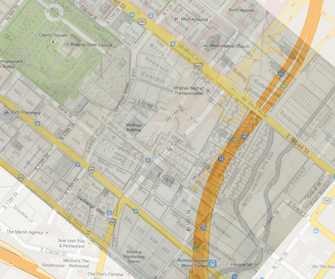 |
Roughly aligned composite map illustrating the discussion. Shows current
conditions overlaid on the Mijacah Bates map of 1835. The burial ground, wherever it was placed on the public land, could have projected to the east as far out as the curves of the old bed of Shockoe Creek permitted. North is to the top.
|
 |
Overlay of the 1835 Bates Map with the boundaries of city's tract shown in red. The southeast edge that was formed by the creek is approximate. |
 |
| Similar overlay on the 1889 Baist Atlas Map produced by the online Baist Atlas Project at VCU libraries. This shows the jail and school, but also shows another City of Richmond tract nearby. This would have been mostly on the east side of Shockoe Creek before it was straightened. |
Richmond’s new City Jail occupied a terrace
that comprised the entire southern section of the city’s property,
about an acre in size. The commission advertised for bids and awarded the
contract for the jail to Curtis Carter, who completed it in the early months of
1830 [Common Hall Minutes, 14 July 1828]. The only alterations to the contract
were the need to remove earth from the uphill side of the “Jailor’s
Lodge” and the paving of the yard within
the walls of the jail and the jailor’s lodge. Jeffrey Ruggles
introduced the testimony of Ernest Walthall, who wrote an unusual memoir in
1908 called Hidden Things Brought to Light.
In talking about cemeteries
Walthall states, “In
digging foundation for old city jail there were signs of a burial place, and
the bones were so large they were classed giants’.” The
jail was built in 1830, and Walthall was not born until 1848, so this is a
story he heard from others.
Walthall’s account probably understates how many bones were found.
Old City Jail was located on Marshall Street, just west of 15th. There was much
digging when the jail was built. During the 1820s and 30s, as Richmond became
more urban, a number of terracing projects were undertaken on the slopes of Council Chamber
Hill and Shockoe Hill to create lots for development. One was for the jail. The
site preparation required that part of the hillside be dug away for the
structure, and then more excavation carved out a jail yard. On the west line of
the jail lot a tall stone wall held back the hillside, then the wall turned and
went a ways east on the south line of the lot [Jeffrey Ruggles, “The Burial Ground: an
early African-American site in Richmond: Notes on its history and location,” 2009].
New Uses for the Public Land
 |
| Modern Google Map overlay for 1835 Bates Map of Richnond, It shows the "Grave Yard for Free People of Colour" to the east of the Hebrew cemetery, joined on the east be a second burial are for "For Slaves." |
On 18 June, 1810 “sundry persons of colour” petitioned the Common Hall for new ground for a graveyard. The request was delegated to a committee to prepare a report. The Common Hall received the report and granted the request several months later [19 Oct. 1812]. It doesn’t appear that any action was taken until 1816, when the city established a new Negro Burying Ground (later shown as “Potters Field”) in a location near the Almshouse and what became Shockoe Cemetery. An inadequate and delayed response to the petition of 1810, the new burying ground included separate areas set aside for free blacks and slaves [Minutes of the Common Hall, Richmond, Vol. 5, p. 23 ; Richmond Enquirer, 22 Feb. 1816, cited in Jeffrey Ruggles, Burial Ground, 2009]. The venue for public executions moved along with the new Burial Ground in 1816. Later, a new powder magazine was built nearby, completing what seems to have been a full recreation of the earlier site. The new burial ground for free persons of color is located on the flat area to the northeast of the intersection of Fifth and Hospital streets. Slaves were buried in an area set aside along the bluff above the creek, as can be seen in the 1835 map above. At the end of the Civil War, free and enslaved was no longer a category and the two cemeteries were combined and expanded around the north side of the bluff. It was now labeled Potters Field.
 |
| The Potters Field shown on the Beers Map of 1877. Fifth Street has since cut through the Potter's Field to run over Bacon's Quarter Branch on a viaduct and he hillside has bee reshaped in relation to the railroad tracks that run at the bottom. |
 |
| Map showing size in 1876, when free and non-free sections of the 1816 Negro Burial Ground was shown as the "Potters Field." |
All across the nation, African Americans of all conditions were forced indiscriminately into “potter’s fields,” the traditional name for a graveyard for outsiders and paupers, together with indigents and criminals. Pressing for improved burial conditions was one of the first ways in which African Americans attempted to give an independent voice to their political aspirations [Archaeological Investigations of the Mother Bethel Burying Ground http://www.phila.gov/ParksandRecreation/PDF/Bethel%20Burying%20Ground%20Appendices.pdf]. In Richmond, free blacks followed a pattern familiar to other cities, when they used their only avenue for redress and asked the Common Hall to provide a dignified place for burial.
 |
| City Jail and repurposed Lancastrian School seen at center bottom of Sanborn Map of 1924. Note the curve of Shockoe Creek to the northeast. |
The building of the Lancastrian School in 1816 and the selection of the tract as the site for a new jail coincides precisely with the establishment of the new Negro Burying Ground. There is no record of what happened to the remains of those buried in the burying ground. If their remains were mostly confined to the area of the jail and school, then they were either deposited with the fill that was removed or perhaps moved to the new potters’ field. This seems to expand on Christopher McPherson’s prediction in 1810 that, since “many graves are on private property adjoining, [they are] liable to be taken up and thrown away, whenever the ground is wanted by its owners, (this is owing, either to confined space, or want of knowledge of what was public ground).
A group of six free blacks had made a similar request of the Philadelphia government to consider establishing a burying ground separate from the common potter’s field as early as 1782. As many as a dozen of these burying grounds have been identified in Philadelphia, most of which were ignored by later development. The abandonment of potter’s fields without relocation of the graves was widespread in densely settled cities. With no advocate able to defend their memories, only a few were exhumed and reburied.
The new land was no more suitable for burial than the former: a contemporary account by Frederick Law Olmstead describes its location along a “crumbling bank” and its “graves ascending in irregular terraces up the hill-side” [Olmstead, Cotton Kingdom, 1861, quoted in Veronica A. Davis, Here I lay my Burden Down: A History of the Black Cemeteries of Richmond, Virginia (Richmond: Dietz Press, 2012)].
Sunday, October 18, 2015
PUBLIC ART AND COMMUNITY MEMORY- RICHMOND'S MAGGIE LENA WALKER, PART II
"Urban Scale Richmond takes as its focus the rediscovery of the rules, both explicit and implicit, that have guided the building of the city and give to its art and architecture a unique character. One way to achieve this result (and to reduce the diminution of local conventions and the disempowerment of citizens) is for planners to actively reconstruct the city’s operative patterns. The way in which monuments proceed from a nexus of community expectations is an important part of those patterns. By engaging critically with local issues, it will be possible to confirm and stimulate healthy growth and change in the city.
The way in which monuments are procured has an effect on the quality of their 'fit,' although there is no consensus on the best way to control the process. The most complicated part of making a monument is in connecting it in some tangible way, not only with local tradition, but with the expectations of the various constituencies for which it is intended. This is only achieved through careful consideration of location, materials, scale, form, and viewer expectations. Urbanismo hopes for the best!"
 This is how we ended our previous post on Public Art and Community Memory: Richmond's Maggie Lena Walker, expressing our concerns the commemorative public art proposed to honor Richmond's Maggie L. Walker . We were apprehensive that the Public Art Commission would guide the designer selection process away from the kind of engagement with the past seemingly favored by the community. A year and a half later, the process described in the post has been completed and we have very good news to report. The city's Public Art Commission announced last week that the commission would be for a statue and that the artist would be prominent American representational sculptor Antonio Tobias Mendez. Mendez, with a BFA from the Chicago Art Institute, does sports, commemorative, private commissions, and veteran's memorials.
Mayor Dwight Jones announced the decision: “Not only will Richmond gain an important new monument that can reflect the diverse heritage and history of a significant local hero, but this effort will also underscore her role as a champion for civil rights on the national landscape,” said Mayor Jones in a press release. “Maggie Walker was a revolutionary leader in business, a champion for breaking down barriers between communities and showed incredible strength as a person that came out of extraordinarily challenging circumstances to create great things.”
The location of the monument will be in the triangular plot at the intersection of Adams Street and Broad Street, an important node on the urban scale, where the 18th-century road called Brook Turnpike engages at an angle with the city grid. This was formerly the site where a fountain was provided to water the horses and oxen drawing wagons and drays as they entered the city (that fountain is now located behind the Bill "Bojangles" Robinson Statue a few blocks to the north. The historic intersection was a key location in Maggie Walker's world and remains a very memorable node in the city's transportation network. The new statue begins to reinforce an established civic armature. This begins at Franklin and Adams and moves from Maggie Walker's statue at Adams and Broad to the Bojangles statue and beyond.
This commission bodes well for the Maggie L. Walker Monument to join with many others, including the George Washington Monument and the Civil Rights Monument at Capital Square. As we previously observed, that "sculptural ensemble by Stanley Bleifeld avoids the sentimentality that characterizes some of the sculptor's work in other cities and takes a place among the very best monuments of recent decades." Let's hope the Maggie L. Walker Monument will achieve the same levels of formal and emotional strength, and by doing so, help re-establish the legitimacy of figurative public art.
This seriousness should extend to the setting as well as the bronze centerpiece. Mendez's website indicates that "Toby primarily focuses on the figure, combining a classical figurative approach with a contemporary eye for site design." In monument-rich Richmond, the plinth says a great deal about the position of the subject in the city's historical narrative. Offering a sense of "approachability" by placing the statue on the same plane as the viewer has become a hackneyed trope. Maggie Walker, who pointed the way for her community, often from a position on her elevated front porch, would best occupy a raised podium equipped with moldings and set off by appropriate ornament. The setting should support and embrace the statue without seating, planting, or paving elements that draw attention to themselves or work against the city's conventional landscape patterns.
Congratulations to the entire community and the arts commission for making decisions that will contribute to a deeper understanding of Maggie Walker as leader, embodying the civic values she espoused throughout her life.
The way in which monuments are procured has an effect on the quality of their 'fit,' although there is no consensus on the best way to control the process. The most complicated part of making a monument is in connecting it in some tangible way, not only with local tradition, but with the expectations of the various constituencies for which it is intended. This is only achieved through careful consideration of location, materials, scale, form, and viewer expectations. Urbanismo hopes for the best!"

Mayor Dwight Jones announced the decision: “Not only will Richmond gain an important new monument that can reflect the diverse heritage and history of a significant local hero, but this effort will also underscore her role as a champion for civil rights on the national landscape,” said Mayor Jones in a press release. “Maggie Walker was a revolutionary leader in business, a champion for breaking down barriers between communities and showed incredible strength as a person that came out of extraordinarily challenging circumstances to create great things.”
The location of the monument will be in the triangular plot at the intersection of Adams Street and Broad Street, an important node on the urban scale, where the 18th-century road called Brook Turnpike engages at an angle with the city grid. This was formerly the site where a fountain was provided to water the horses and oxen drawing wagons and drays as they entered the city (that fountain is now located behind the Bill "Bojangles" Robinson Statue a few blocks to the north. The historic intersection was a key location in Maggie Walker's world and remains a very memorable node in the city's transportation network. The new statue begins to reinforce an established civic armature. This begins at Franklin and Adams and moves from Maggie Walker's statue at Adams and Broad to the Bojangles statue and beyond.
This commission bodes well for the Maggie L. Walker Monument to join with many others, including the George Washington Monument and the Civil Rights Monument at Capital Square. As we previously observed, that "sculptural ensemble by Stanley Bleifeld avoids the sentimentality that characterizes some of the sculptor's work in other cities and takes a place among the very best monuments of recent decades." Let's hope the Maggie L. Walker Monument will achieve the same levels of formal and emotional strength, and by doing so, help re-establish the legitimacy of figurative public art.
This seriousness should extend to the setting as well as the bronze centerpiece. Mendez's website indicates that "Toby primarily focuses on the figure, combining a classical figurative approach with a contemporary eye for site design." In monument-rich Richmond, the plinth says a great deal about the position of the subject in the city's historical narrative. Offering a sense of "approachability" by placing the statue on the same plane as the viewer has become a hackneyed trope. Maggie Walker, who pointed the way for her community, often from a position on her elevated front porch, would best occupy a raised podium equipped with moldings and set off by appropriate ornament. The setting should support and embrace the statue without seating, planting, or paving elements that draw attention to themselves or work against the city's conventional landscape patterns.
Congratulations to the entire community and the arts commission for making decisions that will contribute to a deeper understanding of Maggie Walker as leader, embodying the civic values she espoused throughout her life.
Thursday, July 16, 2015
Civic Markers II: Monuments as Ordering Elements in the City
"The status of monuments on the cusp of the twenty-first century is double-edged and fraught with an essential tension: outside of those nations with totalitarian pasts, the public and governmental hunger for traditional, self-aggrandizing monuments is matched only by the contemporary artists’ skepticism of the monument"
James E. Young, “Memory/Monument,” 2010
 |
| Lord Botetourt |

As Charles Brownell and his student Ramin Saadat asked, why, at the Virginia Capitol, had Jefferson "devised a templelike exterior and a templelike core surrounding a white marble statue in a fashion suggesting divine honors?” The answer, they suggest, may lie in the popular theory, known as Euhemerism, that saw the origin of ancient gods in mortal “leaders or benefactors” whose veneration had “naively evolved into worship.”
It
became necessary to call upon at least a modicum of myth in order to
craft an aestheticized history that met the new nation’s ideological
needs. . . . “American” versions of the methods by which Italy’s
Renaissance packed the past with rich meanings eventually found their
way into the national imagination, especially after the rising
commitment to manifest destiny began to overlay republican modesty with
grandiose images of heroic glory. But in the beginning the Capitol dealt
with America’s first president in its own way. By a reversal of the
euhemeristic tradition, as we will see in the making of the myth of
George Washington, the mortal man became a demigod.
George
Washington as America’s savior general and first president would endow
the nation’s capital with what Renaissance Italy named civile-
“the affective identification of the [citizen] with a particular,
geographically defined place,” as well as “a belief in the sacred nature
of institutions and leaders, an attitude that invests things and
persons political with a mystical aura, distinguishing them from mundane
structures and from ordinary mortals.”
Public
ceremonies required the right person to represent the nature of the
republican virtues Americans were making up as they went along. . . . In
both the Old World and the new, ceremonies of adventus sealed the
relation of leaders to the people (private individuals, the military,
the administrative staffs). They confirmed the needed sense of stability
and order, backed by a coherent bureaucratic system. Over time,
however, it became unnecessary to highlight the “action” by which a
leader “arrives.” He is “just there” through a process that has been
“completed and consummated.” . . . John Quincy Adams was deeply
depressed by the implications of the inability to reach a compromise
over the final resting place of the nation’s foremost symbol of unity.
In his diary of February 22, 1832, Adams wrote that the wish for the
capitol to be the site of Washington’s tomb had been “connected with an
imagination that this federal Union was to last for ages. I now
disbelieve its duration for twenty years, and doubt its continuance for
five. It is falling into the sear and yellow leaf” [Martha Banta, One True Theory and the Quest for an American Aesthetic (Yale U Press, 2007, 77ff].
 |
| Thomas Crawford's equestrian Washington, 1858 |

The monumental composition stands on a granite base appropriately shaped like a hexagonal star fortress. The design includes two tiers of supporting sculptures around a massive bronze equestrian figure of Washington, cast in Germany. The upper row of pedestals support statues of six Virginia patriots- Thomas Jefferson, George Mason, John Marshall, Andrew Lewis, Thomas Nelson, and Patrick Henry. The lowest tier consisted of six allegorical female figures and trophies representing revolutionary virtues (and places) allied with the six patriots. Andrew Lewis is allied with “colonial times,” Patrick Henry with revolution, George Mason with the Bill of Rights, Thomas Jefferson with independence, Thomas Nelson with finance, and John Marshall with justice. Crawford died having completed only the sculptures of Washington, Jefferson, and Henry. His student, Randolph Rogers, completed the remaining pedestal sculptures after the Civil War. The monument strongly reinforces the urban order by serving as a objective at the end of Grace Street at the entrance to Capitol Square. It stands on axis with the Governor’s Mansion and in an effective non-axial introductory relationship with the Capitol itself. The nearby Washington Tavern was renamed the Monumental Tavern in its honor [Hopson Goddin, Richmond Virginia 1861- 1865, Civil War Centennial Committee, 1961].
 |
| Henry Clay Statue under the octagonal canopy, 1860 |

A life-sized statue of Thomas J. “Stonewall” Jackson was placed nearby in 1875, beginning a line of monuments that would be erected in the twentieth century along the northern edge of the square. The bronze sculpture was made in 1875 by Irish sculptor John Henry Foley and was the gift of “English gentlemen as a tribute of admiration.”
Monument Avenue was laid out in 1887, not only to serve as an appropriate setting for the heroic statue of Robert E. Lee planned to stand at the center of a great circle at its eastern end, but as a grand extension of the city to the west.
As was documented by Jay Killian Bowman Williams, Monument Avenue was largely the creation of its property owners, beginning with the Allen family, who owned the site of Lee Circle. The city and most of the promoters of the statue wanted it to be placed in a familiar and existing location such as Capitol Square, Libby Hill, or Monroe Park. The Board of the Lee Memorial Association, having been convinced by, among others, Augustus St. Gaudens, that an accomplished European sculptor would produce the best work, hired Frenchman Jean Antoine Mercier and mandated a calm, serene Lee who would project a sense of the moral and aesthetic seriousness of the southern cause missing in the booming New South city that doubled in size between 1860 and 1890 [Jay Killian Bowman Williams, Changed Views and Unforeseen Prosperity: Richmond of 1890 Gets a
Monument to Lee (Richmond: privately printed, 1969)].
 |
| A famous image of the Lee Monument, with a crop of tobacco growing in front of it. This has always looked to us like a a publicity stunt. |
 |
| Monument Avenue looking west from Stuart Circle |
 |
| Soldiers and Sailors Monument by William Ludwell Sheppard, 1894 |
 |
| A triumphal arch constructed as a temporary entry gateway to the popular Street Carnival held on Broad Street in 1900. |
 |
"Triumphal" arch in stone proposed for Monroe Park soon after Jefferson Davis' death in 1889. An arch was again suggested to span Broad Street in 1901 [City on the James, 1893]. |
 |
| First Regiment of Virginia Monument at Park Stuart and Meadow streets by Ferruccio Legnaioli |
A tradition began of placing statues at key points around the city, begun by Cutshaw, continued to punctuate the axes of transportation routes and along paths in public parks. These include the statue of A.P. Hill at Laburnum and Hermitage and the figure of Williams Carter Wickham (1820 –1888), a lawyer, judge, politician, and Confederate Cavalry commander, who image was placed in Monroe Park by his war-time comrades and employees at the Chesapeake and Ohio Railway in 1891. It was sculpted by Richmond’s Edward V. Valentine. The Richmond Howizers Monument (1892) and the Monument to the First Regiment of Virginia Infantry (1930) punctuate the irregular route of Park Avenue as it wends its way through the Fan District.

Columbus statue and fountain
As the Fan District was extended to the west, Boulevard was laid out in 1875 as a grand cross street to connect Reservoir (Byrd) Park to Broad Street. The terminus at the foot of the great reservoir was given an suitably architectural effect by the placement of a small cascade fountain symbolizing the civic provision of water fronted by a statue of Columbus. This was placed in front of the fountain in 1925 by a group of citizens of Italian origin and sculpted by immigrant sculptor Ferruccio Legnaioli.
The discourse on Richmond's Civic Markers will continue with Part III- Fountains.
For a discussion of contemporary monumental art, see Public Art and Community Memory: Richmond's Maggie Lena Walker.
Subscribe to:
Posts (Atom)



