“First, What kind of life was lived in this place, that is, Why and how did its builders build as they did?
And second, what rules with general validity and applicability did they follow?”
Carroll William Westfall, Learning From Pompeii.


Friday, June 28, 2019

Villas on the Hill: Richmond's Richard Adams and Adams-Taylor Houses


Richmond Hill, Richmond's ecumenical retreat center, occupies a spectacular site on the forward edge of the city's Church Hill neighborhood, overlooking the downtown to the west and the James River to the south.  The complex of brick buildings is embedded in a beautifully maintained walled garden that dates back to the late eighteenth century. Richmond Hill's history mirrors that of the city. We developed this text as part of a historic structure report for the Richmond Hill community prepared at Glave and Holmes Architecture.
 
Overview
 
The site was first developed in the 1780s by Col. Richard Adams (1726-1800), a member of the House of Burgesses, the Virginia House of Delegates and Senate and was a delegate to the Convention of 1776. In 1769, Adams purchased several squares on Richmond Hill, as well as parcels of land to the northeast, from Isaac Coles, which he called Spring Garden. Over time, members of the Adams family built several houses on the crest of Church Hill which were incorporated into the Richmond Hill complex after the properties were purchased for the Sisters of the Visitation soon after the end of the Civil War. They converted the old Adams houses for use as a convent and school, which they called Monte Maria. Eventually constructed a chapel and dormitory/convent. After years of prayerful life in the monastic tradition, the sisters moved to a new location, opening the opportunity for the ecumenical Richmond Hill community to purchase and thoroughly rehabilitate the complex and garden to serve as a training and retreat center.


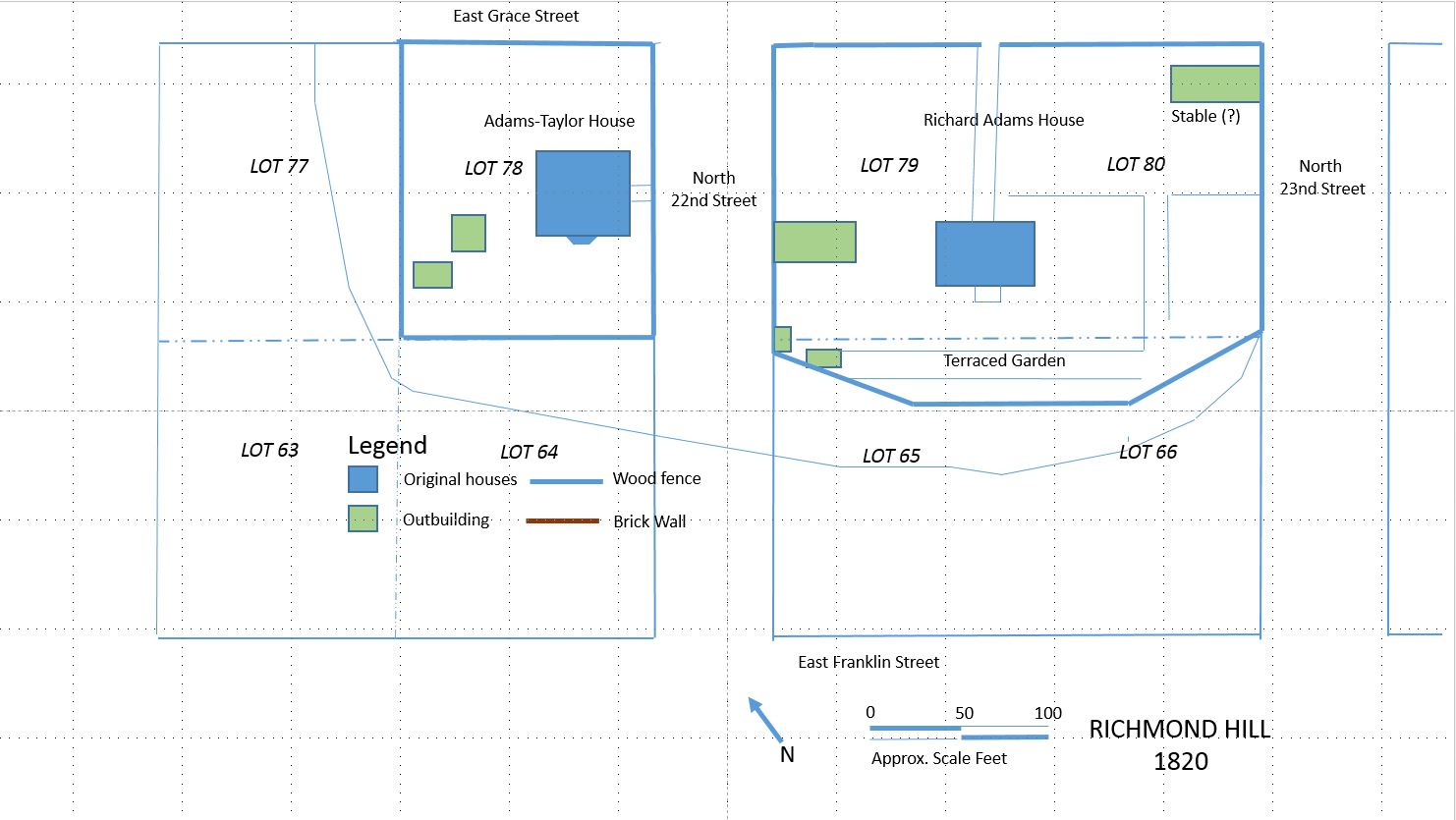
The two "squares" or blocks occupied by the Richard Adams and Adams-Taylor Houses as they were probably
arranged in 1820. The lower half each square forms the bluff and drops sharply to the lower part of town. The view
to the James River is to the south.
The same site today, showing the buildings added by the Sisters of the Visitation and the Richmond Hill
Ecumenical Center from 1866 to the present.
 
Site History
 
The northeast corner of the 28-block grid of the town of Richmond, laid out for William Byrd II in 1737, was difficult of access and remained undeveloped for many years. Byrd convinced the vestry of Henrico Parish to place their proposed new upper church at Richmond on two prominently placed, but marginal, lots at the highest point on what was then known as Indian Town Hill, overlooking and dominating the lower town. The grid along the south side of the hill was so arranged that Franklin Street ran along the bottom of the hill and Grace Street at enough distance back from the top that there was room for houses and gardens.

The land around the church was not developed for many years. The original owner of much of the land on the hill was John Coles, (d. 1747) a prominent merchant and planter who emigrated from Ireland in the early to mid-1730s. He owned lots on the hill and two of Byrd's suburban “villa tracts,” totaling nearly 28 acres, located to the north of the town.


In 1769, Coles’ son Isaac Coles (1747-1813) sold his holdings, including 10 half-acre lots, to Col. Richard Adams (1726-1802), a mill-owner and land speculator in Richmond. Adams, born in New Kent County, was said to have been “one of the most enterprising, public-spirited, wealthy, and influential citizens of Richmond”  [Coleman, C.W. Genealogy of the Adams Family of New Kent and Henrico Counties, VA, William and Mary Quarterly 5:3 (Jan. 1897) 161-62]. He hoped to persuade Thomas Jefferson to locate the new capitol on his land on Church Hill and on the tract to the north, which he called Spring Garden, which he had laid out in lots. Legend has it that he was resentful that Jefferson chose Shockoe Hill to the west instead.

Richard Adams House [Scott 1941].


RICHARD ADAMS HOUSE (c1790)
 
Col. Richard Adams built a large, one-story frame house on the square south of Grace Street between 22nd and 23rd Streets about 1790. Its exact date of construction is not certain. According to Mary Wingfield Scott, “the seat of a Mr. Adams was mentioned in a travel book published in 1784 [Smyth’s Tour in the United States] probably refers to an earlier house on the north side of Grace, possibly built for John Coles [Scott 1941]. Land tax books as late as 1788 show the lots as unimproved. A Virginia Mutual Assurance Society policy dated 1796 is for a house “all wood. . . two stories. . . .55 feet by 34 feet. . . . kitchen 28 feet by 18 feet northwest of house” [Scott 1950].

The original house appears to have been a one-story, frame, U-shaped center-passage-plan dwelling with a half upper story served by dormers, but the house was enlarged over time to the north. A central porch stood at the south entry. Massive two-story exterior chimneys with tiled shoulders stood at each end (the western chimney was removed when as addition was made to the west). The roof appears to have projected to form matching ells that extended to each side of the north entry, each with an exterior chimney on the north end. At some point around 1800, the space between the ells was infilled with a two-story three-bay north addition with the appearance of a respectable small Federal town house. This addition effectively updated the appearance of the house from the street. The roof of the two-story section fit neatly on top of the eighteen-century portion to give it the appearance of a hip-on-hip roof from the south. The north addition was entered through a delicate, central, three-bay entry porch [photos at the Valentine].

Middle terrace of the historic garden along the south front, looking east.
 

A terraced garden, of the type known as at the time as "falling gardens," appears to have extended along the south and possibly the east sides of the house. Three shallow terraces aligned with the river that survive in the existing garden very likely date from the eighteenth-century Adams garden. The fine quality of Richard Adams’ garden was a memory passed down by the later owners [Goodpasture, 1999]. A sense of the terraces can be seen in the 1889 view of the house (Figure 12). The family grew some foodstuffs on a lot nearby. The will left by his son, Richard Adams, Jr., mentions four enclosed lots that he used as a garden, probably close by the house.

Baist Map of 1889. The Richard Adams House is shown in yellow beside the number 79
and the Adams-Taylor House beside the number 78.
Outbuildings on the site include the two-story, “slave quarters” visible in early photos to the west of the house and identified by the nuns [Sentinel on the Hill, 24]. This is identified as a brick building on the 1889 Baist Map of the city. Other structures that appear on maps from the late 19th and early 20th centuries may or may not date from the Adams period. A two-story brick outbuilding stood near the northeast corner of the lot (near the number 80). Portions of it, including a small tool shed and bricked-up window, still remain incorporated into the perimeter wall. It may have been a stable or carriage house for the Adams or, at a later date, Ellett families.


Until the early nineteenth century, there were few dwellings other than the Richard Adams House and several houses of his children, aligned along the edges of the bluff overlooking the James River and Shockoe Creek. One son, Dr. John Adams, lived to the east. Richard Adams Jr. (1760-1817), a wealthy land speculator like his father, received the original family home. A two-story frame addition was made to the west end of the old house, probably by Richard Adams, Jr.

After the death of Col. Richard Adams in 1802, the Adams family began selling off lots in the neighborhood and new buildings began to appear along Franklin, Grace, and Broad streets. When Richard Adams, Jr. died in 1817, he left the “the old mansion house, and two lots immediately attached thereto and the four lots now used and enclosed as my garden” to his nephew Richard Adams III. He sold the house and lots 79 and 80 to Loftin N. Elliett, Clerk of the Henrico County Court, in 1825.
Casimir Bohn. Richmond from the church hill, 1851 [Library of Congress]. The Adams-Taylor House is shown in the foreground. The view is from the east.
ADAMS-TAYLOR HOUSE (1812, 1859)
 
This remarkable, but much-altered house is usually said to have been built by Richard Adams, Jr., who had been mayor of the city in the 1780s. It appears, instead, to have been built for speculator James Smith in 1812. Until 1808, lot 78, which later contained the house, was listed as unimproved and assessed against Richard Adams at $100. In 1810, the value increased to $500. In the following year Adams’ four lots on the square were valued at the relatively modest sum of $2,000. By 1813, lot 78 was accessed for the large sum of $6,500 against James Smith, who was recorded as the tenant. This undoubtedly represents the value of a grand new “mansion house.” Smith built the house with the backing of Richard Adams, Jr. and his brother John Adams. They had joined Smith in 1814 to insure the expensive new brick dwelling in 1814 for $6,000 [Virginia Mutual policy]. Smith received the title to the property in March of 1814 [Deed Book 10, p. 478].

Conjectural floor plan showing the main floor of the building c 1900, when it was used as the Monte Maria Academy. The original room layout survives along the south front (at top). A passage originally spanned at the center from east to west.
The entry tower at the east side and the stairs in the SW corner were added and the open plan along the north front created
by removing earlier partitions. Since that time, Richmond Hill has subdivided that area once again.
It was acquired for $13,000 by Jacob Galt Ege after Smith’s death in 1817. The severe depression of 1819 brought to an end a period of rampant speculation and price inflation in Richmond real estate. Ege was forced to transfer the property to his mother-in-law, Diana Morgan. Diana Morgan returned the house to Jacob and Jane Ege with the understanding that it would be sold for the benefit of their heirs at their deaths [DB 15, p. 443]. Jacob Ege insured it for $5,000 in 1822 and 1829. The house was sold by court order to William W. Palmer (1801-1870), a native of Maryland, in 1833 [DB 32, p. 95]. It was reevaluated at $3,500 for insurance in 1836 and 1851. It decreased in value in 1858, when once again re-valued. Palmer was a dealer in agricultural implements, seeds and farm supplies, insurance, and banking. He was a director and vice President of the Richmond and Danville Railroad Co. His wife was Elizabeth Walker Enders, daughter of John Enders, a prominent tobacco dealer [Montgomery [Virginia] News-Messenger, 1 July 1976 and gravestone, Hollywood Cemetery].

A wide entry at the center of the north front, now altered, can be seen obliquely in the drawing of 1851. The house may have been intended to face Grace Street, in which case visitors were supposed to be received in a central hall on the first floor at the center of the north front. The north entry was not, however, accessible by stair in 1851. A formal secondary entrance on the east side, facing the older Adams family home, opened into a transverse passage that ran from east to west. The east entry was provided with an elegant Federal frontispiece and accessed by an elegant stone stair with an iron railing (Figure 7). The west end of the house was likely the service end of the dwelling.


Historic photo of the Adams-Taylor House, early 20th c. Note how the center three bays on the second floor are grouped together, probably reflecting the

 existing of a large central room on each floor. This may have been a stair hall. A pair of doors has been added to reach the two rooms that occupied that space.
 The porch at the west end may have provided service access. The chimneys that served the northern row of rooms had been removed by this point. Note the
paneled end of the chimney that remains. The two-story former slave quarters between the two Adams houses was still in place.

In 1859, Palmer sold the house to William Taylor [DB 74B, p. 124]. William Taylor, one of the city’s most successful wholesale merchants, purchased the house and greatly enlarged it about 1859. He dramatically increased its value by adding a second story with a central cupola and porticoes on both the north and south. The exterior was covered with stucco. The south portico extended across both floors on massive square columns, a feature that was popular among Richmond's wealthy land-owners, permitting them take the most advantage of shade and air in the summer and of the dramatic views possible on the hills of the city. The exterior openings were much altered in 1859. Only a small amount of original trim remains in the house.

North front of the Adams-Taylor House, 2001 [Frazier Associates]. The added stair/bell tower is to the left. The central cupola was removed but has since been restored.
North Front of the Adams-Taylor House

South front of the Adams-Taylor House 


Pontoon Bridges across the James River, Detail, 1865, Library of Congress. The Richard Adams House is at the right and the Adams-

Taylor House is near the center. A long two-story frame outbuilding stands to the west end of the Richard Adams House. Separate boundaries
of wood fencing can be seen surrounding both the Richard Dams and the Adams-Taylor houses.
In 1860, William Taylor sold the house to Richard A. Wilkins, a Virginian returning from Louisiana to educate his children in Richmond [DB 76A, p. 1]. A plain one-story porch protected service entries on the west side of the house on the basement and first-floor levels. Two one-story outbuildings were located nearby to the west of the house.
 
 
Adams-Taylor House. Original first-floor door trim between south-central room and southeast room (left) and original stair and rail on east front, now inside entry tower (right).
 
On the interior, some of the Federal-style woodwork appears to have been retained by Taylor. A single door survives from the original house on the first floor. More was probably present until the late-19th-century alterations which made the house into a school. Very little material from this period survives on the first floor. The mantels on the first floor in the south central and southwest rooms were replaced with plain Greek Revival period wood elements dating from this period. On the second floor, the windows and window trim dates from 1858.
CONVERSION TO SCHOOL USE
 
Loftin N. Ellett, owner of the Richard Adams House, also acquired portions of the adjacent lots 65 and 66 in 1861. After his death in 1862, in 1866, his executor sold the Richard Adams property to Bishop John McGill, Bishop of the Roman Catholic Diocese of Richmond. Bishop McGill had requested that a convent be established in Richmond by the Sisters of the Visitation of Holy Mary to provide the diocese with an important missing element- a cloistered monastery. The Visitation Monastery in Baltimore sent six nuns for that purpose.
 
 
In the same year the diocese purchased the Adams-Taylor House from Richard Wilkins [DB 83B, p. 232]. The bishop's intent was to establish a school for girls to be operated by the convent as a means for supporting their vocation. The interesting story of the Monte Maria Academy will be told in a later post.


Friday, February 15, 2019

Emancipation Monument: A Proposal

As is well known, Richmond has been the scene of an extended conversation- sometimes extreme in its terms- about the city's monuments, particularly those placed along Monument Avenue, the city's renowned boulevard traditionally dedicated to Confederate generals. We reviewed the larger monumental tradition in Richmond some time ago, before the topic took center stage. The mayor has been alternately in favor of some sort of retention and removal of the Confederate monuments. The governor has recently come out in favor of removal of the monuments from the street to a museum.   

Richmond's local History Museum, the Valentine, has sponsored a competition and exhibit around proposed solutions to the controversy.  One of the members of my firm, Stephen Hershey, entered a classical proposal in the competition. He proposed leaving some or all of the existing monuments in place and answering them with an imposing new classical structure incorporating monumental sculpture. As might be expected, it was not selected to be shown in the exhibit.   

Here is his description and a proposed set of guidelines, which outline a significant formal representation, in keeping with classical principles, of the sacrifices and achievements of the many individuals who acted in favor of emancipation. It places on the avenue a counter-statement that rises to and perhaps surpasses the old monuments, transforming the meaning of the street for the benefit of the entire city, not just the fraction of its citizens who idolized the Confederate heroes.

 _________________________________________________________________
 
Monument to Emancipation
 
The Monument to Emancipation is dedicated to native Virginians who opposed slavery before and during the Civil War. Abolitionists in Virginia, like Mary Bowser and Elizabeth Van Lew, played a pivotal role as spies during the War, gathering and relaying Confederate secrets to the Union. African Americans from Virginia like William Harvey Carney, the first African American Medal of Honor recipient, played an important role on the battlefront. Often unheralded, the Monument to Emancipation gives these individuals a prominent position on Monument Avenue, filling a gap between the Jefferson Davis and Robert E. Lee statues. This proposal is intended to help establish criteria for future monuments. The goal is to establish and maintain critical design guidelines that will preserve the beauty of Monument Avenue.
 
Design Criteria for Future Monuments
 
1.  Monuments should represent individuals over a broad spectrum of historical significance.
2. Preference should be given to native Virginians or individuals who made significant contributions to Virginia history.

3. Controversial figures (e.g. Jefferson Davis, Robert E. Lee, Nat Turner, Gabriel Prosser) should be represented on Monument Avenue based on their historical significance.

4. Monuments should reinforce the civic order, style, and organization of the street.

5. Monuments should be of similar size and scale to existing monuments. Variety is permitted but in good taste. The Monument to Emancipation is an example of a monument that solidifies its presence adjacent to the polarizing Davis and Lee statues.

6. Monuments should look like they belong to Monument Avenue. The original designers of the boulevard envisioned the future erection of additional monuments.


Thursday, January 3, 2019

Two Public Places Renewed

We here at Urbanismo have been fortunate to work on the designs for two of Richmond's most venerable public places, Monroe Park and the square that was historically occupied by the Richmond City (later Seventeenth Street) Market. The senior of us was employed at 3North, the architecture and planning firm that executed the master plan for Monroe Park in 2008.  Several years later, both of us were employed at StudioAmmons and produced a design project in response to a request for proposals from the City government for the Seventeenth Street Market Square. Although our design solution was not selected for the Seventeenth Street Market, we were hopeful that the final product would be as a sensitive to the underlying context carried by the site as the Monroe Park project turned out the be. Neither of us were involved in the implementation of either park.

Monroe Park, restored fountain looking north

We remain convinced that the best responses to urban interventions involve "excavating" the design solution from the site, carefully examining and weighing the value of the preexisting patterns at the site and making use of those patterns to give continuity and to avoid gratuitously and inharmoniously disrupting healthy urban and architectural patterns for generations to come. By this standard, the Monroe Park project receives high honors and the Seventeenth Street Market project fails miserably.    

The 2009 3North Design for Monroe was largely executed as shown in 2017-18, with the exception of the rill running from the fountain to the lower center.

Monroe Park

The Monroe Park Restoration has been nearly a decade in gestation, but finally opened late last year after nearly two years of being fenced off from the public.
 
Monroe Park soon after opening in October 2018. The restored Checkers House, occupied by a police station and coffee
shop. New lighting, walking surface, and terrace around the Checkers House.


Restored Checkers House from the north, Oct. 2018.

The result is worthy of celebration. The reopened park is truly a restoration of all that is best of a great urban amenity. Major paths are lined once again by allees or rows of matching trees. The concrete and asphalt paving of the park's paths, arranged in the complex radiating plan implemented in 1877 by city engineer Wilfred Cutshaw, has been replaced by firmly packed yet soft-to-the-foot fine gravel. The brick Checkers Building of 1939 has been restored, and a completely new, classical pavilion of openwork bronze has been erected at the SW corner of the park across from the Altria Theatre (the Mosque Theatre of 1927).

Monroe Park as it appeared at its peak in 1896. Seen from the east.
The park, founded in 1851, was one of a series of three “breathing places in the midst of the City or convenient to it,” acquired as essential civic amenities by the common council. Modeled on similar squares in Boston, Philadelphia, Baltimore, and New York, Richmond's ten-acre "Western Square" was designed to provide an open, green place for the health and comfort of the citizens. It took many years for it to be landscaped and improved.

It was not until after the end of the Civil War and after use as a fair grounds and military camp that it began to be used as a fair-weather promenade and visual amenity in direct competition with the city's original urban park at Capitol Square. The adjutant general of the US Army obtained funding to make modest improvements to the square in the early 1870s. In 1872, he donated a rock fountain at the center of the square. Charles Dimmock, the city engineer, prepared a plan of improvements for Monroe Square in 1871. and its gradual improvement commenced under his direction.

Elm trees and privet hedge along the Franklin Street side of Monroe Park [VCU Library]
It is surrounded (at least on two sides), as it likely was for many years, by American elms. According to the 2008 Master Plan researched by Tyler Potterfield, the planting plan begins an attempt to duplicate the wide range of textures and colors of trees and shrubs within the park. As planted between 1889 and 1904 by the city nurseryman, the park including maples, lindens, poplars, and elms. Some 62 trees representing 26 different tree species that were enumerated in an inventory of 1904 had, by 2008, been replaced by a total of 68 trees representing only eight species. The central "tazza" (tiered) fountain, made of cast iron and installed c 1906, and the statues of Confederate General Williams Carter Wickham (1891) and newspaper publisher Joseph Bryan (1911), as well as a brick World War II monument (1951), continue to face toward the park's periphery.

2004 VCU Master Plan- thankfully unexecuted design for a intensive intrusion into the grounds of Monroe Park
 from the west. Landscape designers and planners often seem unable to resist the desire to 'do something" like adding
 unnecessary plazas and "water features" that wok against the "parti" or design concept embedded in the park
 itself, eroding the clarity of its form 
By invisibly updating the park the city has demonstrated the greatest restraint at a time when subtlety in landscape design is in recession. The park support groups and the late Tyler Potterfield, senior planner, deserve great credit for the general preservation approach for the park. The project treated this great public amenity with the respect owed to the foresight of the designers preceded us. There was no need here for contemporary design features, intrusive public art, and superfluous elements like splash pads that pander to a supposed need to educate or entertain the public in order to convince them to make the fullest use of the park.  


Bryant Park, New York City, plan [above] and photo looking east [below]

The initial design by 3north, headed up by architect and landscape architect Jay Hugo, was to replicate the success of other urban plazas like Bryant Park in New York City, which reopened in 1992 as "programmed" park with provisions for eating, playing, and relaxing, including food, New York Public Library kiosks, boule courts with instructors, loose seating, and a wide range of seasonal activities.

3north- watercolor rendering of rill, 2009. 
Some of the features of the initial design were "value engineered" away, including the "rill," a fountain which ran down the center of the main cross path toward the James River from the central pool- reproducing the Mountain, Piedmont, and Tidewater- the three regions traversed by the river and ending in a pool for sailing toy boats. Also, a series of decorative pylons forming gateways at each park entrance and a low wall to accentuate a sense of enclosure originally provided by a circumferential fence and- a later replacement- privet hedge.

3north- watercolor rendering of the restored Checkers
House and the new café- very close to the project as executed, 2009.
The author was involved in the design of the rill, and also in the restoration of the Checkers House (the original park keeper's station) as a café and police station, and in the selection, with the City's architectural historian, Tyler Potterfield, of the varieties and layout of the recreated allees which line the major paths, based on the original tree layout. The logic of the plantings had been lost over the more than one hundred years since its planting and the park was characterized by a motley collection of trees some of which were unhealthy and, and in the case of the many hollies and magnolias, inappropriate for the use. 

View east through the park. October, 2018
Our connection with the project ended with the design phase and we have observed the slow progress of its realization from afar, hopefully. When we visited one beautiful week day, the park was occupied almost entirely by students from the nearby university, playing Frisbee, reading, or sampling the coffee. The concession operator explained that part of her duties were providing equipment for games, including bocce, chess, and table tennis. We vote this one of the nation's best and most understated park restorations.                   

Seventeenth Street Market  

"As well as the encroachment of commercial material in traditional urban spaces the understanding of urban values is also under threat from the type of commercial space common to the cities of the leading developed economies. . . . In this context the elements of public space are often appropriated as a component of the developer's armoury in creating a successful segment of the city, yet they are exclusive environments without the diversity which authentic urban situations contain as a matter of course." Eamonn Canniffe, The Politics of the Piazza: The History and Meaning of the Italian Square, Ashgate, 2008.

The “Market of the City of Richmond” was founded by city ordinance in 1782. We explored its history here and the threats to it here.

As we have explored in detail in this post, the proposed Seventeenth Street Market Square represents the sixth intervention at the site of Richmond’s historic city market. From its earliest days on the bank of Shockoe Creek, the City Market has been an accretionary, transformative place, changing its character with the changing shape of the city. The Market Square was originally placed on the edge of the settlement. One contemporary remembered the “green pasture” of the town's Common, which extended from the Market House down to Shockoe Creek. Eventually the area around the market was lined with shops and it took on a more enclosed form. 


Richmond City Market in 1814. Detail of Market House of 1794 from
Virginia Mutual Assurance Society policy. The three arches to the right were an addition.
Like its predecessors in Europe, Richmond's First Market Square embeds centuries of change and growth, although over time it assumed the form of a conventional enclosed square. In fact, American public places like First Market Square have traditionally embodied the kinds of urbane social and economic values that we usually associate with European plazas.  
1854 Market Hall

1913 Market Hall
The market, which began in the half-block between Main Street and Arch (Walnut) Alley, was extended over time as far as Grace Street, two blocks to the north. The Market Square was eventually surrounded by brick buildings housing grocers and butchers' shops. By 1853, the market building was judged by a city committee to be inadequate. The main section of the market was replaced an Italianate-style two-story building was likely designed by the City Engineer, W. McGill. This replaced, in turn, by three other structures in succession. The last market building was demolished in 2017 in order to create, for the first time, an open square on the same site.   


Shopping in 2013 for a Christmas wreath with Lucille Allen (seen at right above) and her son. 
With her sister, Rosa Fleming, she sold home-grown vegetables and
hand-made Christmas decorations on the market for more than fifty years. 
As part of the rich, bottom-up, market-driven development that has characterized the area along Shockoe Creek since the late seventeenth century, the area around the Seventeenth Street or First Market is an increasingly vital neighborhood in its own right. Given the loss of the historic market halls, most of what was significant about the market area was embedded in its street layout, its pavement, and its shape. The curbing, street pavement, and sidewalks carried its history as strongly as the buildings that surround it.

Preservation of these urban textures and forms was essential to provide continuity and context. There are subtle formal and historical distinctions that must be made in order to take full advantage of the gifts this valuable civic resource offers to the city. 

This place has been at the heart of commerce in Richmond for over two hundred years. Shockoe Valley, with its growing young population, should retain a vital market function, preferably with a number of traditional permanent stalls, not just temporary shelters. 

In contrast, the project's planners treated the square as a "festival marketplace"- a wide concourse leading from Main to Franklin and beyond. This kind of planning led them to treat the square as if it was just a link in a grand scheme seen from a privileged, bird’s eye perspective.

The square did not evolve as an open piazza. While the edges of the square are formed by building facades on the south, east, and west, there is no closure at the north. It is long and narrow and “leaky” at the corners. The square was meant to be filled with architecture. This does not mean that it couldn't be adapted for use as a piazza designed to serve the civic good. 

Third Building at Richmond’s First Market site plan from Sanborn Map of 1889. Photo of first state
(built 1854) below on left and with second-floor hall removed on the right. Note the arch in the tower at the center.

The Market Square consists of two historic sections. The earliest part of the present square is the southern half. Its legal boundaries laid out in 1792. It contained the two-story building that served as the market house, municipal building, assembly hall, records office, and seat of justice. This building was later rebuilt and expanded to the north as far as Franklin Street.
Detail from the 1865 panorama of the city of Richmond looking west from Church Hill [Library of Congress]. The cupola of Mason's Hall is center left. The market and its bell tower aligned with Arch Alley is seen behind it.
Most importantly, its two main sections were linked by a central archway in the form of a tower that spanned “Arch Alley” midway along the market, permitting movement from east to west across the square. The elongated form of the now-vanished market buildings is defined by the cobbled streets and the granite curbing, each of which dates to the heyday of the market in the nineteenth century. The market gradually extended all the way to Grace Street in a series of shed-like buildings that diminished as they moved north.

Arch Alley looking east before replacement of paving in the market square.
Early conceptual version of the market square design, relating to its proposed role as entrance concourse to the failed ball park scheme.
Design Rendering
As it nears completion in mid-winter 2018, the renovated Seventeenth Street Market Square presents a slickly commercial appeal. Although it is a considerable improvement over the early renderings from 2013, meaningless gestures like the wiggly "water feature" in that design continue to affirm the Modernist bona fides of the designer. Shifting checkerboard squares, each with grass and a tree, punctuate the concrete paving. The old market bell is placed at ground level in a sculptural circular frame. Conventional electric streetlights are overpowered by tall area lights.

Seventeenth Street Market in November 2018 nearing opening day.


Banning cars and trucks from travel along the existing streets through the square was a mistake. As the recent Richmond Downtown Master Plan indicates, areas without traffic do not feel safe, seem empty, and suffer commercially. "Pedestrianization” sounds humane, but, except in certain high density areas, it can be deadly to commerce. Cars underline the activity in the area and parked cars even make visitors feel safer on the sidewalks. 

Seventeenth Street Market Square nearing completion


The pavement in the square has been completely replaced in the name of handicapped access, but it has flattened out the sense of historical associations. As a historic district, existing pavement could have been maintained to the greatest degree possible, not only in the square , but along the adjacent streets where, in some cases, it is the principal reminder of the historic context. 

The organizing elements of the landscape could have been used to reinforce underlying historic patterns. For instance, a central walkway from north to south could represent the central aisle that defined each of the three previous market halls on the site. In contrast paving with one flat plane from one side reminds this visitor mostly of the city's outdoor suburban malls. 
As we said in 2013, by treating the project with the care it deserved, the Market Square could have become, once again, as flexible, serviceable, and exciting as any American public square or Italian piazza of today.