“First, What kind of life was lived in this place, that is, Why and how did its builders build as they did?
And second, what rules with general validity and applicability did they follow?”
Carroll William Westfall, Learning From Pompeii.


Showing posts with label William Byrd. Show all posts

Tuesday, May 5, 2015

Westward Ho: Watson's Tenement, Turpin's Addition, and the Development of Shockoe Hill


Watson Ho., Detail of Madison Map of 1818


As we have seen elsewhere, the plateau on top of Shockoe Hill was laid out in streets in 1768 and the approximately 90 full squares, each containing four 1/2-acre lots, and 16 half squares. This new town called Shockoe, part of the lands of William Byrd III, was incorporated into the city in the following year. The development on Shockoe Hill was slow to develop, but the area at the top of the hill attracted some merchants and overnight lodging at the top of the old County Road that entered Richmond from the east at Gillies Creek and connected the town to points east and west.  Maps show that the narrow, curving way that traversed Henrico from east to west (probably begun as an Indian path) climbed the bluff from Shockoe Creek to the top of the hill. It continued to the west in a path that roughly approximated H or Broad Street, but did not strictly obey the official guidelines of the grid.


Watsons Tenement on the inset map of Byrds Lottery on Richard Youngs 1809 Map of
 Richmond. This map originated in 1768 and includes the platted town of Shockoe west
 of the creek labeled Town Land.


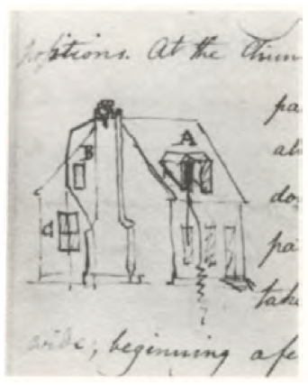
The tract of undeveloped land to the north and east of the County Road was known as Watsons Tenement. It had been leased by Philip Watson, merchant, from William Byrd III- the lease appears to have been renewed in 1757. It then comprised 128 acres and included, according to the lease of 1757, a brick dwelling where the said Philip now dwelleth, a brick store, and a frame granary. It seems likely that the brick house was the same as the one 1/2-story dwelling that later served as the Council House and the town residence of Col. John Mayo.  The appearance of that house is known from a sketch done in the notebook of B. Henry Latrobe in 1798, showing the damage done to it by a lightning strike. 

Detail of James Madison, A Map of Virginia 1807. The Philip Watson/Council Chamber
 House is seen to the right of the center fold, standing nearly alone at the top of the
 steep slopes of Council Chamber Hill.


The house apparently built for Philip
Watson, later the Council Chamber
from B. Henry Latrobe, Mayo
House, Notebook, 1798

Thomas Turpin purchased Watsons Tenement from William Byrd III [probably recorded in the General Court and now lost] as noted in a deed of 1783, when Turpin sold 93 1/2 acres, the remainder of the tenement after the sale of lots on the hill, to his son, Dr. Philip Turpin. The western section of the tract that was occupied by Watson was left blank on the plat of Shockoe that was made in 1768, north of Broad between Eighth and Twelfth streets. This section, later known as Turpins Addition and Court End, was laid out in lots and incorporated into the city by Thomas Turpin in 1780. The undeveloped remainder of Watsons Tenement ran east down to Shockoe Creek. The southern portion of this sloping land, containing Watsons brick residence, had been considerably improved and was valued by a jury at 4,000 lbs specie. The other half, to the north, where the Quesnay Academy,  Richmond Theatre, Baptist Meeting House, Medical College, City Jail, and Lancastrian School were to stand, was considered less valuable, assessed at only 1,000 lbs. 


Detail, Mijacah Bates 1835 Map of Richmond showing the area of the Burial Ground. The
 three lots extending west from 15th Street were the site of the residence of James
 Goodwin in 1807. The irregular lot on which the City Jail (1830) and the Lancastrian
 School (1816) are shown was public land on which a burial ground, gallows, and
 magazine could be placed.


The irregularity of Watsons Tenement as it sloped down from the eastern margin of the Shockoe Hill plateau meant that it was slow to be incorporated into the citys official grid. Probably as a result, parcels of land at the top of the hill were available for use by public institutions like schools (the Academy of Monsieur Quesney and the Medical College), a theater (the Richmond Theatre and the later Monumental Church), and churches (the Baptist Meeting House).  At some point, the city acquired a larger tract of between two and three acres spanning Franklin Street along the west side of the creek for civic purposes, including the eventual construction of the City Jail. Missing city records mean that it is difficult to say in what decade the city acquired the section from the Turpin heirs. Minutes of the Common Hall are missing from May of 1795 until January of 1808 and no mention of the acquisition is recorded in the deed books. The notorious sites associated with the practice of slavery, such as Lumpkins Jail and the slave auction houses were located on the part of Watsons Tenement along the creek to the south of Broad Street. 


Jefferson layout for the three Capitol squares, 1780, from Reps. Names of the original
 lots owners are shown.

Shockoe Hill was transformed by the arrival of state government. The 1779 act that relocated the capital to Richmond from Williamsburg authorized the Directors of Public Building to find a location for the government buildings in the open and airy part of the city. Two locations were proposed by the major landowners in two bluff-top locations: Shockoe Hill and Richmond [Church] Hill. In the following year the General Assembly authorized the appropriation of a site on Shockoe Hill for a new four-part government complex including a Capitol for the legislature, a Halls of Justice for the courts, a State House for the executive boards and committees, and a residence for the governor. Richard Adams, owner of much of the land on Richmond Hill, thought that he had Jeffersons promise and broke off his friendship when his proposal of twelve lots for the public buildings on Richmond Hill was rejected.


The process of valuing the land to be requisitioned for public use on Shockoe Hill began in 1783. The present site of Capitol Square seems to have been considered from the first, but two tracts that were also considered for taking comprised an area of thirty acres that was part of the former Watson Tenement. This parcel belonged to Horatio Turpin and his brother Dr. Philip Turpin, sons of Thomas Turpin, Thomas Jeffersons uncle. It was located on Council Chamber Hill, to the east of the County Road [Governor Street]. Owing to the loss of records, including those pertaining to the General Court in Williamsburg, where the Byrds recorded most of their transactions, the history of the property is vague. As we have seen, the Turpins acquired Watsons Tenement in its entirety after the lease was vacated, well before 1779. It was in that year that Thomas Jefferson, during his term as governor, occupied a house near the corner of Thirteenth and Broad belonging to Thomas Turpin.   

1768 plat of the Town of Shockoe as found among Jefferson's papers with
 undifferentiated grid pattern. The pre-existing tenements (including the very large 
extent of Watson's Tenement) and lots along Shockoe Creek are shown at the right.  

Horatio Turpin, deemed the owner of the lots most valuable for public use, offered the thirty acres on the Council Chamber Hill for sale to the state and, for free, two 1/2 acres of land that were part of the tract.  It included the compact brick building identified as the house now used by the executive, known as the council chamber. This was offered to the state as the site for the governors house [Journal of the House of Delegates 27 June 1783].  This parcel, later the home of  John Mayo, would have made an excellent and scenic location for the executive mansion. It was later proposed as the site of a villa for the Mayos by B. Henry Latrobe.


Other lots were valued as well from 1781 to 1784. These included all the lots that would make up Capitol Square. Most of these were empty of buildings, but at least two lots on the immediate site of the Capitol contained buildings. John Gunn had built two houses, occupied by himself and a tenant, on lots 391 and 404. In addition two lots near the future site of the Governors Mansion, owned independently by cooper John Ligon and merchant Zachariah Rowland, included valuable buildings. The large frame house on lot 357, owned by Rowland, was used for the next twenty years, with increasing levels of dissatisfaction, to house the governor and his family.  This dwelling was close to the County Road, which it faced, and was sited well below the level of Capitol Square.  Since, according to the 1782 tax lists, Rowland had arrived in Richmond no earlier than 1780, and was not registered with this lot in 1782, it seem likely that someone else had it built at an earlier date (lot numbers are missing for this ward in the tax list).  

The general location was finalized in 1784, when the unitary Capitol building, designed to house all the functions of government, was commenced at the center of the square. The Directors of the Public Buildings decided not to use the thirty-acre site purchased from Turpin, and the legislature returned the land, for which he had not been paid. The state kept the two-acre Council Chamber part of the site and traded it for another portion of the tract just across the County Road from the governors house. This lot was already in use as a garden, presumably for vegetables to supply the governors table and to provide an attractive setting across from his front door.


Philip Turpin's Lots , 1787, Library of Virginia. Main Street is today's Broad Street and the
 street at the right edge is 13th Street. Lot No. 749 appears to be the lot that Gov.
 Thomas Jefferson rented from Thomas Turpin in 1779.

In 1787, Turpin was informed that the public had no occasion for the use of any part of his land, except two acres. . . for the purpose of having buildings erected thereon for the residence of the Governor which buildings had they been erected, would have greatly enhanced the value of your petitioners property lying adjacent. Turpin petitioned in 1791 for redress for the loss of value to his property [Richmond City Legislative Petition, 11 Nov. 1791, Library of Virginia]. He continued to sue for relief until well into the nineteenth century, finally receiving compensation for the loss of the two acres in 1809. Meanwhile he had sold the remainder of the Council Chamber tract to Col. John Mayo in 1789.

The Turpin tract was entirely in the hands of Philip Turpin by 1775. He had laid out the flat part at the top of the hill in lots conforming to the adjacent grid pattern by that date, when he sold lots no. 781 and 782 to James Monroe [Richmond City DB 1:43].  The land on Council Chamber Hill and sloping down to the Shockoe Creek he sold in larger unnumbered tracts.  As we have seen, these less likely tracts became acceptable sites for public and civic uses. In 1786 he sold a lot to the trustees of the Quesney Academy [Richmond City DB 1:119], which would, after the Richmond Theatre burned, become the site of Monumental Church. At that time he guaranteed that Broad Street (the Main Street on Shockoe Hill) should be extended along the entire frontage of the Academy lot. The Baptists acquired a lot east of the Academy. 


Map showing location of the Latrobe Theater

The eastern edge of Shockoe Hill became a prominent location for civic and academic buildings. In the late 1790s it was proposed as the site for a great new Episcopal Church which would have effectively replaced Henrico Parish Church (St. John's) on Church Hill. This church was proposed for an extremely prominent location on axis with (in the center of) Broad Street, appropriate for the position of an established church, a position still held in some contention for the descendent of the Church of England. The church, seen roughly sketched in on a plan of the area drawn by architect B. H. Latrobe, was never built, nor was Latrobe's famous hotel/theater combination seen just above. The history of the eastern slope of Shockoe Hill is continued in part here.

Wednesday, December 3, 2014

WILLIAM BYRD'S EARLY SETTLEMENT AT SHOCKOES


Overlays showing the routes, growth, form and principal public buildings of
eighteenth-century RIchmond [Richard Worsham]. The area of the settlement of
Shockoes is shown at the center. 
The town of Richmond was preceded by the active, unincorporated merchant settlement known as Shockoes. This community grew with the start of the seemingly endless flow of tobacco streaming down the river from the newly settled farms of the Piedmont, beginning in the 1730s. By examining early maps, this unplanned, oldest section of the city can be distinguished from the regular grid of streets and lots that covered most of the city area. While the area west of Shockoe Creek was covered by a grid in 1768, the previously occupied land near the principal boat landing is characterized by irregular sections of lots of varying sizes and by larger tenements that correspond to topographic features. 
Byrd leased tracts or “tenements” to merchants who wanted a share of the lucrative trade at the falls.  Eventually, the informally organized community consisted of a double row of lots just behind the “Rock Landing” and a group of irregularly shaped tenements clustered around it to the north and west. All the lots and larger tracts were probably leased from Byrd, with the leases likely filed among the lost records of Williamsburg’s General Court. 

Early falls area resident William Byrd I (1652-1704) was an experienced trader and explorer in the lands to the west. He and Nathaniel Bacon were licensed to deal in the burgeoning Indian trade in 1675 from what would become Richmond, but restriction of trade and traffic beyond the frontiers to Fort Henry (later Petersburg), where the principal trading paths converged on the falls of the Appomattox River, cut off trade from the James. Most of Byrd’s attention extended to the broad acreage on the south side of the river that he had inherited from his uncle, Thomas Stegge. Stegge, son of an English merchant, is thought to have lived in the stone house at the falls shown in William Byrd’s Title Book. When he invited Byrd to join him and inherit his 1,800 acres at the falls in 1671, Byrd likely settled in this house in present-day Manchester.  In 1677, after Bacon’s Rebellion, Byrd commanded defense forces at the falls. In 1688, the elder Byrd moved his base of operations to his newly purchased plantation at Westover, halfway between the falls and the center of government at Jamestown.

William Byrd II (1674-1744) established a plantation called Shockoes on the north side of the river across from his principal establishment at the Falls Plantation. It was on the same site as an Indian settlement that is shown of a plat of 1663.

Detail of “Plan of 800 Acres of Land near Shaccoe Creek” (c.1663)
 Note identification of creek: “Shaccoe Creek formerly Called Chyinek.”
 From Byrd Title Book (Virginia Historical Society).

Its first mention is as a tobacco plantation is in 1709 in Byrd's earliest surviving diary from 1709. The location of the tobacco fields is unknown, but they may well have been placed on the terrace along the river south of Shockoe Creek where Byrd would lay out the town of Richmond in 1737. There was only one public building at Shockoes, the Falls Chapel, which was built by the established church on the north side of the river before 1735. 

In spite of modern historical opinion, there is no evidence of William Byrd II conducting trade with Indian tribes to the west from the falls of the James. During the late seventeenth and early eighteenth century, Byrd’s diary entries show that his principal store and the bulk of his trade in furs and tobacco were based to the south on the Appomattox River. By 1712, however, the pace of agricultural and commercial operations had stepped up at Shockoes. Byrd spent a night at Shockoes that year; it was the first time he had done so during the years covered by the diary. He observed that Allen Bailey “had almost finished the storehouse there. I had not seen this place since the house was built and hardly knew it again. It was very pretty” [Secret Diary of William Byrd. 14 February 1712]. 

The storehouse at the falls was probably a forerunner of a successful store mentioned by Byrd in a diary entry during 1741, indicating that it already served as a supply depot for the surrounding countryside.  Byrd opened a tobacco warehouse at Shockoes in 1730, immediately after a series of such warehouses was authorized across the colony by the Tobacco Inspection Act. Tobacco had begun to pour down the James River as settlement expanded into the Piedmont. When Byrd advertised his new town of Richmond in the Virginia Gazette he mentioned the “public warehouse at Shockoes." 

With the opening of the official tobacco warehouse near the “Rock Landing,” where sloops and small boats could take on and discharge cargo, the tiny settlement would have taken on additional significance. Shockoes was, however, no match for the trade downriver at Bermuda Hundred and Warwick, where larger seagoing vessels took on cargo. The population was undoubtedly very small even into the 1750s. 

Early settlers found the area along the upper James River good for farming, hunting, and grazing. They claimed land, had it surveyed, and started farming. They reproduced institutions with which they were familiar, including the established church, the county government system, and the use of enslaved workers to exploit the rich soil.  By the 1720s, prominent members of planter families like the Cockes, Randolphs and Bollings selected large tracts along the river west of Richmond. As lands were claimed and plantations established in the 1730s and 40s, the reach of slavery rapidly expanded westward from Tidewater Virginia into the Piedmont. Gangs of slaves labored from sunup to sundown planting, tending and harvesting tobacco under the charge of an overseer. They were sent into the upcountry regions to open land for tobacco farming on remote “quarters” which contributed to the plantation owner’s overall production. 

From its opening to settlement in the 1720s until well after the American Revolution, the Piedmont region of Virginia contributed enormously to the colony’s tobacco-based economy. Twenty to thirty million pounds of this labor-intensive crop, as much as one fourth of the entire production of North American tobacco, was produced on the waters of the Middle James. Much of this crop moved through the warehouses and port of Richmond.  

Trade along the upper section of the river was brisk from the 1730s, but, until the river was improved with sluices and wing dams in 1774,  the trip was risky and difficult and could only be undertaken during seasons of high water. Planters used double log canoes to bring hogsheads of tobacco to Richmond. The hogshead were unloaded west of the falls at Westham and rolled along the Westham Road- a narrow route roughly equivalent to Cary Street and Park Avenue- and down the curving final segment that parallels todays Governor Street to the wooden tobacco warehouses beside the Rock Landing, the uppermost place accessible by water on the river. 


View of the city in c 1805, with the house probably built by Philip Watson (the Council Chamber)  shown by
 itself at the top of Council Chamber Hill at center right, and the original location of Shockoes at the lower
 center and center right [Detail, James Madison, 
Map of Virginia, 1818 (original 1807]. Mayo’s Bridge is just
 visible at the far left.


Detail of the c 1768 plat of the town of Shockoes (part of Byrd’s lottery), after it had been

 incorporated in the larger town of Richmond, copy of c 1780 among Jefferson’s papers. 
The map lists James Buchanan, Thomas Younghusband, Patrick Coutts, James
 McDowell, and Philip Watson as holders of the large irregular tenements, which probably
 included pastures or gardens for their use. The merchants would have lived at their
 places of business, although Philip Watson lived, by 1757, in an expensive, well-furnished
four-room brick house on the top of the hill overlooking the settlement.

The form of the first, low-lying settlement can be excavated from the maps of c. 1768 and 1809. It consists the two rows of lots just north of the Rock Landing. The first row of lots, including the “Ferry Lot” faces the landing. The settlement is divided into four irregular quadrants by a pair of narrow crossed streets next to the landing. Byrd’s Warehouse was in the northwest quadrant, flanked on each side by one-acre lots, later subdivided. The warehouse faced the “county road” from the south. Shockoe Warehouse was located in the south quadrant blocking what was to become the path of the approach to Mayo’s Bridge in 1788. Deed references in later years indicate that the names and numbers attached to western lots on Young’s Map of 1809 and Jefferson’s tracing of c 1780 were used as identifiers on the now-missing 1768 map of the town lots on Shockoe Hill. These names do not necessarily represent recent or current owners or functions of those tracts in either 1780 or 1809, but rather the conditions in 1768.  


Detail of the 1804 James Map of Richmond. This set shows the cross-shaped lanes that give structure to the
lots at the Rock Landing. The lots were numbered in sequence with the larger Town of Shockoe in 1768
 [Library of Virginia].

It seems likely that the central lane that divided the two ranks of lots was the route of the ancient path (the Three-Chop’t Road”) that led from Tidewater. It crossed the creek by means of a ford and angled up the slope by a series of curves corresponding to modern-day Fourteenth and Governor streets. The cross-street later known as 15th Street may have been the original route to and from the landing. 

Later, when John Mayo put in his bridge (1788), its approach corresponded to part of the old road and then continued at an angle through the site of the original Shockoe Warehouse, accounting for the angle of Fourteenth Street leading to the bridge. This “common formerly used as a public road from Shockoe Warehouse to the wharf” now claimed by John Mayo was mentioned in a later deed. 

Scottish merchant James Buchanan acquired the tract “denominated Shockoe Warehouse” (identified as lot 330 on the Byrd Lottery Map) from William Byrd’s lottery in 1768 [Richmond DB 9:164, 1814]. Both the Shockoe Warehouse and Byrd’s Warehouse were relocated to sites outside the regular settlement as it continued to expand. Both the new (to the north and west) and old (lots 328 and 337/340) locations of both warehouses are shown on the map of 1809. Byrd’s Warehouse moved to an odd-shaped lot on the southwest side of Fourteenth and Franklin, part of Buchanan’s Tenement. The Shockoe Warehouse moved onto the low bluff just above its former location, where it was convenient to the traffic coming down the hill on Governor Street and to the Canal Basin, an area now known as Shockoe Slip. 


Young’s Map of 1809, showing the lot lines of the settlement of Shockoes at the Rock
 Landing next to the mouth of Shockoe Creek. The curving road shown dotted in at the
 upper left is the “county road” that climbed the hill. The bridge at the center left is where
 the main road crossed the creek.


A portion of Lot 335 on Young's 1817 map facing “the public road from Shockoe
 Warehouse to the wharf” was sold by Thomas Jefferson in 1811. Since the deed, no
 longer extant, was recorded in Williamsburg at the General Court, it is likely that he had
 acquired it before 1780 (mentioned in Richmond Deed Book 9:394).
While the early plantation buildings mentioned by Byrd at Shockoes- a storehouse and overseer’s dwelling, not to mention slave housing- may have been located near the cultivated land, the tobacco warehouses and store were positioned as close to the “Rock Landing” as possible, where tobacco could be rolled down the bluff from the upcountry. Those merchants, traders, and mechanics who populated the settlement organized themselves around the route and the landing on spontaneously arranged, irregular lots that responded directly to the traffic and geography. The tobacco warehouses, Shockoe Warehouse and Byrd’s Warehouse, formed the nucleus of the settlement (at Petersburg, the site of earliest warehouse became the city’s first public square).  Other warehouses undoubtedly existed at the time, including a public warehouse on Younghusband’s tenement in 1769.

Byrd appears to have preferred leasing tracts to merchants rather than selling outright. Such leaseholds, in the form of ground rent, were also used by a principal landowner at Petersburg. The numerous large, irregular “tenements” that are visible on the west side of Shockoe Creek on early maps are the remnants of these leaseholds.  Since the Byrds used the General Court in Williamsburg, whose deed books have been destroyed, to record leases and sales of land, the only record is from references contained in later Henrico County deeds. Enough of these exist to sketch out the pattern. A few leases from the mid-eighteenth century were recorded locally, such as the ten-year arrangement for a 128-acre tenement between Byrd and merchant Philip Watson, who appears to have renewed his long-standing lease in the 1750s.     

At first, Shockoes kept its character separate from the new development at Richmond, which was laid out in as much as defensive move by Byrd as an effort to generate income. Byrd had complained in 1727 that he would have to lose money by turning over 50 acres of his land at the tobacco inspection point to create a town, as a bill with that intention was threatened by the House of Burgesses. While he realized that he could profit from the sales, he was afraid that someone was pressing for the bill in order to set up a rival tobacco warehouse. 


Map of lots sold in the Lottery of 1767. The village of Shockoes is included within the "town land" shown on the map.
Most of the tenements were sold in 1767 as part of the lottery of the lands at the falls of William Byrd III (1728-1777). A new, official town of Shockoe was platted that encompassed much of today's downtown Richmond west of the creek. The Virginia Gazette of 9 Nov. 1769 announced that “On Friday the 22d day of December next, will be sold, on the premises, to the highest bidder, for ready money, The Lots in the town of Shockoe, at the falls of the James river, known by the name of Younghusband’s tenements, lately drawn by the subscriber in the Honourable Col. Byrd’s lottery. These lots consist of several acres of ground, very capable of being advantageously improved. There is at present on part of them a public warehouse, a large and commodious dwelling house, with other conveniences, well situated and adapted either for a merchant or public housekeeper” [Nat. Archives].

It isn’t possible to know how many merchants were at the falls at mid-century. A later tax list of 1782 gives some insight. The population at that time was made up of 27 principal families, headed by well-known merchants and state officials. John Harvey, state register; John McKeand, merchant; Charles Irvin, merchant; James Buchanan, James Hayes, printer; Foster Webb, treasurer; Alexander Nelson, merchant; Alex. Coulter, saddler; George Nicholson, merchant; William Pennock, merchant; James Curry, physician; William Hay, merchant; Benjamin Harrison, governor; Benjamin Harrison, merchant; Lerafino Formicola, tavern keeper; Stewart and Hopkins, merchants; Cox and Higgins, merchants; Richard Hogg, tavern keeper; William Younghusband, no occupation listed; James Anderson, smith; Henry Banks, merchant; Banks, Hunter, and Co., merchants; William Foushee, physician; James Ramsey, no occupation listed; James Hunter, merchant; and a number of persons for whom no occupation was listed. Only a few of the principal families had been there for more than three years. James Buchanan had been there for 25 years; James Currie, 12 years; John McKeand, 19 1/2 years; and William Flush, 5 years. Most had arrived with the state government.  Several merchants who had been there for years had died, including James McPherson, Thomas Younghusband, and Patrick Coutts [1782 Tax List, National Archives].   


At mid-century, the series of larger tenements, occupied by early merchants James McPherson, Patrick Coutts, David Ross, and James Buchanan, were ranged along the top of a steep bluff that prevented easy movement to the west, their shape dictated by the topography.  Additional tenements to the north lined the sloping western bank of Shockoe Creek, including Thomas Younghusband’s, McDowells, Williamson’s, and Watson’s. Younghusband’s was the site of  the tavern later known as the Bell Tavern (Jefferson enjoyed visiting “Mrs. Younghusband’s Tavern [John Meacham, Thomas Jefferson: The Art of Power, ii]);. After 1737, most of these merchants also owned lots in the new town of RIchmond.   At the time of his death, James Buchanan (1737–1787) was called “the oldest merchant of this city” (Virginia Independent Chronicle [Richmond], 17 Oct. 1787). Scotsman John McKeand, merchant and cabinet maker, arrived in Virginia about 1750. He settled in Richmond in 1763 where he was a merchant and cabinet maker. As a merchant he became partners with another of the many Scottish factors that served the community as merchants, James Buchanan, who had arrived there in c 1757. They advertised in the Virginia Gazette in the late 1760s and 70s. In 1769, after Byrd had disposed of his plan, McKeand was able to purchase a half-acre lot between William Byrd’s Warehouse and his own property known as McKeand’s Tenement. 

A careful reading the complex, layout of lots in the area around Main Street Station reveals the organic form of the early eighteenth-century tobacco inspection port at the falls of the James River. While no buildings survive from the period, the streets and lot layout of the earliest European settlement at Richmond, now buried below yards of fill earth, can be deduced from current property lines and historic maps.